TopoQuest Logo
Do you find TopoQuest useful?
Help keep TopoQuest running and adding new maps/features by donating!
Bitcoin:  19c7KJd3qBynnjoSw5npx9KScwjBe4ifkT
Litecoin:  LXs6TkuXGGXo1vDsWCkWVdjQX94eUKd6ui
Home View Maps Find Maps Find Places Resources & Links


Walton, Kentucky Topographic Map

USGS Map Title: Walton, KY
USGS Map MRC: 38084G5
DRG (GeoTIFF) Download: o38084g5.tif


Neighboring USGS Topographic Map Quads:


  Union, KY  
38084H6
 

  Independence, KY  
38084H5
 

  Alexandria, KY  
38084H4
 

  Verona, KY  
38084G6
 

  Walton, KY  
38084G5
 

  De Mossville, KY  
38084G4
 

  Elliston, KY  
38084F6
 

  Williamstown, KY  
38084F5
 

  Goforth, KY  
38084F4


Map MRC Location:

N39°
W85°
N39°
W84°
H8 H7 H6 H5 H4 H3 H2 H1
G8 G7 G6 G5 G4 G3 G2 G1
F8 F7 F6 F5 F4 F3 F2 F1
E8 E7 E6 E5 E4 E3 E2 E1
D8 D7 D6 D5 D4 D3 D2 D1
C8 C7 C6 C5 C4 C3 C2 C1
B8 B7 B6 B5 B4 B3 B2 B1
A8 A7 A6 A5 A4 A3 A2 A1
N38°
W85°
N38°
W84°

Walton, KY USGS 1:24K Topographic Map Preview:
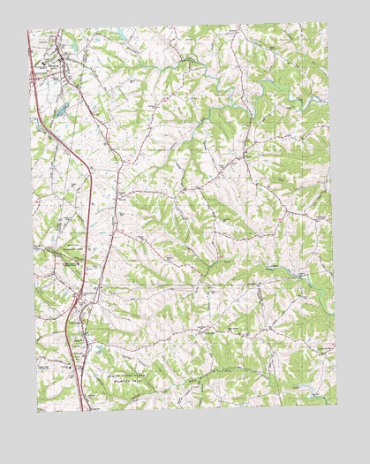
Walton, KY USGS Topographic Map
Click on map above to begin viewing in our Map Viewer.

This topographic map contains these locations and features:
Feature Name Type Latitude Longitude GNIS ID View Map
Allphin CemeteryCemeteryN38.8120°W84.6099°485888View Map
AtwoodPopulated PlaceN38.8723°W84.5383°486128View Map
Atwood Post Office (historical)Post OfficeN38.8728°W84.5376°2557799View Map
Blackwell (historical)Populated PlaceN38.7543°W84.6051°2742185View Map
Boone LakeReservoirN38.8483°W84.6114°487698View Map
BrachtPopulated PlaceN38.8190°W84.5886°507568View Map
Bracht Railroad Station (historical)LocaleN38.8229°W84.5897°2557703View Map
Byland CemeteryCemeteryN38.8578°W84.5824°488556View Map
Carters ChapelChurchN38.7853°W84.5130°489021View Map
City of CrittendenCivilN38.7848°W84.6018°2404156View Map
City of WaltonCivilN38.8645°W84.6122°2405669View Map
Collins CemeteryCemeteryN38.7967°W84.5974°489870View Map
Cook-Smith CemeteryCemeteryN38.7756°W84.5558°490011View Map
CrittendenPopulated PlaceN38.7828°W84.6052°490355View Map
Crittenden Christian CemeteryCemeteryN38.7826°W84.6024°1947726View Map
Crittenden Fire DepartmentBuildingN38.7810°W84.6065°2636496View Map
Crittenden Police DepartmentBuildingN38.7786°W84.6049°2767732View Map
Doud CemeteryCemeteryN38.7878°W84.5510°491054View Map
Fishback CemeteryCemeteryN38.8101°W84.5452°492110View Map
FiskburgPopulated PlaceN38.8106°W84.5069°492144View Map
Fiskburgh Post Office (historical)Post OfficeN38.8105°W84.5055°2557700View Map
FlingsvillePopulated PlaceN38.7734°W84.5544°508012View Map
Gaines Post Office (historical)Post OfficeN38.8622°W84.6098°2569223View Map
Gaines Railroad Station (historical)LocaleN38.8702°W84.6122°2569224View Map
GardnersvillePopulated PlaceN38.7667°W84.5044°508066View Map
Gardnersville Post Office (historical)Post OfficeN38.7675°W84.5047°2564256View Map
Goshen ChurchChurchN38.8292°W84.5402°493046View Map
Goshen School (historical)SchoolN38.8297°W84.5410°2557705View Map
Grayson CemeteryCemeteryN38.8206°W84.5885°493222View Map
Key West Post Office (historical)Post OfficeN38.8183°W84.5886°2557701View Map
Leary LakeReservoirN38.7705°W84.5981°2742190View Map
Mann CemeteryCemeteryN38.7734°W84.5383°497496View Map
Mann-Roshe CemeteryCemeteryN38.7745°W84.5447°497497View Map
Mullins Wildlife AreaParkN38.8038°W84.6081°2557699View Map
Northcutt CemeteryCemeteryN38.8495°W84.5716°499596View Map
Northern Kentucky Treatment CenterBuildingN38.7982°W84.6064°2557698View Map
Pennick-Price CemeteryCemeteryN38.7503°W84.5652°500381View Map
Peoples CemeteryCemeteryN38.8051°W84.5785°500399View Map
PinerPopulated PlaceN38.8315°W84.5358°500724View Map
Piner - Fiskburg Fire Protection DistrictBuildingN38.8307°W84.5396°2636856View Map
Piner Post Office (historical)Post OfficeN38.8318°W84.5358°2557707View Map
Piner-Visalia DivisionCivilN38.8527°W84.5207°1937205View Map
Powers CemeteryCemeteryN38.8234°W84.6083°501259View Map
Rouse CemeteryCemeteryN38.7712°W84.6058°502419View Map
Sawyers ForkStreamN38.8484°W84.5394°503018View Map
Sayers CemeteryCemeteryN38.8134°W84.5885°503021View Map
Sechrest CemeteryCemeteryN38.7548°W84.6038°503142View Map
The Wells (historical)Populated PlaceN38.7616°W84.6055°2742195View Map
Tucker CemeteryCemeteryN38.8287°W84.5433°505537View Map
Walton Fire Protection District Station 1BuildingN38.8681°W84.6139°2636259View Map
Walton Police DepartmentBuildingN38.8665°W84.6112°2767419View Map
Walton Woods ParkParkN38.8695°W84.6059°2569299View Map
Watkins CemeteryCemeteryN38.7981°W84.5688°506275View Map
Wildcat BranchStreamN38.7601°W84.5561°506728View Map
Wilmington Baptist ChurchChurchN38.8105°W84.5047°2725344View Map
Wilmington Baptist Church CemeteryCemeteryN38.8102°W84.5044°2725345View Map
Young CemeteryCemeteryN38.8664°W84.5238°507248View Map

Note: Coordinates in the location and feature list above are referenced to NAD83 datum.


Copyright (C) 2008-2024 Ryan Niemi / Sunset Dynamics ... All Rights Reserved