TopoQuest Logo
Do you find TopoQuest useful?
Help keep TopoQuest running and adding new maps/features by donating!
Bitcoin:  19c7KJd3qBynnjoSw5npx9KScwjBe4ifkT
Litecoin:  LXs6TkuXGGXo1vDsWCkWVdjQX94eUKd6ui
Home View Maps Find Maps Find Places Resources & Links


Williamstown, Kentucky Topographic Map

USGS Map Title: Williamstown, KY
USGS Map MRC: 38084F5
DRG (GeoTIFF) Download: o38084f5.tif


Neighboring USGS Topographic Map Quads:


  Verona, KY  
38084G6
 

  Walton, KY  
38084G5
 

  De Mossville, KY  
38084G4
 

  Elliston, KY  
38084F6
 

  Williamstown, KY  
38084F5
 

  Goforth, KY  
38084F4
 

  Lawrenceville, KY  
38084E6
 

  Mason, KY  
38084E5
 

  Berry, KY  
38084E4


Map MRC Location:

N39°
W85°
N39°
W84°
H8 H7 H6 H5 H4 H3 H2 H1
G8 G7 G6 G5 G4 G3 G2 G1
F8 F7 F6 F5 F4 F3 F2 F1
E8 E7 E6 E5 E4 E3 E2 E1
D8 D7 D6 D5 D4 D3 D2 D1
C8 C7 C6 C5 C4 C3 C2 C1
B8 B7 B6 B5 B4 B3 B2 B1
A8 A7 A6 A5 A4 A3 A2 A1
N38°
W85°
N38°
W84°

Williamstown, KY USGS 1:24K Topographic Map Preview:
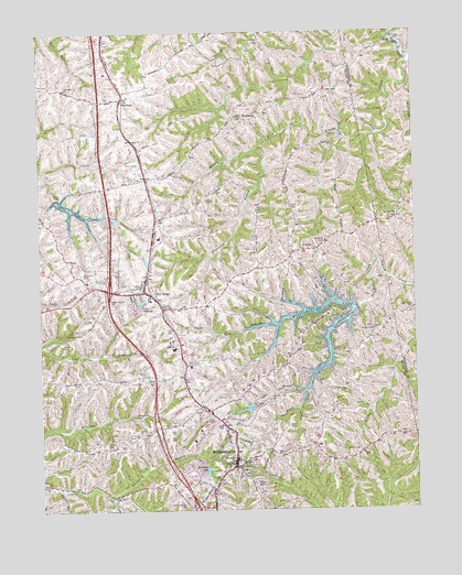
Williamstown, KY USGS Topographic Map
Click on map above to begin viewing in our Map Viewer.

This topographic map contains these locations and features:
Feature Name Type Latitude Longitude GNIS ID View Map
Barnes CemeteryCemeteryN38.6426°W84.6030°486383View Map
Bennette CemeteryCemeteryN38.6773°W84.5002°486864View Map
Boltz LakeReservoirN38.7033°W84.6124°487648View Map
Broad Ridge CemeteryCemeteryN38.6931°W84.5391°487931View Map
Campbells Block House (historical)Populated PlaceN38.6751°W84.5834°2554089View Map
City of Dry RidgeCivilN38.6797°W84.6008°2403510View Map
City of WilliamstownCivilN38.6414°W84.5676°2405749View Map
Clark CemeteryCemeteryN38.7034°W84.5402°489536View Map
Clay CemeteryCemeteryN38.6412°W84.6105°489570View Map
Conrad CemeteryCemeteryN38.6584°W84.5910°489980View Map
Conrads AirportAirportN38.7085°W84.6004°517365View Map
Dey CemeteryCemeteryN38.6634°W84.5763°490854View Map
Dickerson CemeteryCemeteryN38.7473°W84.5513°490877View Map
Dry RidgePopulated PlaceN38.6820°W84.5899°491228View Map
Dry Ridge Fire DepartmentBuildingN38.6813°W84.5933°2636515View Map
Dry Ridge Police DepartmentBuildingN38.6817°W84.5934°2767651View Map
Duncan CemeteryCemeteryN38.6406°W84.5191°491298View Map
Fairview ChurchChurchN38.6717°W84.5141°491926View Map
Fairview RidgeRidgeN38.6628°W84.5188°491931View Map
Goose CreekStreamN38.6765°W84.5205°493004View Map
Grant CountyCivilN38.6488°W84.6246°516887View Map
Grant County Hospital HeliportAirportN38.6359°W84.5683°517506View Map
Grant County Sheriff's OfficeBuildingN38.6493°W84.5752°2767595View Map
Hill Crest CemeteryCemeteryN38.6981°W84.5880°494250View Map
Humes RidgeRidgeN38.6631°W84.5466°494753View Map
Kentucky State Police Post 6BuildingN38.7150°W84.5909°2767758View Map
Knox CemeteryCemeteryN38.7070°W84.5047°495857View Map
KnoxvillePopulated PlaceN38.7012°W84.5058°495863View Map
Knoxville Post Office (historical)Post OfficeN38.7016°W84.5060°2564278View Map
Lake BranchStreamN38.6562°W84.5374°495910View Map
Lake PolliwogReservoirN38.6794°W84.5913°501009View Map
Landrum CemeteryCemeteryN38.6953°W84.5297°495960View Map
Martin CemeteryCemeteryN38.6684°W84.6177°497611View Map
McGuinnis CemeteryCemeteryN38.6709°W84.6110°497875View Map
NorthcuttPopulated PlaceN38.7273°W84.5566°508722View Map
Panther RunStreamN38.6306°W84.6191°500165View Map
Poison Spring (historical)SpringN38.7341°W84.5962°2742193View Map
Railroad LakeReservoirN38.6362°W84.5697°501529View Map
Reid (historical)Populated PlaceN38.7138°W84.5902°2742194View Map
Renneckar CemeteryCemeteryN38.6870°W84.6108°501729View Map
Saint Elizabeth Grant HospitalHospitalN38.6472°W84.5782°2660345View Map
Saint Williams ChurchChurchN38.6481°W84.5591°502761View Map
ShermanPopulated PlaceN38.7326°W84.5966°503357View Map
Sherman ChurchChurchN38.7351°W84.6155°503358View Map
Steammill BranchStreamN38.6287°W84.6013°504297View Map
Tomlin CemeteryCemeteryN38.7492°W84.5069°505340View Map
Townsend BranchStreamN38.7192°W84.5502°505399View Map
Unity CemeteryCemeteryN38.7487°W84.5052°505831View Map
WilliamstownPopulated PlaceN38.6381°W84.5605°506837View Map
Williamstown LakeReservoirN38.6533°W84.5380°506839View Map
Williamstown Volunteer Fire DepartmentBuildingN38.6410°W84.5598°2636847View Map

Note: Coordinates in the location and feature list above are referenced to NAD83 datum.


Copyright (C) 2008-2024 Ryan Niemi / Sunset Dynamics ... All Rights Reserved