TopoQuest Logo
Do you find TopoQuest useful?
Help keep TopoQuest running and adding new maps/features by donating!
Bitcoin:  19c7KJd3qBynnjoSw5npx9KScwjBe4ifkT
Litecoin:  LXs6TkuXGGXo1vDsWCkWVdjQX94eUKd6ui
Home View Maps Find Maps Find Places Resources & Links


Widewater, Virginia Topographic Map

USGS Map Title: Widewater, VA
USGS Map MRC: 38077D3
DRG (GeoTIFF) Download: o38077d3.tif


Neighboring USGS Topographic Map Quads:


  Joplin, VA  
38077E4
 

  Quantico, VA  
38077E3
 

  Indian Head, MD  
38077E2
 

  Stafford, VA  
38077D4
 

  Widewater, VA  
38077D3
 

  Nanjemoy, MD  
38077D2
 

  Fredericksburg, VA  
38077C4
 

  Passapatanzy, VA  
38077C3
 

  King George, VA  
38077C2


Map MRC Location:

N39°
W78°
N39°
W77°
H8 H7 H6 H5 H4 H3 H2 H1
G8 G7 G6 G5 G4 G3 G2 G1
F8 F7 F6 F5 F4 F3 F2 F1
E8 E7 E6 E5 E4 E3 E2 E1
D8 D7 D6 D5 D4 D3 D2 D1
C8 C7 C6 C5 C4 C3 C2 C1
B8 B7 B6 B5 B4 B3 B2 B1
A8 A7 A6 A5 A4 A3 A2 A1
N38°
W78°
N38°
W77°

Widewater, VA USGS 1:24K Topographic Map Preview:
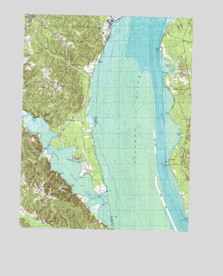
Widewater, VA USGS Topographic Map
Click on map above to begin viewing in our Map Viewer.

This topographic map contains these locations and features:
Feature Name Type Latitude Longitude GNIS ID View Map
Aqua VillaPopulated PlaceN38.4313°W77.3717°2458853View Map
Aquia Bay EstatesPopulated PlaceN38.4181°W77.3716°2458854View Map
Aquia BeachPopulated PlaceN38.4231°W77.3599°2458855View Map
Aquia BendPopulated PlaceN38.4292°W77.3630°2458856View Map
Aquia CreekStreamN38.3923°W77.3155°1462534View Map
Aquia DistrictCivilN38.3965°W77.3683°1927078View Map
Aquia Inlet EstatesPopulated PlaceN38.4234°W77.3635°2458860View Map
Aquia LandingLocaleN38.3878°W77.3174°2458522View Map
Aquia Landing Beach ParkParkN38.3859°W77.3173°2458371View Map
Aquia OverlookPopulated PlaceN38.4429°W77.3656°2458861View Map
Aquia StationLocaleN38.4212°W77.3569°1749075View Map
ArkendalePopulated PlaceN38.4385°W77.3425°1499058View Map
Bayview EstatesPopulated PlaceN38.4204°W77.3673°2458877View Map
Beaverdam CreekStreamN38.4151°W77.2541°583114View Map
Bennetts PointCapeN38.4157°W77.3375°1463074View Map
Blue BanksCliffN38.4507°W77.2619°583298View Map
Blue BayBayN38.4510°W77.2636°1676971View Map
Boars CreekStreamN38.4221°W77.3441°1463616View Map
Brent MarshSwampN38.4401°W77.3250°1463791View Map
Brent PointCapeN38.3976°W77.3108°1463792View Map
Brents Mill Elementary SchoolSchoolN38.4812°W77.3746°2459442View Map
Brooke RidgePopulated PlaceN38.3799°W77.3271°2458908View Map
Brooksmill EstatesPopulated PlaceN38.3862°W77.3638°2458914View Map
Canterbury EstatesPopulated PlaceN38.3794°W77.3145°2458923View Map
Chelsea EstatesPopulated PlaceN38.4861°W77.3432°2458941View Map
Chimney View AirportAirportN38.4039°W77.3157°1498676View Map
Chopawamsic CreekStreamN38.4971°W77.3078°1464872View Map
Clifton BeachBeachN38.4146°W77.2650°583816View Map
Clifton ChapelChurchN38.4743°W77.3411°1464987View Map
Clifton PointCapeN38.4732°W77.3186°1464989View Map
Cole Trip CampLocaleN38.3910°W77.3433°1465079View Map
Colonial PortPopulated PlaceN38.4897°W77.3692°2458955View Map
Cooks Ferry (historical)CrossingN38.4821°W77.2741°1677002View Map
Decatur (historical)Populated PlaceN38.4546°W77.3464°1749093View Map
Decatur StoreLocaleN38.4585°W77.3494°1465688View Map
Douglas PointCapeN38.4446°W77.2650°584140View Map
Estates of Widewater PondPopulated PlaceN38.4108°W77.3251°2458993View Map
Fort McLean (historical)MilitaryN38.3881°W77.3358°1499437View Map
Freds CornerPopulated PlaceN38.4597°W77.3492°2459008View Map
Freedom EstatesPopulated PlaceN38.4560°W77.3525°2459009View Map
Fritters CornerPopulated PlaceN38.3782°W77.3564°1499455View Map
Gourds PointCapeN38.4073°W77.3450°1467299View Map
Green Manor EstatesPopulated PlaceN38.4632°W77.2530°1677033View Map
Griffis-Widewater DistrictCivilN38.4850°W77.3739°1927332View Map
HarrisPopulated PlaceN38.4326°W77.3705°2459034View Map
Holiday Harbor MarinaHarborN38.4281°W77.3594°2520104View Map
Hope Springs MarinaLocaleN38.4227°W77.3580°2458611View Map
Jessica EstatesPopulated PlaceN38.4537°W77.3503°2459072View Map
Landmark Yacht ClubLocaleN38.4004°W77.3379°2458622View Map
Liverpool PointCapeN38.4640°W77.2691°585520View Map
Liverpool WharfPopulated PlaceN38.4576°W77.2647°1677067View Map
Loy LandingPopulated PlaceN38.3937°W77.3303°2459102View Map
Mallows BayBayN38.4726°W77.2686°585669View Map
Mallows CreekStreamN38.4662°W77.2661°1677071View Map
Midway EstatesPopulated PlaceN38.4977°W77.3665°2459126View Map
Midway IslandPopulated PlaceN38.4987°W77.3689°1499742View Map
Mountjoy StoreLocaleN38.4704°W77.3383°1471204View Map
Norman EstatesPopulated PlaceN38.4622°W77.3541°2459142View Map
Northern View EstatesPopulated PlaceN38.4923°W77.3726°2459147View Map
Oak Grove Baptist ChurchChurchN38.4598°W77.3561°1471736View Map
Oak Grove School (historical)SchoolN38.4579°W77.3589°1749133View Map
Patawomack Band Memorial ParkParkN38.3816°W77.3194°2458411View Map
Poplar HillsPopulated PlaceN38.3792°W77.3423°2459174View Map
Purse State ParkParkN38.4304°W77.2528°1677125View Map
Quarry EstatesPopulated PlaceN38.4522°W77.3544°2459183View Map
RaspberryPopulated PlaceN38.4559°W77.3620°2459189View Map
RectoryLocaleN38.4871°W77.3486°1473038View Map
RivendellPopulated PlaceN38.4154°W77.3539°2459196View Map
Salem ChurchChurchN38.4551°W77.3469°1473963View Map
Sams RidgePopulated PlaceN38.4592°W77.3547°2459214View Map
Sandy PointCapeN38.4832°W77.2728°587207View Map
SaratogaPopulated PlaceN38.4621°W77.3652°2459216View Map
Seegars PointCapeN38.4292°W77.3615°1474156View Map
Seventh District Volunteer Rescue Squad Company 59BuildingN38.4428°W77.2844°2086977View Map
Shackley PointCapeN38.4060°W77.3305°1474193View Map
Simms PointCapeN38.3951°W77.3169°1474611View Map
Smith PointCapeN38.4162°W77.2655°587401View Map
Stafford County Fire and Rescue Department Station 3 WidewaterBuildingN38.4711°W77.3378°2331692View Map
Stonebridge at WidewaterPopulated PlaceN38.4916°W77.3673°2459254View Map
Sunshine AcresPopulated PlaceN38.4579°W77.3610°2459268View Map
Sunshine HillsPopulated PlaceN38.4568°W77.3597°2459269View Map
Sunshine ViewPopulated PlaceN38.4789°W77.3430°2459270View Map
Tank CreekStreamN38.4787°W77.3155°1475447View Map
Thorne GutStreamN38.3868°W77.2522°587776View Map
Thorney PointCapeN38.3929°W77.3236°1475665View Map
Thorny Point FarmPopulated PlaceN38.3894°W77.3285°2459286View Map
Uly BrooksPopulated PlaceN38.4221°W77.3240°2459292View Map
Wades BayBayN38.4323°W77.2597°588012View Map
Watsons PointCapeN38.4004°W77.3375°1476392View Map
WidewaterPopulated PlaceN38.4648°W77.3253°1500318View Map
Widewater BeachPopulated PlaceN38.4151°W77.3330°1500319View Map
Widewater Elementary SchoolSchoolN38.4824°W77.3706°1749170View Map
Widewater EstatesPopulated PlaceN38.4854°W77.3485°2459317View Map
Willow LandingLocaleN38.4304°W77.3675°1500326View Map
Willow Landing MarinaHarborN38.4309°W77.3673°2520127View Map
WindermerePopulated PlaceN38.3844°W77.3527°2459326View Map
Youbedamn LandingLocaleN38.3893°W77.3153°1500082View Map

Note: Coordinates in the location and feature list above are referenced to NAD83 datum.


Copyright (C) 2008-2024 Ryan Niemi / Sunset Dynamics ... All Rights Reserved