TopoQuest Logo
Do you find TopoQuest useful?
Help keep TopoQuest running and adding new maps/features by donating!
Bitcoin:  19c7KJd3qBynnjoSw5npx9KScwjBe4ifkT
Litecoin:  LXs6TkuXGGXo1vDsWCkWVdjQX94eUKd6ui
Home View Maps Find Maps Find Places Resources & Links


King George, Virginia Topographic Map

USGS Map Title: King George, VA
USGS Map MRC: 38077C2
DRG (GeoTIFF) Download: o38077c2.tif


Neighboring USGS Topographic Map Quads:


  Widewater, VA  
38077D3
 

  Nanjemoy, MD  
38077D2
 

  Mathias Point, VA  
38077D1
 

  Passapatanzy, VA  
38077C3
 

  King George, VA  
38077C2
 

  Dahlgren, VA  
38077C1
 

  Rappahannock Academy, VA  
38077B3
 

  Port Royal, VA  
38077B2
 

  Rollins Fork, VA  
38077B1


Map MRC Location:

N39°
W78°
N39°
W77°
H8 H7 H6 H5 H4 H3 H2 H1
G8 G7 G6 G5 G4 G3 G2 G1
F8 F7 F6 F5 F4 F3 F2 F1
E8 E7 E6 E5 E4 E3 E2 E1
D8 D7 D6 D5 D4 D3 D2 D1
C8 C7 C6 C5 C4 C3 C2 C1
B8 B7 B6 B5 B4 B3 B2 B1
A8 A7 A6 A5 A4 A3 A2 A1
N38°
W78°
N38°
W77°

King George, VA USGS 1:24K Topographic Map Preview:
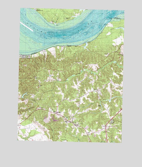
King George, VA USGS Topographic Map
Click on map above to begin viewing in our Map Viewer.

This topographic map contains these locations and features:
Feature Name Type Latitude Longitude GNIS ID View Map
AmbarPopulated PlaceN38.3251°W77.1780°1495193View Map
Antioch Baptist Church CemeteryCemeteryN38.2606°W77.1442°1749173View Map
Antioch ChurchChurchN38.2604°W77.1439°1462516View Map
Arnolds CornerPopulated PlaceN38.2762°W77.2039°1495202View Map
BerthavillePopulated PlaceN38.3335°W77.1258°1495261View Map
Caledon State ParkParkN38.3526°W77.1328°1749175View Map
Cherryfield (historical)Populated PlaceN38.3685°W77.2219°1676996View Map
ComornPopulated PlaceN38.2804°W77.2211°1495418View Map
Company 3BuildingN38.3283°W77.2425°2075321View Map
Dahlgren Rescue SquadBuildingN38.2763°W77.2064°2331652View Map
EdgehillPopulated PlaceN38.2649°W77.1436°1495500View Map
Fairview BeachPopulated PlaceN38.3301°W77.2472°1495523View Map
Fairview Beach Census Designated PlaceCensusN38.3282°W77.2424°2389067View Map
First Baptist ChurchChurchN38.3251°W77.1822°1749179View Map
Halfway CreekStreamN38.3721°W77.1678°1677035View Map
HampsteadPopulated PlaceN38.3335°W77.1416°1495649View Map
Hanover Baptist Church CemeteryCemeteryN38.2679°W77.1389°1749183View Map
Hanover ChurchChurchN38.2682°W77.1391°1467717View Map
Harrison CoveBayN38.3710°W77.2294°1677039View Map
James Monroe DistrictCivilN38.3287°W77.1544°1927356View Map
Jones PondLakeN38.3658°W77.1353°1468856View Map
King GeorgePopulated PlaceN38.2682°W77.1844°1498500View Map
King George Census Designated PlaceCensusN38.2808°W77.1896°2629028View Map
King George CountyCivilN38.2737°W77.1565°1480137View Map
King George County Department of Emergency ServicesBuildingN38.2667°W77.1792°2331770View Map
King George County Sheriff's OfficeBuildingN38.2645°W77.1732°2075324View Map
King George County Sheriff's OfficeBuildingN38.2536°W77.1619°2332054View Map
King George Elementary SchoolSchoolN38.2589°W77.1646°1749187View Map
King George Fire and Rescue Company 1BuildingN38.2764°W77.2070°2075319View Map
King George Fire and Rescue Company 3 Fairview BeachBuildingN38.3283°W77.2425°2331706View Map
King George High SchoolSchoolN38.2765°W77.1980°1469007View Map
King George Lookout Tower (historical)TowerN38.2690°W77.1383°1491179View Map
King George Middle SchoolSchoolN38.2775°W77.2024°1749188View Map
King George Post OfficePost OfficeN38.2782°W77.2101°2767229View Map
Lake MadisonReservoirN38.2723°W77.2166°1490197View Map
Lake Madison DamDamN38.2718°W77.2164°1490196View Map
Lake MonroeReservoirN38.2702°W77.2044°1490199View Map
Lake Monroe DamDamN38.2691°W77.2064°1490198View Map
Lewis Egerton Smoot Memorial LibraryBuildingN38.2660°W77.1780°2519909View Map
Madison Mill DamDamN38.2870°W77.1509°1490200View Map
Maryland PointCapeN38.3601°W77.2069°585723View Map
Mason MillpondReservoirN38.2852°W77.1502°1490201View Map
Merrick Boys CampLocaleN38.3618°W77.2111°585798View Map
Metomkin PointCapeN38.3676°W77.1383°1470384View Map
Mudds MarshSwampN38.3634°W77.2081°586087View Map
OssoPopulated PlaceN38.3098°W77.2305°1496053View Map
Peace ChurchChurchN38.2671°W77.1750°1472144View Map
People Union ChurchChurchN38.3098°W77.2291°1472197View Map
Peoples Union Baptist Church CemeteryCemeteryN38.3093°W77.2291°1749206View Map
Pine Grove ChurchChurchN38.2876°W77.1758°1472349View Map
PopcastleLocaleN38.2643°W77.2497°1472622View Map
Potomac ChurchChurchN38.3023°W77.2239°1472707View Map
Presidential LakeReservoirN38.2941°W77.2420°1490193View Map
Presidential LakesPopulated PlaceN38.2771°W77.2167°2710098View Map
Presidential Lakes DamDamN38.2918°W77.2447°1490192View Map
Purkins CornerPopulated PlaceN38.2574°W77.1653°1496121View Map
Ralph Bunche High School (historical)SchoolN38.2715°W77.1369°1464092View Map
Rescue Squad Station 1BuildingN38.2764°W77.2075°2075322View Map
Saint Anthonys Catholic ChurchChurchN38.2693°W77.1900°1749341View Map
Saint Anthonys CemeteryCemeteryN38.2690°W77.1895°1749209View Map
Saint Stephens Baptist Church CemeteryCemeteryN38.2876°W77.2297°1749212View Map
Saint Stephens ChurchChurchN38.2879°W77.2297°1473916View Map
Somerset BeachPopulated PlaceN38.3412°W77.1830°1496240View Map
Stuart WharfLocaleN38.3612°W77.1453°1475263View Map
WeedonvillePopulated PlaceN38.2985°W77.1586°1496382View Map
Wellington BeachPopulated PlaceN38.3662°W77.1955°591508View Map
Whites CornerPopulated PlaceN38.2518°W77.1905°1496413View Map

Note: Coordinates in the location and feature list above are referenced to NAD83 datum.


Copyright (C) 2008-2024 Ryan Niemi / Sunset Dynamics ... All Rights Reserved