TopoQuest Logo
Do you find TopoQuest useful?
Help keep TopoQuest running and adding new maps/features by donating!
Bitcoin:  19c7KJd3qBynnjoSw5npx9KScwjBe4ifkT
Litecoin:  LXs6TkuXGGXo1vDsWCkWVdjQX94eUKd6ui
Home View Maps Find Maps Find Places Resources & Links


Bucksnort, Tennessee Topographic Map

USGS Map Title: Bucksnort, TN
USGS Map MRC: 35087H6
DRG (GeoTIFF) Download: o35087h6.tif


Neighboring USGS Topographic Map Quads:


  Waverly, TN  
36087A7
 

  McEwen, TN  
36087A6
 

  Tennessee City, TN  
36087A5
 

  Hurricane Mills, TN  
35087H7
 

  Bucksnort, TN  
35087H6
 

  Spot, TN  
35087H5
 

  Lobelville, TN  
35087G7
 

  Coble, TN  
35087G6
 

  Whitfield, TN  
35087G5


Map MRC Location:

N36°
W88°
N36°
W87°
H8 H7 H6 H5 H4 H3 H2 H1
G8 G7 G6 G5 G4 G3 G2 G1
F8 F7 F6 F5 F4 F3 F2 F1
E8 E7 E6 E5 E4 E3 E2 E1
D8 D7 D6 D5 D4 D3 D2 D1
C8 C7 C6 C5 C4 C3 C2 C1
B8 B7 B6 B5 B4 B3 B2 B1
A8 A7 A6 A5 A4 A3 A2 A1
N35°
W88°
N35°
W87°

Bucksnort, TN USGS 1:24K Topographic Map Preview:
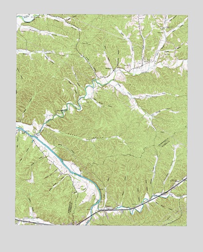
Bucksnort, TN USGS Topographic Map
Click on map above to begin viewing in our Map Viewer.

This topographic map contains these locations and features:
Feature Name Type Latitude Longitude GNIS ID View Map
Baker CemeteryCemeteryN35.9626°W87.6861°1276156View Map
Baptist BranchStreamN35.9695°W87.6500°1276270View Map
Barren Hollow BranchStreamN35.8798°W87.6950°1311336View Map
Barren Hollow BranchStreamN35.8856°W87.6950°1311337View Map
Barren Hollow School (historical)SchoolN35.8792°W87.7403°1316909View Map
Bate HollowValleyN35.8979°W87.6974°1276449View Map
Bell HollowValleyN35.9313°W87.7476°1276941View Map
Bickerstaff EddyRapidsN35.8915°W87.6881°1311339View Map
Bissell HollowValleyN35.9996°W87.7296°1277530View Map
Bold SpringPopulated PlaceN35.9670°W87.6792°1314712View Map
Bold Springs - Poplar Grove Volunteer Fire DepartmentBuildingN35.9732°W87.6275°2653695View Map
Bold Springs Church of ChristChurchN35.9690°W87.6767°1326201View Map
Bold Springs School (historical)SchoolN35.9690°W87.6767°1326202View Map
Bon Spring HollowValleyN35.9509°W87.6961°1277927View Map
Brown HollowValleyN35.9511°W87.7036°1278586View Map
Bryant CemeteryCemeteryN35.9898°W87.7478°1278741View Map
BucksnortPopulated PlaceN35.8856°W87.6845°1314762View Map
Colorado HollowValleyN35.8941°W87.6434°1306050View Map
Duke HollowValleyN35.8856°W87.6855°1283113View Map
Egypt HollowValleyN35.9338°W87.7288°1283576View Map
Epison HollowValleyN35.8869°W87.6726°1283829View Map
Ethridge HollowValleyN35.9400°W87.6511°1283871View Map
Forsee HollowValleyN35.9620°W87.6910°1284655View Map
FurnacePopulated PlaceN35.8934°W87.6406°1306471View Map
Grandfathers BuildingCliffN35.9123°W87.7061°1644752View Map
Haley CemeteryCemeteryN35.9723°W87.6539°1286535View Map
Harden HollowValleyN35.8792°W87.7379°1269623View Map
Harmony Primitive Baptist Church (historical)ChurchN35.9931°W87.6428°1326205View Map
Harmony School (historical)SchoolN35.9923°W87.6431°1316945View Map
Hicks HollowValleyN35.8928°W87.6541°1287666View Map
Interchange 152CrossingN35.8940°W87.6420°1311363View Map
Jones CemeteryCemeteryN35.8795°W87.7397°1289736View Map
Kline HollowValleyN35.9881°W87.6413°1290352View Map
Larkin CemeteryCemeteryN35.9478°W87.6986°1290644View Map
Leathers CemeteryCemeteryN35.9017°W87.6322°1290878View Map
Little HollowValleyN35.9970°W87.6399°1291528View Map
Long ShoalBarN35.8853°W87.6945°1311367View Map
Lowe HollowValleyN35.9256°W87.7370°1292206View Map
Lumber HollowValleyN35.9964°W87.7156°1292269View Map
McClanahan CemeteryCemeteryN35.8753°W87.6845°1293145View Map
McCollum HollowValleyN35.9928°W87.7479°1293045View Map
Mossy Shoals HollowValleyN35.9055°W87.7098°1294521View Map
Old Furnace School (historical)SchoolN35.8920°W87.6395°1319118View Map
Pollock HollowValleyN35.9770°W87.7296°1298074View Map
Potter CemeteryCemeteryN35.8873°W87.6611°1298347View Map
Potter HollowValleyN35.8875°W87.6590°1298355View Map
Pruett CemeteryCemeteryN35.8856°W87.6803°1298618View Map
Pruett CemeteryCemeteryN35.9984°W87.7336°1298619View Map
Pruett HollowValleyN35.9164°W87.7261°1298622View Map
Pullen BranchStreamN35.9862°W87.6409°1313650View Map
Rainey HollowValleyN35.9201°W87.7233°1298841View Map
Reece HollowValleyN35.9358°W87.7461°1299114View Map
Reece SpringSpringN35.9402°W87.7452°1310670View Map
Rice BranchStreamN35.9520°W87.6664°1299294View Map
Rice SpringSpringN35.9517°W87.6511°1299301View Map
Rogers CemeteryCemeteryN35.9712°W87.6611°1316991View Map
Sand Quarry HollowValleyN35.8894°W87.6493°1300675View Map
Sanders CemeteryCemeteryN35.9726°W87.6517°1300692View Map
Schoolhouse HollowValleyN35.9685°W87.6770°1300897View Map
Shop HollowValleyN35.9664°W87.6806°1270167View Map
Silas HollowValleyN35.9560°W87.7000°1270262View Map
Slanting Shoals BranchStreamN35.9103°W87.7150°1270466View Map
Snake CreekStreamN35.9351°W87.7286°1310673View Map
South Fork Sugar CreekStreamN35.8931°W87.6378°1270887View Map
Sparks CemeteryCemeteryN35.9762°W87.6375°1270960View Map
Spence HollowValleyN35.8931°W87.6496°1270982View Map
Spot HollowValleyN35.8938°W87.6377°1271023View Map
Standing RockPillarN35.9306°W87.7367°1271221View Map
Stringer HollowValleyN35.9784°W87.6453°1271597View Map
Sugar CreekStreamN35.8890°W87.6889°1271674View Map
Tanyard BranchStreamN35.9612°W87.6806°1272101View Map
Tatem HollowValleyN35.9875°W87.6411°1272159View Map
Taylor CemeteryCemeteryN35.9401°W87.7270°1272206View Map
TaylortownPopulated PlaceN35.9326°W87.7295°1314384View Map
Tumbling CreekStreamN35.9278°W87.7370°1272971View Map
Vineyard CemeteryCemeteryN35.9895°W87.6431°1273471View Map
Wallace BranchStreamN35.9640°W87.6656°1273663View Map
Water ValleyPopulated PlaceN35.9928°W87.6425°1313651View Map
Water Valley ChurchChurchN35.9928°W87.6411°1304405View Map
Weatherspoon HollowValleyN35.8762°W87.7459°1273980View Map
Well HollowValleyN35.8767°W87.7474°1274093View Map
Wheeler BranchStreamN35.9648°W87.6647°1274282View Map
Wheeler CemeteryCemeteryN35.9976°W87.6614°1274285View Map
Wills ChapelChurchN35.9428°W87.7156°1274776View Map
Wills ChapelPopulated PlaceN35.9426°W87.7161°1313652View Map
Wills Chapel School (historical)SchoolN35.9426°W87.7159°1317017View Map
Woodward BranchStreamN35.9981°W87.7459°1275103View Map
Young BranchStreamN35.9398°W87.6506°1310680View Map
Young CemeteryCemeteryN35.9701°W87.6678°1275323View Map

Note: Coordinates in the location and feature list above are referenced to NAD83 datum.


Copyright (C) 2008-2024 Ryan Niemi / Sunset Dynamics ... All Rights Reserved