TopoQuest Logo
Do you find TopoQuest useful?
Help keep TopoQuest running and adding new maps/features by donating!
Bitcoin:  19c7KJd3qBynnjoSw5npx9KScwjBe4ifkT
Litecoin:  LXs6TkuXGGXo1vDsWCkWVdjQX94eUKd6ui
Home View Maps Find Maps Find Places Resources & Links


Deep Run, North Carolina Topographic Map

USGS Map Title: Deep Run, NC
USGS Map MRC: 35077B6
DRG (GeoTIFF) Download: o35077b6.tif


Neighboring USGS Topographic Map Quads:


  La Grange, NC  
35077C7
 

  Falling Creek, NC  
35077C6
 

  Kinston, NC  
35077C5
 

  Seven Springs, NC  
35077B7
 

  Deep Run, NC  
35077B6
 

  Rivermont, NC  
35077B5
 

  Albertson, NC  
35077A7
 

  Pink Hill, NC  
35077A6
 

  Comfort, NC  
35077A5


Map MRC Location:

N36°
W78°
N36°
W77°
H8 H7 H6 H5 H4 H3 H2 H1
G8 G7 G6 G5 G4 G3 G2 G1
F8 F7 F6 F5 F4 F3 F2 F1
E8 E7 E6 E5 E4 E3 E2 E1
D8 D7 D6 D5 D4 D3 D2 D1
C8 C7 C6 C5 C4 C3 C2 C1
B8 B7 B6 B5 B4 B3 B2 B1
A8 A7 A6 A5 A4 A3 A2 A1
N35°
W78°
N35°
W77°

Deep Run, NC USGS 1:24K Topographic Map Preview:
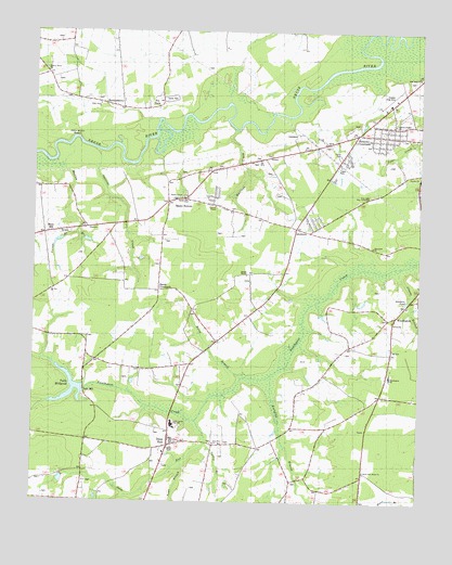
Deep Run, NC USGS Topographic Map
Click on map above to begin viewing in our Map Viewer.

This topographic map contains these locations and features:
Feature Name Type Latitude Longitude GNIS ID View Map
AlbrittonsPopulated PlaceN35.1979°W77.6650°980080View Map
Blands CrossroadsPopulated PlaceN35.1813°W77.7091°1006133View Map
BucklesberryPopulated PlaceN35.2302°W77.7205°1006145View Map
Clarks BranchStreamN35.1796°W77.6277°983229View Map
Deep RunStreamN35.1479°W77.6950°1019939View Map
Deep RunPopulated PlaceN35.1454°W77.7039°984093View Map
Deep Run ChurchChurchN35.1407°W77.6908°1004215View Map
Deep Run Church of GodChurchN35.1392°W77.7174°2505869View Map
Deep Run Fire DistrictCivilN35.1402°W77.7041°1002649View Map
Deep Run Post OfficePost OfficeN35.1426°W77.7056°2505355View Map
Deep Run SchoolSchoolN35.1460°W77.7041°984098View Map
Deep Run Volunteer Fire DepartmentBuildingN35.1399°W77.7052°1002651View Map
Falling CreekStreamN35.2485°W77.6433°984984View Map
Gospel ChurchChurchN35.2213°W77.6564°1004209View Map
Gray BranchStreamN35.1260°W77.7175°1023999View Map
Hickory Grove ChurchChurchN35.2399°W77.7466°1004206View Map
Holly Grove ChurchChurchN35.2302°W77.7286°986949View Map
Hornpipe BranchStreamN35.1496°W77.6705°987073View Map
Horse BranchStreamN35.1577°W77.6811°987079View Map
Howard Place Mobile Home ParkPopulated PlaceN35.1902°W77.6691°2505611View Map
Jackson Heights Census Designated PlaceCensusN35.2236°W77.6332°2628639View Map
Jackson Heights ChurchChurchN35.2257°W77.6330°1004208View Map
Jackson Heights Mobile Home ParkPopulated PlaceN35.2168°W77.6356°2505474View Map
Jackson HightsPopulated PlaceN35.2224°W77.6355°1002646View Map
Jacksons CrossroadsPopulated PlaceN35.2235°W77.6458°987501View Map
Ketchum PondLakeN35.1785°W77.6290°987944View Map
Kinston Drag StripLocaleN35.2329°W77.6339°1002668View Map
Lawson ChapelChurchN35.2041°W77.6914°988227View Map
Lenoir CountyCivilN35.2388°W77.6412°1008568View Map
Macedonia ChurchChurchN35.1932°W77.6400°1004213View Map
Manley BranchStreamN35.2127°W77.7394°989275View Map
Moss HillPopulated PlaceN35.1963°W77.7464°990291View Map
Mount Zion ChurchChurchN35.1810°W77.7439°990638View Map
New Hope ChurchChurchN35.2382°W77.6255°991005View Map
North Lenoir Fire and Rescue Station 3BuildingN35.2354°W77.7086°2639366View Map
Peoples ChurchChurchN35.2113°W77.6252°1004210View Map
Pine Bush BeachBeachN35.2210°W77.7380°992232View Map
Pot NeckPopulated PlaceN35.2302°W77.7100°1004207View Map
Sandy BottomPopulated PlaceN35.2060°W77.7008°994252View Map
Sandy Bottom Fire DistrictCivilN35.2052°W77.7003°1001113View Map
Sandy Bottom Volunteer Fire and RescueBuildingN35.2052°W77.7005°1001114View Map
Smith New Home ChurchChurchN35.1332°W77.6422°1024307View Map
South Lenoir High SchoolSchoolN35.1458°W77.7029°1004214View Map
Squirrel CreekStreamN35.2179°W77.7297°995385View Map
Stanley MissionChurchN35.1857°W77.6805°995414View Map
Toms BranchStreamN35.1343°W77.7008°996143View Map
Township of NeuseCivilN35.2128°W77.6489°1026879View Map
Township of TrentCivilN35.1671°W77.7490°1026883View Map
True Light Holy TabernacleChurchN35.2066°W77.6408°1004212View Map
Tull MillpondReservoirN35.1525°W77.7391°998451View Map
Tull Millpond DamDamN35.1552°W77.7364°998450View Map
Tulls MillPopulated PlaceN35.1532°W77.7325°1022997View Map
Turkey BranchStreamN35.1410°W77.6933°996314View Map
Vernon BranchStreamN35.1966°W77.7350°996608View Map
Webbs ChapelChurchN35.2054°W77.7039°1004211View Map
Whitelace CreekStreamN35.2313°W77.6869°1023490View Map
Whitleys CreekStreamN35.2238°W77.6847°997270View Map
WoodingtonPopulated PlaceN35.1741°W77.6355°997583View Map
Woodington SchoolSchoolN35.1588°W77.6339°1004216View Map

Note: Coordinates in the location and feature list above are referenced to NAD83 datum.


Copyright (C) 2008-2024 Ryan Niemi / Sunset Dynamics ... All Rights Reserved