TopoQuest Logo
Do you find TopoQuest useful?
Help keep TopoQuest running and adding new maps/features by donating!
Bitcoin:  19c7KJd3qBynnjoSw5npx9KScwjBe4ifkT
Litecoin:  LXs6TkuXGGXo1vDsWCkWVdjQX94eUKd6ui
Home View Maps Find Maps Find Places Resources & Links


Falling Creek, North Carolina Topographic Map

USGS Map Title: Falling Creek, NC
USGS Map MRC: 35077C6
DRG (GeoTIFF) Download: o35077c6.tif


Neighboring USGS Topographic Map Quads:


  Jason, NC  
35077D7
 

  Snow Hill, NC  
35077D6
 

  Hookerton, NC  
35077D5
 

  La Grange, NC  
35077C7
 

  Falling Creek, NC  
35077C6
 

  Kinston, NC  
35077C5
 

  Seven Springs, NC  
35077B7
 

  Deep Run, NC  
35077B6
 

  Rivermont, NC  
35077B5


Map MRC Location:

N36°
W78°
N36°
W77°
H8 H7 H6 H5 H4 H3 H2 H1
G8 G7 G6 G5 G4 G3 G2 G1
F8 F7 F6 F5 F4 F3 F2 F1
E8 E7 E6 E5 E4 E3 E2 E1
D8 D7 D6 D5 D4 D3 D2 D1
C8 C7 C6 C5 C4 C3 C2 C1
B8 B7 B6 B5 B4 B3 B2 B1
A8 A7 A6 A5 A4 A3 A2 A1
N35°
W78°
N35°
W77°

Falling Creek, NC USGS 1:24K Topographic Map Preview:
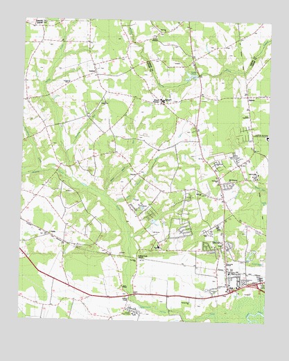
Falling Creek, NC USGS Topographic Map
Click on map above to begin viewing in our Map Viewer.

This topographic map contains these locations and features:
Feature Name Type Latitude Longitude GNIS ID View Map
Banks ChapelChurchN35.2641°W77.6969°1024494View Map
Banks Elementary SchoolSchoolN35.2808°W77.6811°1024867View Map
Bethel ChurchChurchN35.2827°W77.6469°1004073View Map
Beulah ChurchChurchN35.2952°W77.6422°981265View Map
Bible Missionary ChurchChurchN35.3091°W77.6444°1004068View Map
BranchwoodPopulated PlaceN35.3021°W77.6661°1024926View Map
Briarwood TerracePopulated PlaceN35.2785°W77.6497°1024923View Map
Bryant TabernacleChurchN35.3679°W77.6836°1004062View Map
Castle OaksPopulated PlaceN35.2885°W77.6664°1024924View Map
Church of the NazareneChurchN35.2746°W77.6455°1004074View Map
County AcresPopulated PlaceN35.2663°W77.6408°1024919View Map
County Square EstatesPopulated PlaceN35.3163°W77.6505°1002602View Map
Dailey SchoolSchoolN35.2932°W77.6630°983911View Map
DawsonPopulated PlaceN35.3452°W77.6364°1006172View Map
Dobbs SchoolSchoolN35.3124°W77.6314°1004067View Map
Falling CreekPopulated PlaceN35.2621°W77.6905°984981View Map
Falling Creek StationLocaleN35.2766°W77.6905°984988View Map
FieldsPopulated PlaceN35.2838°W77.7308°1006201View Map
Foxtail Mobile Home ParkPopulated PlaceN35.3198°W77.6537°2505586View Map
Grays Millpond DamDamN35.3518°W77.6630°998859View Map
Groundnut CreekStreamN35.3124°W77.7400°986173View Map
Gum Swamp CreekStreamN35.2982°W77.7019°986246View Map
Hardison CrossroadsLocaleN35.3179°W77.7133°1023493View Map
Herring Grove ChurchChurchN35.2585°W77.6633°1004078View Map
Hickory HillsPopulated PlaceN35.2877°W77.6541°1024925View Map
Hillcrest FarmsPopulated PlaceN35.2799°W77.6302°1024921View Map
Holly Hill ChurchChurchN35.3035°W77.6580°1004070View Map
Hull Road ChurchChurchN35.3088°W77.6500°1004069View Map
HullwoodPopulated PlaceN35.3068°W77.6458°1024927View Map
InstitutePopulated PlaceN35.3577°W77.7139°987387View Map
Jones TabernacleChurchN35.3357°W77.6352°1004509View Map
Jumping RunStreamN35.3216°W77.7283°987817View Map
Jumping Run ChurchChurchN35.3407°W77.7083°1004059View Map
Kennedy Memorial HomeBuildingN35.2529°W77.6916°1024495View Map
Kinstonian HightsPopulated PlaceN35.2677°W77.6444°1002601View Map
Moseley CreekStreamN35.3099°W77.7247°1027431View Map
Mount Vernon ParkPopulated PlaceN35.2682°W77.6377°1024918View Map
New Birth ChurchChurchN35.2752°W77.6905°1004071View Map
North Lenoir Fire and Rescue Station 1BuildingN35.3025°W77.6468°1001115View Map
North Lenoir Fire and Rescue Station 2BuildingN35.3249°W77.6621°2638742View Map
North Lenoir Fire DistrictCivilN35.3013°W77.6464°1002652View Map
North Lenoir High SchoolSchoolN35.3420°W77.6759°1004063View Map
Oak Grove ChurchChurchN35.3707°W77.6786°1004061View Map
Oakview SchoolSchoolN35.3329°W77.7036°991487View Map
Orridge SchoolSchoolN35.3343°W77.7414°991694View Map
ParrotsPopulated PlaceN35.3113°W77.6908°1004066View Map
Pecan Grove Mobile Home ParkPopulated PlaceN35.3178°W77.7213°2505543View Map
Pinelawn CemeteryCemeteryN35.2635°W77.6527°1004077View Map
Pulley PondReservoirN35.3521°W77.6651°1004064View Map
Random WoodsPopulated PlaceN35.2827°W77.6441°1024922View Map
Rochelle CornersPopulated PlaceN35.2688°W77.6272°1024920View Map
Saint Marks ChurchChurchN35.3491°W77.7500°1024662View Map
Temple Israel CemeteryCemeteryN35.2650°W77.6491°1004076View Map
Township of Falling CreekCivilN35.2678°W77.6807°1026875View Map
Township of InstituteCivilN35.3340°W77.7148°1026876View Map
Trinity ChurchChurchN35.2618°W77.6914°1004072View Map
Trinity WoodsPopulated PlaceN35.3113°W77.6436°1024928View Map
Tyndall SchoolSchoolN35.3546°W77.6341°996399View Map
WELS-AM (Kinston)TowerN35.2627°W77.6261°1018421View Map
Westview CemeteryCemeteryN35.2668°W77.6358°1004075View Map
WFTC-AM (Kinston)TowerN35.2832°W77.6500°1018425View Map
Wheat SwampPopulated PlaceN35.3407°W77.6789°1004060View Map
Wheat Swamp ChurchChurchN35.3421°W77.6805°997103View Map
Wheat Swamp SchoolSchoolN35.3443°W77.6578°997104View Map
White Marsh RunStreamN35.3021°W77.7080°1004065View Map
WRNS-FM (Kinston)TowerN35.2832°W77.6500°1018256View Map

Note: Coordinates in the location and feature list above are referenced to NAD83 datum.


Copyright (C) 2008-2024 Ryan Niemi / Sunset Dynamics ... All Rights Reserved