TopoQuest Logo
Do you find TopoQuest useful?
Help keep TopoQuest running and adding new maps/features by donating!
Bitcoin:  19c7KJd3qBynnjoSw5npx9KScwjBe4ifkT
Litecoin:  LXs6TkuXGGXo1vDsWCkWVdjQX94eUKd6ui
Home View Maps Find Maps Find Places Resources & Links


Neck City, Missouri Topographic Map

USGS Map Title: Neck City, MO
USGS Map MRC: 37094C4
DRG (GeoTIFF) Download: o37094c4.tif


Neighboring USGS Topographic Map Quads:


  Mindenmines, MO  
37094D5
 

  Nashville, MO  
37094D4
 

  Lamar South, MO  
37094D3
 

  Asbury, MO  
37094C5
 

  Neck City, MO  
37094C4
 

  Jasper, MO  
37094C3
 

  Carl Junction, MO  
37094B5
 

  Webb City, MO  
37094B4
 

  Carthage, MO  
37094B3


Map MRC Location:

N38°
W95°
N38°
W94°
H8 H7 H6 H5 H4 H3 H2 H1
G8 G7 G6 G5 G4 G3 G2 G1
F8 F7 F6 F5 F4 F3 F2 F1
E8 E7 E6 E5 E4 E3 E2 E1
D8 D7 D6 D5 D4 D3 D2 D1
C8 C7 C6 C5 C4 C3 C2 C1
B8 B7 B6 B5 B4 B3 B2 B1
A8 A7 A6 A5 A4 A3 A2 A1
N37°
W95°
N37°
W94°

Neck City, MO USGS 1:24K Topographic Map Preview:
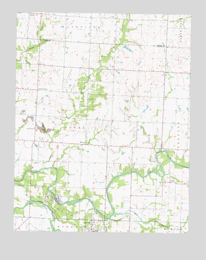
Neck City, MO USGS Topographic Map
Click on map above to begin viewing in our Map Viewer.

This topographic map contains these locations and features:
Feature Name Type Latitude Longitude GNIS ID View Map
Barker LakeReservoirN37.3084°W94.4369°763337View Map
Barker Lake DamDamN37.3084°W94.4369°763336View Map
Bradford CemeteryCemeteryN37.3162°W94.4197°714612View Map
Breeze (historical)LocaleN37.2906°W94.4563°740490View Map
Buck BranchStreamN37.2606°W94.4288°714949View Map
Cedar Bluff CemeteryCemeteryN37.2920°W94.3994°715567View Map
Cedar Bluff School (historical)SchoolN37.2992°W94.4141°746061View Map
City of Neck CityCivilN37.2549°W94.4449°2395163View Map
Cliffwood (historical)LocaleN37.2692°W94.4816°740489View Map
Coon Foot School (historical)SchoolN37.2708°W94.4164°746062View Map
CossvillePopulated PlaceN37.3259°W94.4483°716336View Map
Diamond School (historical)SchoolN37.3723°W94.3924°746205View Map
Duval CreekStreamN37.2859°W94.4802°717221View Map
Gresham CemeteryCemeteryN37.2892°W94.4855°718865View Map
Lynnland School (historical)SchoolN37.3276°W94.3763°746059View Map
NashvillePopulated PlaceN37.3745°W94.4908°723124View Map
Nashville CemeteryCemeteryN37.3749°W94.4834°2681298View Map
Neck CityPopulated PlaceN37.2570°W94.4444°729933View Map
Neck City Post OfficePost OfficeN37.2555°W94.4444°2782562View Map
Neck City SchoolSchoolN37.2552°W94.4453°745704View Map
New Providence ChurchChurchN37.3087°W94.4855°723293View Map
Pine CemeteryCemeteryN37.2895°W94.4622°724368View Map
Pine School (historical)SchoolN37.2870°W94.4516°746058View Map
Prairie Star School (historical)SchoolN37.3453°W94.4791°746055View Map
PrestonPopulated PlaceN37.2792°W94.3891°724915View Map
Preston School (historical)SchoolN37.2795°W94.3852°746063View Map
Rosebank School (historical)SchoolN37.3303°W94.4302°746060View Map
Shapley CemeteryCemeteryN37.3728°W94.4288°726272View Map
Shapley School (historical)SchoolN37.3645°W94.4297°746206View Map
Shelton LakeReservoirN37.3558°W94.4216°762844View Map
Shelton Lake DamDamN37.3567°W94.4236°762843View Map
Slater BranchStreamN37.2867°W94.4727°726531View Map
Township of DuvalCivilN37.3078°W94.4502°766807View Map
Tri - Cities Fire Protection District Station 3BuildingN37.3012°W94.4835°2620498View Map
Tuckers CornerPopulated PlaceN37.3306°W94.4847°727828View Map
Valley Dell School (historical)SchoolN37.3173°W94.4861°746056View Map
View Bank School (historical)SchoolN37.2876°W94.4883°746057View Map

Note: Coordinates in the location and feature list above are referenced to NAD83 datum.


Copyright (C) 2008-2024 Ryan Niemi / Sunset Dynamics ... All Rights Reserved