TopoQuest Logo
Do you find TopoQuest useful?
Help keep TopoQuest running and adding new maps/features by donating!
Bitcoin:  19c7KJd3qBynnjoSw5npx9KScwjBe4ifkT
Litecoin:  LXs6TkuXGGXo1vDsWCkWVdjQX94eUKd6ui
Home View Maps Find Maps Find Places Resources & Links


Coronado Mountain, Arizona Topographic Map

USGS Map Title: Coronado Mountain, AZ
USGS Map MRC: 33109B4
DRG (GeoTIFF) Download: o33109b4.tif


Neighboring USGS Topographic Map Quads:


  Willow Mountain SE, AZ  
33109C5
 

  Bee Canyon, AZ  
33109C4
 

  Pipestem Mountain, AZ  
33109C3
 

  Elevator Mountain, AZ  
33109B5
 

  Coronado Mountain, AZ  
33109B4
 

  Mitchell Peak, AZ  
33109B3
 

  Bonita Spring, AZ  
33109A5
 

  Copperplate Gulch, AZ  
33109A4
 

  Clifton, AZ  
33109A3


Map MRC Location:

N34°
W110°
N34°
W109°
H8 H7 H6 H5 H4 H3 H2 H1
G8 G7 G6 G5 G4 G3 G2 G1
F8 F7 F6 F5 F4 F3 F2 F1
E8 E7 E6 E5 E4 E3 E2 E1
D8 D7 D6 D5 D4 D3 D2 D1
C8 C7 C6 C5 C4 C3 C2 C1
B8 B7 B6 B5 B4 B3 B2 B1
A8 A7 A6 A5 A4 A3 A2 A1
N33°
W110°
N33°
W109°

Coronado Mountain, AZ USGS 1:24K Topographic Map Preview:
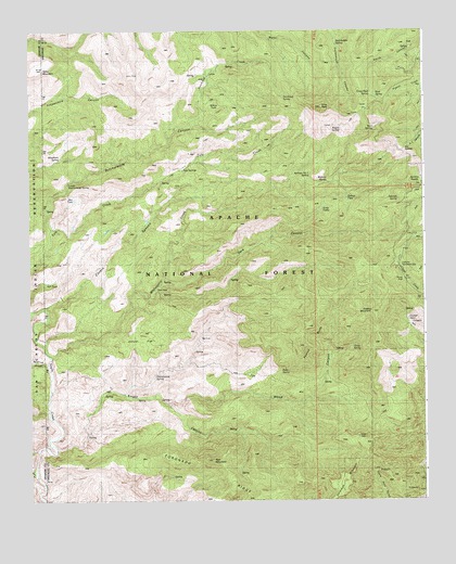
Coronado Mountain, AZ USGS Topographic Map
Click on map above to begin viewing in our Map Viewer.

This topographic map contains these locations and features:
Feature Name Type Latitude Longitude GNIS ID View Map
Ben TankReservoirN33.2053°W109.4860°39912View Map
Benchmark Tank Number 1ReservoirN33.2367°W109.4623°42677View Map
Benchmark Tank Number 2ReservoirN33.2441°W109.4615°42489View Map
Big Bend SpringSpringN33.1953°W109.4192°42482View Map
Birkner TankReservoirN33.2042°W109.3995°39917View Map
Blue TankReservoirN33.1918°W109.4916°42498View Map
Box SpringSpringN33.2023°W109.4946°42496View Map
Buck SpringSpringN33.1298°W109.4940°1853514View Map
Butcher Knife CorralLocaleN33.2209°W109.4742°42491View Map
Butcher Knife SpringSpringN33.2142°W109.4757°42495View Map
Butcher TankReservoirN33.1981°W109.4926°42497View Map
Butcherknife CanyonValleyN33.1981°W109.4937°27076View Map
Cement TankReservoirN33.1984°W109.4923°27456View Map
Cherry Lodge Picnic AreaLocaleN33.1840°W109.3823°40543View Map
Cistern CanyonValleyN33.1781°W109.4901°27671View Map
Cistern Canyon TankReservoirN33.2112°W109.4456°1853507View Map
Cistern TankReservoirN33.1997°W109.4630°42486View Map
Coronado MountainSummitN33.1298°W109.4023°27968View Map
Coronado RidgeRidgeN33.1312°W109.4420°27970View Map
Cotton TankReservoirN33.1612°W109.3867°1853515View Map
Cottonwood CorralLocaleN33.1551°W109.4770°42467View Map
Cottonwood SpringSpringN33.1539°W109.4762°42468View Map
Cottonwood Spring Trough TankReservoirN33.2337°W109.4726°42515View Map
Couple SpringSpringN33.2245°W109.4037°42513View Map
Crystal SpringSpringN33.1755°W109.3814°42502View Map
Curve SpringSpringN33.1567°W109.4076°42500View Map
Dark CanyonValleyN33.1828°W109.4562°28278View Map
Dark SpringSpringN33.1943°W109.4319°42488View Map
Deerhead CorralLocaleN33.2384°W109.4240°42492View Map
Deerhead CreekStreamN33.2265°W109.4479°28403View Map
Deerhead RanchLocaleN33.2406°W109.4401°1853513View Map
Deerhead Ranch TanksReservoirN33.2405°W109.4404°1853511View Map
Deerhead SpringSpringN33.2322°W109.4194°28404View Map
Deerhead Tank Number 2ReservoirN33.2365°W109.4370°1853516View Map
Enebro MountainSummitN33.1751°W109.3923°28908View Map
Fence TankReservoirN33.1845°W109.4965°40539View Map
GranvillePopulated PlaceN33.1890°W109.3826°39987View Map
Granville CampgroundLocaleN33.1876°W109.3831°39988View Map
Granville Recreation AreaParkN33.1890°W109.3834°29503View Map
Granville SpringSpringN33.1920°W109.3804°42503View Map
Grey PeakSummitN33.2295°W109.4087°29598View Map
Grey Peak SpringSpringN33.2331°W109.3918°39991View Map
H L SaddleGapN33.2165°W109.3817°29645View Map
H L Saddle Picnic AreaParkN33.2167°W109.3829°1853509View Map
H L Saddle TankReservoirN33.2234°W109.3831°40542View Map
Halfmile TankReservoirN33.2401°W109.4406°42493View Map
Halfmile TankReservoirN33.2331°W109.4412°42512View Map
Highway Camp SpringSpringN33.2452°W109.3794°42505View Map
Horse Pasture TankReservoirN33.1832°W109.4948°40538View Map
Hughes SpringSpringN33.1657°W109.3984°39986View Map
Javaline TankReservoirN33.1940°W109.4006°42689View Map
Juniper FlatFlatN33.1673°W109.4634°30655View Map
Juniper TankReservoirN33.2022°W109.4616°42487View Map
Knight CanyonValleyN33.1390°W109.4923°30800View Map
Knight CreekStreamN33.1387°W109.4906°40013View Map
Knight SpringSpringN33.1437°W109.4373°42465View Map
Lower Butcherknife SpringSpringN33.2098°W109.4878°31339View Map
Lower Cottonwood SpringSpringN33.1424°W109.4824°42469View Map
Lower Hughes SpringSpringN33.1650°W109.4009°42501View Map
Lower Sanburn TanksReservoirN33.2060°W109.4475°42483View Map
Main SpringSpringN33.2234°W109.3917°31459View Map
Maple SpringSpringN33.2116°W109.3785°40028View Map
Milkshake SpringSpringN33.1258°W109.4932°1853517View Map
Mud SpringSpringN33.2236°W109.3909°32099View Map
Mule Canyon TankReservoirN33.2256°W109.4398°42479View Map
Painted BluffsSummitN33.1715°W109.4117°40050View Map
Pinto SpringSpringN33.1595°W109.4208°33015View Map
Pistol CreekStreamN33.1320°W109.4979°33036View Map
Pot TankReservoirN33.2221°W109.4361°42477View Map
Rattlesnake TankReservoirN33.2005°W109.4643°42476View Map
Red MountainSummitN33.1356°W109.4426°33479View Map
Red Saddle SpringSpringN33.2469°W109.4027°28034View Map
Red SpringSpringN33.1966°W109.3810°1853506View Map
Ridge SpringSpringN33.1324°W109.4341°42464View Map
Rock TankReservoirN33.2409°W109.4592°42494View Map
Saltground TankReservoirN33.2383°W109.4428°1853512View Map
Santa Rosa MineLocaleN33.1348°W109.3934°40483View Map
Santa Rosa MountainSummitN33.1390°W109.3923°40484View Map
Sardine SaddleGapN33.2103°W109.3776°34088View Map
Sawmill CorralLocaleN33.2037°W109.3829°42504View Map
Sawmill SpringSpringN33.2049°W109.3832°34111View Map
Slide-in TankReservoirN33.1984°W109.4862°42474View Map
Small TankReservoirN33.2490°W109.4720°40084View Map
Spur CrossPopulated PlaceN33.1834°W109.4579°34758View Map
Spur Cross CorralLocaleN33.1895°W109.4754°42471View Map
Stove TankReservoirN33.2028°W109.4070°40102View Map
Stove TanksReservoirN33.2031°W109.4067°40541View Map
Sycamore CanyonValleyN33.1617°W109.4959°35022View Map
Table MountainSummitN33.2401°W109.4956°35090View Map
Table Top Number Two TankReservoirN33.2431°W109.4812°40108View Map
Table Top TankReservoirN33.2415°W109.4785°42490View Map
Tule SpringsSpringN33.2131°W109.4520°35510View Map
Tule Springs RanchLocaleN33.2128°W109.4517°40114View Map
Tule TankReservoirN33.2123°W109.4464°1853510View Map
Tule Tank Number TwoReservoirN33.2122°W109.4367°42484View Map
Tule Tule Number 1ReservoirN33.2125°W109.4445°1853552View Map
Upper Cottonwood SpringSpringN33.1584°W109.4603°39955View Map
Upper Distill SpringSpringN33.2242°W109.4498°42514View Map
Upper Eagle Creek CorralLocaleN33.1634°W109.4929°42499View Map
Upper Open Drawer TankReservoirN33.1973°W109.4762°42473View Map
Upper Sanburn TanksReservoirN33.2059°W109.4451°42485View Map
Wagon CorralLocaleN33.2212°W109.4051°42478View Map
Wagon SpringSpringN33.2245°W109.4037°40124View Map
Webster CorralLocaleN33.2084°W109.4248°42481View Map
Webster SpringSpringN33.2076°W109.4259°42480View Map
Webster SpringSpringN33.2096°W109.4061°35939View Map
White TankReservoirN33.2058°W109.4610°42475View Map
Whitethorn SpringSpringN33.2162°W109.4904°36122View Map
Whitewater CreekStreamN33.1634°W109.4940°36127View Map
Willow TankReservoirN33.2308°W109.4417°40536View Map
Wood CanyonValleyN33.1503°W109.4556°36362View Map
Wood SpringSpringN33.1524°W109.4661°42466View Map
Wright SpringSpringN33.1840°W109.4367°42470View Map

Note: Coordinates in the location and feature list above are referenced to NAD83 datum.


Copyright (C) 2008-2024 Ryan Niemi / Sunset Dynamics ... All Rights Reserved