TopoQuest Logo
Do you find TopoQuest useful?
Help keep TopoQuest running and adding new maps/features by donating!
Bitcoin:  19c7KJd3qBynnjoSw5npx9KScwjBe4ifkT
Litecoin:  LXs6TkuXGGXo1vDsWCkWVdjQX94eUKd6ui
Home View Maps Find Maps Find Places Resources & Links


Crab Lake, Minnesota Topographic Map

USGS Map Title: Crab Lake, MN
USGS Map MRC: 47092H1
DRG (GeoTIFF) Download: o47092h1.tif


Neighboring USGS Topographic Map Quads:


  Bootleg Lake, MN  
48092A2
 

  Lapond Lake, MN  
48092A1
 

  Angleworm Lake, MN  
48091A8
 

  Chad Lake, MN  
47092H2
 

  Crab Lake, MN  
47092H1
 

  Shagawa Lake, MN  
47091H8
 

  Soudan, MN  
47092G2
 

  Eagles Nest, MN  
47092G1
 

  Bear Island, MN  
47091G8


Map MRC Location:

N48°
W93°
N48°
W92°
H8 H7 H6 H5 H4 H3 H2 H1
G8 G7 G6 G5 G4 G3 G2 G1
F8 F7 F6 F5 F4 F3 F2 F1
E8 E7 E6 E5 E4 E3 E2 E1
D8 D7 D6 D5 D4 D3 D2 D1
C8 C7 C6 C5 C4 C3 C2 C1
B8 B7 B6 B5 B4 B3 B2 B1
A8 A7 A6 A5 A4 A3 A2 A1
N47°
W93°
N47°
W92°

Crab Lake, MN USGS 1:24K Topographic Map Preview:
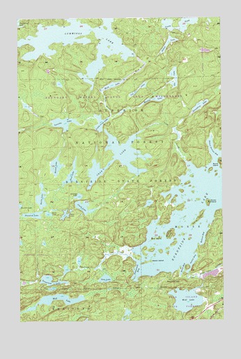
Crab Lake, MN USGS Topographic Map
Click on map above to begin viewing in our Map Viewer.

This topographic map contains these locations and features:
Feature Name Type Latitude Longitude GNIS ID View Map
Barefoot LakeLakeN47.9689°W92.0541°660559View Map
Battle LakeLakeN47.9262°W92.1112°660724View Map
Beach IslandIslandN47.8994°W92.0465°660729View Map
Burnt IslandIslandN47.9396°W92.0004°660916View Map
Burntside LakePopulated PlaceN47.8927°W92.0346°660919View Map
Burntside State ForestForestN47.9307°W92.1029°660921View Map
Clark LakeLakeN47.9222°W92.0851°661004View Map
Coo LakeLakeN47.9235°W92.0453°661041View Map
Coxey PondLakeN47.9983°W92.0238°661053View Map
Crab CreekStreamN47.9402°W92.0221°661055View Map
Crab LakeLakeN47.9425°W92.0633°661056View Map
Cummings LakeLakeN47.9910°W92.0947°661080View Map
Dollar IslandIslandN47.9235°W92.0088°661125View Map
Foss LakeLakeN47.8924°W92.0725°661308View Map
Geraldine LakeLakeN47.9633°W92.0137°661351View Map
Glimmer LakeLakeN47.9265°W92.0883°661367View Map
Hassel LakeLakeN47.9389°W92.1022°661437View Map
Hoist BayBayN47.8969°W92.0243°661482View Map
Jig LakeLakeN47.9722°W92.0478°661585View Map
Kaleva BayBayN47.9094°W92.0126°661612View Map
Korb LakeLakeN47.9723°W92.0669°661662View Map
Korb RiverStreamN47.9843°W92.0521°661663View Map
Little Crab LakeLakeN47.9568°W92.0745°661734View Map
Long IslandIslandN47.9169°W92.0149°661792View Map
Lunetta LakeLakeN47.9569°W92.0971°661839View Map
Maxine LakeLakeN47.9663°W92.0411°661882View Map
Meat LakeLakeN47.9188°W92.0961°661903View Map
Mud LakeLakeN47.8846°W92.1048°661996View Map
Nea Post Office (historical)Post OfficeN47.9806°W92.0083°2117827View Map
Ole LakeLakeN47.9732°W92.0303°662097View Map
Outlet BayBayN47.9002°W92.0185°662119View Map
Phantom LakeLakeN47.9190°W92.1160°662169View Map
Pine IslandIslandN47.9088°W92.0407°662198View Map
Princess LakeLakeN47.9634°W92.1196°660508View Map
Saca LakeLakeN47.9354°W92.0923°662317View Map
School Section BayBayN47.9435°W92.0013°662393View Map
Silaca LakeLakeN47.9893°W92.0323°662446View Map
Snellman IslandIslandN47.9107°W92.0324°662483View Map
Sprite LakeLakeN47.9194°W92.1069°662522View Map
Tamarack BayBayN47.8960°W92.0526°662622View Map
Tamarack CreekStreamN47.9010°W92.0549°662623View Map
Tamarack LakeLakeN47.8918°W92.1060°662624View Map
Tidbit LakeLakeN47.9728°W92.0994°660509View Map
Unorganized Territory of Crab Lake (historical)CensusN47.9310°W92.1180°2393270View Map
Wolf LakeLakeN47.8834°W92.0230°662823View Map

Note: Coordinates in the location and feature list above are referenced to NAD83 datum.


Copyright (C) 2008-2024 Ryan Niemi / Sunset Dynamics ... All Rights Reserved