TopoQuest Logo
Do you find TopoQuest useful?
Help keep TopoQuest running and adding new maps/features by donating!
Bitcoin:  19c7KJd3qBynnjoSw5npx9KScwjBe4ifkT
Litecoin:  LXs6TkuXGGXo1vDsWCkWVdjQX94eUKd6ui
Home View Maps Find Maps Find Places Resources & Links


Cravens, Arkansas Topographic Map

USGS Map Title: Cravens, AR
USGS Map MRC: 35093E8
DRG (GeoTIFF) Download: o35093e8.tif


Neighboring USGS Topographic Map Quads:


  Fern, AR  
35094F1
 

  Bidville, AR  
35093F8
 

  Cass, AR  
35093F7
 

  Mountainburg SE, AR  
35094E1
 

  Cravens, AR  
35093E8
 

  Watalula, AR  
35093E7
 

  Mulberry, AR  
35094D1
 

  Cecil, AR  
35093D8
 

  Ozark, AR  
35093D7


Map MRC Location:

N36°
W94°
N36°
W93°
H8 H7 H6 H5 H4 H3 H2 H1
G8 G7 G6 G5 G4 G3 G2 G1
F8 F7 F6 F5 F4 F3 F2 F1
E8 E7 E6 E5 E4 E3 E2 E1
D8 D7 D6 D5 D4 D3 D2 D1
C8 C7 C6 C5 C4 C3 C2 C1
B8 B7 B6 B5 B4 B3 B2 B1
A8 A7 A6 A5 A4 A3 A2 A1
N35°
W94°
N35°
W93°

Cravens, AR USGS 1:24K Topographic Map Preview:
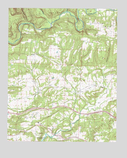
Cravens, AR USGS Topographic Map
Click on map above to begin viewing in our Map Viewer.

This topographic map contains these locations and features:
Feature Name Type Latitude Longitude GNIS ID View Map
Bourland CemeteryCemeteryN35.5465°W93.9235°70778View Map
Boyd MountainSummitN35.5479°W93.9952°70787View Map
Campbell CemeteryCemeteryN35.6245°W93.9102°70975View Map
Cedar CreekStreamN35.5173°W93.9277°71064View Map
CravensPopulated PlaceN35.5484°W93.9169°71275View Map
Cravens Church (historical)ChurchN35.5551°W93.8991°63004View Map
Cravens CreekStreamN35.5251°W93.9174°71276View Map
Deer Creek HollowValleyN35.6112°W93.9808°71360View Map
Dutchman HollowValleyN35.5681°W93.8913°71481View Map
Fairview ChurchChurchN35.5059°W93.9891°71576View Map
Fisher MountainSummitN35.5106°W93.9941°71616View Map
Franklin CountyCivilN35.5124°W93.8906°66853View Map
Ham FordCrossingN35.6209°W93.9005°63013View Map
Hamm CemeteryCemeteryN35.5484°W93.9644°71889View Map
Hixon CemeteryCemeteryN35.5070°W93.9002°72025View Map
Hurricane CreekStreamN35.6101°W93.9516°72124View Map
JethroPopulated PlaceN35.6076°W93.8874°72186View Map
Kings FordCrossingN35.6056°W93.9594°63014View Map
Lessley CemeteryCemeteryN35.5576°W93.9138°72308View Map
Lone ElmPopulated PlaceN35.5468°W93.9652°77540View Map
Lone Elm Gas FieldOilfieldN35.5304°W93.9594°72454View Map
Lone Oak School (historical)SchoolN35.5279°W93.8913°63016View Map
Middle Ridge School (historical)SchoolN35.5895°W93.9149°63018View Map
Oak Ridge CemeteryCemeteryN35.6117°W93.8930°72915View Map
Oak Ridge School (historical)SchoolN35.6109°W93.8933°63023View Map
Pleasant View Elementary SchoolSchoolN35.5174°W93.9652°63032View Map
Pleasant View High SchoolSchoolN35.5179°W93.9647°63033View Map
Pleasant View Volunteer Fire DepartmentBuildingN35.5185°W93.9631°2116986View Map
Possum Trot CreekStreamN35.5318°W93.9091°78079View Map
Rankin CemeteryCemeteryN35.5567°W93.9699°73237View Map
Salt Spring BendBendN35.6062°W93.9171°63036View Map
Threadgill CemeteryCemeteryN35.5529°W93.8988°73867View Map
ToneyPopulated PlaceN35.5181°W93.9627°73881View Map
Township of CravensCivilN35.5476°W93.9020°66547View Map
Township of MulberryCivilN35.5426°W93.9815°66560View Map
Township of WalkerCivilN35.6162°W93.8967°66564View Map
Township of White RockCivilN35.5907°W93.9673°66569View Map
Wagner CemeteryCemeteryN35.5270°W93.9849°73978View Map
White Oak Gas FieldOilfieldN35.5148°W93.8941°74119View Map
White RockPopulated PlaceN35.5818°W93.9694°78763View Map
Whitson CemeteryCemeteryN35.5256°W93.9094°74139View Map
Williams CemeteryCemeteryN35.5367°W93.8966°74158View Map

Note: Coordinates in the location and feature list above are referenced to NAD83 datum.


Copyright (C) 2008-2024 Ryan Niemi / Sunset Dynamics ... All Rights Reserved