TopoQuest Logo
Do you find TopoQuest useful?
Help keep TopoQuest running and adding new maps/features by donating!
Bitcoin:  19c7KJd3qBynnjoSw5npx9KScwjBe4ifkT
Litecoin:  LXs6TkuXGGXo1vDsWCkWVdjQX94eUKd6ui
Home View Maps Find Maps Find Places Resources & Links


Watalula, Arkansas Topographic Map

USGS Map Title: Watalula, AR
USGS Map MRC: 35093E7
DRG (GeoTIFF) Download: o35093e7.tif


Neighboring USGS Topographic Map Quads:


  Bidville, AR  
35093F8
 

  Cass, AR  
35093F7
 

  Yale, AR  
35093F6
 

  Cravens, AR  
35093E8
 

  Watalula, AR  
35093E7
 

  Hunt, AR  
35093E6
 

  Cecil, AR  
35093D8
 

  Ozark, AR  
35093D7
 

  Coal Hill, AR  
35093D6


Map MRC Location:

N36°
W94°
N36°
W93°
H8 H7 H6 H5 H4 H3 H2 H1
G8 G7 G6 G5 G4 G3 G2 G1
F8 F7 F6 F5 F4 F3 F2 F1
E8 E7 E6 E5 E4 E3 E2 E1
D8 D7 D6 D5 D4 D3 D2 D1
C8 C7 C6 C5 C4 C3 C2 C1
B8 B7 B6 B5 B4 B3 B2 B1
A8 A7 A6 A5 A4 A3 A2 A1
N35°
W94°
N35°
W93°

Watalula, AR USGS 1:24K Topographic Map Preview:
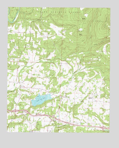
Watalula, AR USGS Topographic Map
Click on map above to begin viewing in our Map Viewer.

This topographic map contains these locations and features:
Feature Name Type Latitude Longitude GNIS ID View Map
Battle SpringsSpringN35.6022°W93.7871°70537View Map
Bell CemeteryCemeteryN35.5637°W93.8096°62994View Map
Belt ChapelChurchN35.5670°W93.8102°70619View Map
Burrell SpringSpringN35.6230°W93.8650°70936View Map
Carter MountainSummitN35.6073°W93.7557°71022View Map
Cripple BranchStreamN35.6190°W93.8546°71282View Map
Douglas MountainSummitN35.6140°W93.7857°71410View Map
Duncan BranchStreamN35.5434°W93.8627°71471View Map
Duncan CemeteryCemeteryN35.5590°W93.8505°71473View Map
Enon ChurchChurchN35.5806°W93.8580°71564View Map
Felkner TownPopulated PlaceN35.5495°W93.8605°63009View Map
Full Gospel TempleChurchN35.5115°W93.8194°71701View Map
Gar Creek ChurchChurchN35.5309°W93.7855°71726View Map
Handchew CemeteryCemeteryN35.6023°W93.7857°71895View Map
Harris CemeteryCemeteryN35.5948°W93.8313°71917View Map
Interchange 35CrossingN35.5212°W93.8649°58981View Map
Interchange 37CrossingN35.5151°W93.8191°58982View Map
Interstate 41CrossingN35.5051°W93.7577°58983View Map
Jethro ChurchChurchN35.5979°W93.8710°72187View Map
Low Gap ChurchChurchN35.5729°W93.7855°72506View Map
McLaughlin CemeteryCemeteryN35.6023°W93.8744°72611View Map
McNelly CemeteryCemeteryN35.5579°W93.8213°72617View Map
Mount EphraimSummitN35.5976°W93.7888°72748View Map
Mountain GrovePopulated PlaceN35.5354°W93.8055°72784View Map
Mountain Top ChurchChurchN35.5817°W93.7602°72792View Map
Mountain View CemeteryCemeteryN35.5326°W93.8099°77770View Map
New Hope School (historical)SchoolN35.5440°W93.7877°63021View Map
North Fork White Oak CreekStreamN35.5440°W93.8652°72892View Map
Ozark City LakeReservoirN35.5327°W93.8341°77301View Map
Ozark High SchoolSchoolN35.5033°W93.8655°63027View Map
Ozark Water Supply Lake DamDamN35.5301°W93.8452°80166View Map
Ozark-Franklin County AirportAirportN35.5088°W93.8401°74528View Map
Pleasant Grove Church (historical)ChurchN35.5409°W93.8277°63031View Map
Rock Creek FordCrossingN35.6217°W93.8619°63044View Map
Rock Creek Gas FieldOilfieldN35.6079°W93.7899°73345View Map
Roger CemeteryCemeteryN35.5984°W93.8271°73369View Map
Shiloh CemeteryCemeteryN35.5087°W93.7902°73543View Map
South Fork White Oak CreekStreamN35.5440°W93.8652°73653View Map
Sutherland CrossroadsPopulated PlaceN35.5348°W93.7708°73790View Map
Township of WatalulaCivilN35.5880°W93.8264°66566View Map
Township of White OakCivilN35.5160°W93.7910°66568View Map
WatalulaPopulated PlaceN35.5734°W93.8274°74016View Map
Watalula Volunteer Fire DepartmentBuildingN35.5343°W93.7929°2117276View Map
Westview CemeteryCemeteryN35.6009°W93.8085°74090View Map
Westview School (historical)SchoolN35.5998°W93.8085°63042View Map
White OakPopulated PlaceN35.5462°W93.8591°78748View Map
White Oak Gas FieldOilfieldN35.5237°W93.8321°74120View Map
Wildcat HollowValleyN35.5865°W93.7730°74152View Map

Note: Coordinates in the location and feature list above are referenced to NAD83 datum.


Copyright (C) 2008-2024 Ryan Niemi / Sunset Dynamics ... All Rights Reserved