TopoQuest Logo
Do you find TopoQuest useful?
Help keep TopoQuest running and adding new maps/features by donating!
Bitcoin:  19c7KJd3qBynnjoSw5npx9KScwjBe4ifkT
Litecoin:  LXs6TkuXGGXo1vDsWCkWVdjQX94eUKd6ui
Home View Maps Find Maps Find Places Resources & Links


Cravens, Kentucky Topographic Map

USGS Map Title: Cravens, KY
USGS Map MRC: 37085G5
DRG (GeoTIFF) Download: o37085g5.tif


Neighboring USGS Topographic Map Quads:


  Shepherdsville, KY  
37085H6
 

  Samuels, KY  
37085H5
 

  Fairfield, KY  
37085H4
 

  Lebanon Junction, KY  
37085G6
 

  Cravens, KY  
37085G5
 

  Bardstown, KY  
37085G4
 

  Nelsonville, KY  
37085F6
 

  New Haven, KY  
37085F5
 

  Loretto, KY  
37085F4


Map MRC Location:

N38°
W86°
N38°
W85°
H8 H7 H6 H5 H4 H3 H2 H1
G8 G7 G6 G5 G4 G3 G2 G1
F8 F7 F6 F5 F4 F3 F2 F1
E8 E7 E6 E5 E4 E3 E2 E1
D8 D7 D6 D5 D4 D3 D2 D1
C8 C7 C6 C5 C4 C3 C2 C1
B8 B7 B6 B5 B4 B3 B2 B1
A8 A7 A6 A5 A4 A3 A2 A1
N37°
W86°
N37°
W85°

Cravens, KY USGS 1:24K Topographic Map Preview:
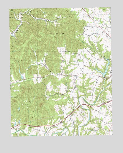
Cravens, KY USGS Topographic Map
Click on map above to begin viewing in our Map Viewer.

This topographic map contains these locations and features:
Feature Name Type Latitude Longitude GNIS ID View Map
Allens KnobSummitN37.7930°W85.6090°2742377View Map
BellwoodPopulated PlaceN37.7945°W85.5475°507492View Map
Boones CreekStreamN37.7843°W85.5186°2742380View Map
Boston DivisionCivilN37.7728°W85.6213°1936883View Map
Buffalo CreekStreamN37.7937°W85.5108°488314View Map
Cedar CreekStreamN37.7798°W85.5388°489175View Map
Cedar Creek Baptist ChurchChurchN37.7984°W85.5450°489186View Map
CravensPopulated PlaceN37.8087°W85.5427°507774View Map
Crutchers KnobSummitN37.7970°W85.5918°2742384View Map
Downs RunStreamN37.7906°W85.5651°2742385View Map
First Cedar Creek Baptist Church Historical MarkerParkN37.8088°W85.5426°2744629View Map
Flaget Memorial HospitalHospitalN37.8621°W85.5233°2660364View Map
Germantown HillSummitN37.8577°W85.5377°2742389View Map
Greene County Parachute Center AirportAirportN37.8153°W85.5394°517336View Map
Harrison CreekStreamN37.8690°W85.5994°493813View Map
Harts RunStreamN37.8634°W85.6116°493844View Map
HuntersPopulated PlaceN37.8603°W85.5011°508299View Map
Indian Grave RidgeRidgeN37.8490°W85.5630°494956View Map
Nelson ChurchChurchN37.8556°W85.5138°509477View Map
Overalls CreekStreamN37.8703°W85.6033°500050View Map
Ritchie KnobSummitN37.7598°W85.5156°2742404View Map
River BendBendN37.7565°W85.5563°2742406View Map
Rogers Station Historical MarkerParkN37.8110°W85.5344°2744622View Map
Smith HollowValleyN37.8730°W85.6215°503796View Map
Snake RunStreamN37.7520°W85.6058°503843View Map
Spooky HollowValleyN37.8059°W85.6095°504083View Map
Sutherland CemeteryCemeteryN37.7856°W85.5005°509478View Map
Sympson LakeReservoirN37.8109°W85.5123°504894View Map
Tewell CreekStreamN37.8040°W85.6055°505100View Map
Wolf Pen HollowValleyN37.8658°W85.6179°507026View Map

Note: Coordinates in the location and feature list above are referenced to NAD83 datum.


Copyright (C) 2008-2024 Ryan Niemi / Sunset Dynamics ... All Rights Reserved