TopoQuest Logo
Do you find TopoQuest useful?
Help keep TopoQuest running and adding new maps/features by donating!
Bitcoin:  19c7KJd3qBynnjoSw5npx9KScwjBe4ifkT
Litecoin:  LXs6TkuXGGXo1vDsWCkWVdjQX94eUKd6ui
Home View Maps Find Maps Find Places Resources & Links


Anna Maria, Florida Topographic Map

USGS Map Title: Anna Maria, FL
USGS Map MRC: 27082E6
DRG (GeoTIFF) Download: o27082e6.tif


Neighboring USGS Topographic Map Quads:


  Pass-a-Grille Beach, FL  
27082F6
 

  Cockroach Bay, FL  
27082F5
 

  Egmont Key, FL  
27082E7
 

  Anna Maria, FL  
27082E6
 

  Palmetto, FL  
27082E5


  Bradenton Beach, FL  
27082D6
 

  Bradenton, FL  
27082D5


Map MRC Location:

N28°
W83°
N28°
W82°
H8 H7 H6 H5 H4 H3 H2 H1
G8 G7 G6 G5 G4 G3 G2 G1
F8 F7 F6 F5 F4 F3 F2 F1
E8 E7 E6 E5 E4 E3 E2 E1
D8 D7 D6 D5 D4 D3 D2 D1
C8 C7 C6 C5 C4 C3 C2 C1
B8 B7 B6 B5 B4 B3 B2 B1
A8 A7 A6 A5 A4 A3 A2 A1
N27°
W83°
N27°
W82°

Anna Maria, FL USGS 1:24K Topographic Map Preview:
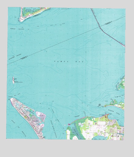
Anna Maria, FL USGS Topographic Map
Click on map above to begin viewing in our Map Viewer.

This topographic map contains these locations and features:
Feature Name Type Latitude Longitude GNIS ID View Map
Anna MariaPopulated PlaceN27.5311°W82.7334°277889View Map
Anna Maria Elementary SchoolSchoolN27.5027°W82.7115°298397View Map
Anna Maria IslandIslandN27.5142°W82.7190°293910View Map
Anna Maria Post OfficePost OfficeN27.5322°W82.7321°2783377View Map
Battery Bigelow (historical)MilitaryN27.6144°W82.7375°2105240View Map
Battery Laidley (historical)MilitaryN27.6153°W82.7361°2105239View Map
Bean PointCapeN27.5381°W82.7459°293923View Map
Bimini BayBayN27.5256°W82.7235°278783View Map
Bishop PointCapeN27.5198°W82.6334°293938View Map
City of Anna MariaCivilN27.5298°W82.7341°2403100View Map
City of Holmes BeachCivilN27.5109°W82.7153°2404720View Map
De Soto MonumentParkN27.6189°W82.7290°297452View Map
De Soto National MemorialParkN27.5227°W82.6434°294586View Map
De Soto PointCapeN27.6236°W82.7329°297453View Map
De Soto PointCapeN27.5253°W82.6409°293982View Map
Emerson BayouBayN27.5360°W82.6382°282197View Map
Emerson PointCapeN27.5323°W82.6468°294002View Map
Fort De SotoPopulated PlaceN27.6156°W82.7362°295291View Map
Fort De Soto ParkParkN27.6198°W82.7276°282682View Map
Holmes Beach Police DepartmentBuildingN27.5099°W82.7141°2333603View Map
Holmes Beach Post OfficePost OfficeN27.5055°W82.7154°2767976View Map
Jones BayouBayN27.5011°W82.7111°284902View Map
Key ROyale BarBarN27.5264°W82.7101°295083View Map
King Middle SchoolSchoolN27.5048°W82.6379°298385View Map
Manatee County BeachLocaleN27.5092°W82.7201°300015View Map
Manatee County Sheriff's Office District 5 Anna Maria UnitBuildingN27.5271°W82.7361°2333588View Map
Manatee RiverStreamN27.5309°W82.6534°286364View Map
Mead PointCapeN27.5139°W82.6818°294079View Map
Muller Key Channel Fishing Pier LightsLocaleN27.6136°W82.7398°297640View Map
Mullet KeyIslandN27.6192°W82.7240°294095View Map
Mullet Key ChannelChannelN27.6098°W82.6954°287459View Map
Mullet Key ShoalBarN27.6234°W82.6895°287460View Map
Northwest Baptist ChurchChurchN27.5064°W82.6411°2481743View Map
Palma SolaPopulated PlaceN27.5123°W82.6320°288420View Map
Palma Sola ChurchChurchN27.5070°W82.6479°288421View Map
Palma Sola Elementary SchoolSchoolN27.5040°W82.6313°298396View Map
Passage KeyIslandN27.5567°W82.7432°294115View Map
Passage Key InletBayN27.5453°W82.7326°288561View Map
Passage Key National Wildlife RefugeParkN27.5558°W82.7429°288562View Map
Passage Key WildernessReserveN27.5554°W82.7429°2768394View Map
Perico BayouBayN27.5047°W82.6739°288721View Map
Portavant Indian MoundSummitN27.5311°W82.6259°289242View Map
School KeyIslandN27.5225°W82.7123°290744View Map
Soldier HoleBayN27.6200°W82.7331°291324View Map
Terra Ceia PointCapeN27.5481°W82.6307°292130View Map
The BulkheadBarN27.5331°W82.7009°295084View Map
Warner West BayouLakeN27.5038°W82.6260°292889View Map
West Manatee Fire and Rescue DepartmentBuildingN27.5110°W82.7153°2481396View Map
West Manatee Fire and Rescue Station 3BuildingN27.5115°W82.7154°2131411View Map

Note: Coordinates in the location and feature list above are referenced to NAD83 datum.


Copyright (C) 2008-2024 Ryan Niemi / Sunset Dynamics ... All Rights Reserved