TopoQuest Logo
Do you find TopoQuest useful?
Help keep TopoQuest running and adding new maps/features by donating!
Bitcoin:  19c7KJd3qBynnjoSw5npx9KScwjBe4ifkT
Litecoin:  LXs6TkuXGGXo1vDsWCkWVdjQX94eUKd6ui
Home View Maps Find Maps Find Places Resources & Links


Bradenton Beach, Florida Topographic Map

USGS Map Title: Bradenton Beach, FL
USGS Map MRC: 27082D6
DRG (GeoTIFF) Download: o27082d6.tif


Neighboring USGS Topographic Map Quads:


  Egmont Key, FL  
27082E7
 

  Anna Maria, FL  
27082E6
 

  Palmetto, FL  
27082E5


  Bradenton Beach, FL  
27082D6
 

  Bradenton, FL  
27082D5


  Sarasota, FL  
27082C5


Map MRC Location:

N28°
W83°
N28°
W82°
H8 H7 H6 H5 H4 H3 H2 H1
G8 G7 G6 G5 G4 G3 G2 G1
F8 F7 F6 F5 F4 F3 F2 F1
E8 E7 E6 E5 E4 E3 E2 E1
D8 D7 D6 D5 D4 D3 D2 D1
C8 C7 C6 C5 C4 C3 C2 C1
B8 B7 B6 B5 B4 B3 B2 B1
A8 A7 A6 A5 A4 A3 A2 A1
N27°
W83°
N27°
W82°

Bradenton Beach, FL USGS 1:24K Topographic Map Preview:
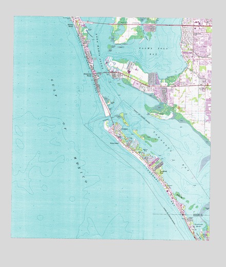
Bradenton Beach, FL USGS Topographic Map
Click on map above to begin viewing in our Map Viewer.

This topographic map contains these locations and features:
Feature Name Type Latitude Longitude GNIS ID View Map
Andrews Christian ChurchChurchN27.4600°W82.6609°303270View Map
Anna Maria BridgeBridgeN27.4964°W82.6943°303589View Map
Anna Maria SoundBayN27.4984°W82.6968°290682View Map
Bishops BayouBayN27.4327°W82.6811°278867View Map
Bradenton BeachPopulated PlaceN27.4670°W82.7040°279312View Map
Bradenton Beach Police DepartmentBuildingN27.4681°W82.6982°2333543View Map
Bradenton Beach Post OfficePost OfficeN27.4657°W82.6974°2768132View Map
Bradenton DivisionCivilN27.4765°W82.6274°1935702View Map
Buttonwood HarborBayN27.3822°W82.6314°279750View Map
Cedar Hammock Fire Rescue Station 3BuildingN27.4484°W82.6292°2644565View Map
City of Bradenton BeachCivilN27.4652°W82.6962°2403908View Map
Coon KeyIslandN27.4387°W82.6437°300026View Map
CortezPopulated PlaceN27.4692°W82.6862°280867View Map
Cortez BridgeBridgeN27.4689°W82.6937°280868View Map
Cortez Census Designated PlaceCensusN27.4668°W82.6688°2402798View Map
Cortez Post OfficePost OfficeN27.4688°W82.6831°2768199View Map
Cow PointCapeN27.4462°W82.6632°280942View Map
Cranes BayouBayN27.3751°W82.6295°281004View Map
Grassy PointCapeN27.4936°W82.7037°283331View Map
Grassy Point BayouBayN27.4928°W82.7039°283338View Map
Harris BayouBayN27.4217°W82.6668°283760View Map
Holmes BeachPopulated PlaceN27.4953°W82.7109°284190View Map
IlexhurstPopulated PlaceN27.4906°W82.7073°284469View Map
Island ChapelChurchN27.4239°W82.6693°284610View Map
Jewfish KeyIslandN27.4417°W82.6793°284797View Map
Lakeside PlazaLocaleN27.4623°W82.6332°296171View Map
Leffis KeyIslandN27.4523°W82.6890°285443View Map
LongbeachPopulated PlaceN27.4373°W82.6832°286082View Map
Longboat KeyIslandN27.3909°W82.6418°286083View Map
Longboat KeyPopulated PlaceN27.4125°W82.6590°286084View Map
Longboat Key Fire and Rescue DepartmentBuildingN27.4117°W82.6582°2481217View Map
Longboat Key Fire Rescue Station 1BuildingN27.4126°W82.6580°2131404View Map
Longboat Key Police DepartmentBuildingN27.4118°W82.6580°2333660View Map
Longboat PassBayN27.4439°W82.6876°286085View Map
Manatee County BeachBeachN27.4998°W82.7140°286353View Map
Manatee PlazaLocaleN27.4953°W82.6309°296168View Map
Millar BayBayN27.4258°W82.6653°286909View Map
Palma Sola BayBayN27.4829°W82.6595°294113View Map
Palma Sola Bay Baptist ChurchChurchN27.4663°W82.6365°2481749View Map
Palma Sola CreekStreamN27.4725°W82.6412°288422View Map
Palma Sola ParkPopulated PlaceN27.4917°W82.6368°288423View Map
Palma Sola Post OfficePost OfficeN27.4994°W82.6361°2768131View Map
Perico IslandIslandN27.4961°W82.6773°288722View Map
Prices KeyIslandN27.4836°W82.6893°289312View Map
Redeemer Lutheran ChurchChurchN27.4973°W82.6253°2481764View Map
Saint Bernards ChurchChurchN27.4995°W82.7115°290157View Map
Saints Peter and Paul the Apostles ChurchChurchN27.4756°W82.6380°2481793View Map
Sands PlazaLocaleN27.4753°W82.7248°296065View Map
Sister KeysIslandN27.4331°W82.6659°294153View Map
Tidy IslandIslandN27.4453°W82.6568°292264View Map
Town of Longboat KeyCivilN27.3912°W82.6355°2406041View Map
West Manatee Fire and Rescue Station 1BuildingN27.4968°W82.6282°2131482View Map
West Manatee Fire and Rescue Station 2BuildingN27.4623°W82.6649°2644566View Map
West Manatee Fire and Rescue Station 3BuildingN27.4665°W82.6977°2644567View Map
Whale KeyIslandN27.3937°W82.6282°294193View Map
White KeyIslandN27.3998°W82.6434°293207View Map
Whitney BeachPopulated PlaceN27.4298°W82.6804°295708View Map

Note: Coordinates in the location and feature list above are referenced to NAD83 datum.


Copyright (C) 2008-2024 Ryan Niemi / Sunset Dynamics ... All Rights Reserved