TopoQuest Logo
Do you find TopoQuest useful?
Help keep TopoQuest running and adding new maps/features by donating!
Bitcoin:  19c7KJd3qBynnjoSw5npx9KScwjBe4ifkT
Litecoin:  LXs6TkuXGGXo1vDsWCkWVdjQX94eUKd6ui
Home View Maps Find Maps Find Places Resources & Links


Creswell, North Carolina Topographic Map

USGS Map Title: Creswell, NC
USGS Map MRC: 35076G4
DRG (GeoTIFF) Download: o35076g4.tif


Neighboring USGS Topographic Map Quads:


  Roper North, NC  
35076H5
 

  Leonards Point, NC  
35076H4
 

  Columbia West, NC  
35076H3
 

  Roper South, NC  
35076G5
 

  Creswell, NC  
35076G4
 

  Creswell SE, NC  
35076G3
 

  Pungo Lake, NC  
35076F5
 

  New Lake NW, NC  
35076F4
 

  New Lake, NC  
35076F3


Map MRC Location:

N36°
W77°
N36°
W76°
H8 H7 H6 H5 H4 H3 H2 H1
G8 G7 G6 G5 G4 G3 G2 G1
F8 F7 F6 F5 F4 F3 F2 F1
E8 E7 E6 E5 E4 E3 E2 E1
D8 D7 D6 D5 D4 D3 D2 D1
C8 C7 C6 C5 C4 C3 C2 C1
B8 B7 B6 B5 B4 B3 B2 B1
A8 A7 A6 A5 A4 A3 A2 A1
N35°
W77°
N35°
W76°

Creswell, NC USGS 1:24K Topographic Map Preview:
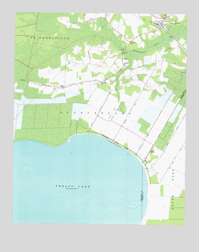
Creswell, NC USGS Topographic Map
Click on map above to begin viewing in our Map Viewer.

This topographic map contains these locations and features:
Feature Name Type Latitude Longitude GNIS ID View Map
Bee Tree OverlookLocaleN35.7741°W76.4005°1003100View Map
Bonarva CanalCanalN35.8127°W76.3777°981703View Map
CherryPopulated PlaceN35.8488°W76.4213°1019614View Map
Cherry Church of GodChurchN35.8453°W76.4201°2505937View Map
Concord ChurchChurchN35.8585°W76.4155°983434View Map
CreswellPopulated PlaceN35.8704°W76.3922°1019859View Map
Creswell Elementary SchoolSchoolN35.8698°W76.3967°1003412View Map
Creswell High SchoolSchoolN35.8686°W76.3955°1003413View Map
Creswell Methodist ChurchChurchN35.8704°W76.3922°1003426View Map
Creswell Post OfficePost OfficeN35.8702°W76.3952°2773994View Map
Creswell Volunteer Fire DepartmentBuildingN35.8695°W76.3944°2638370View Map
Galilee MissionPopulated PlaceN35.7932°W76.4002°1020391View Map
Lake Phelps Volunteer Fire DepartmentBuildingN35.8303°W76.4656°2638772View Map
Mall CreekStreamN35.8527°W76.4152°1003438View Map
Moccasin CanalCanalN35.8377°W76.4344°990113View Map
Mount Hermon ChurchChurchN35.8343°W76.4366°990406View Map
Mount TaborPopulated PlaceN35.8702°W76.4419°1021559View Map
Mount Tabor ChurchChurchN35.8699°W76.4422°1003441View Map
Mountain CanalCanalN35.8257°W76.4088°990685View Map
New LandsAreaN35.8471°W76.4852°1003442View Map
Ninefoot CanalCanalN35.8113°W76.4291°991155View Map
Pettigrew CemeteryCemeteryN35.7804°W76.3949°1003101View Map
Pettigrew State ParkParkN35.7971°W76.4219°992104View Map
Pettigrow State Park Information CenterBuildingN35.7971°W76.4219°1003445View Map
Pettigrow State Park OfficeBuildingN35.7971°W76.4219°1003446View Map
Phelps BridgeBridgeN35.8532°W76.4202°992115View Map
Phelps LakeLakeN35.7696°W76.4591°992118View Map
Philippi ChurchChurchN35.8452°W76.4202°992138View Map
Saint Davids ChurchChurchN35.8710°W76.3833°993880View Map
Saint Marys ChurchChurchN35.8513°W76.4216°994033View Map
Somerset Place State Historical SiteLocaleN35.7885°W76.4047°1003453View Map
Spruills BridgeBridgeN35.8618°W76.3844°995380View Map
Tenfoot CanalCanalN35.8168°W76.4277°995924View Map
Thirty-Foot CanalCanalN35.8279°W76.3852°996025View Map
Town of CreswellCivilN35.8702°W76.3924°2406336View Map
Township of ScuppernongCivilN35.8043°W76.4515°1027292View Map
Western CanalCanalN35.8210°W76.4347°997058View Map
Woodley ChapelChurchN35.8310°W76.4635°997601View Map

Note: Coordinates in the location and feature list above are referenced to NAD83 datum.


Copyright (C) 2008-2025 Ryan Niemi / Sunset Dynamics ... All Rights Reserved