TopoQuest Logo
Do you find TopoQuest useful?
Help keep TopoQuest running and adding new maps/features by donating!
Bitcoin:  19c7KJd3qBynnjoSw5npx9KScwjBe4ifkT
Litecoin:  LXs6TkuXGGXo1vDsWCkWVdjQX94eUKd6ui
Home View Maps Find Maps Find Places Resources & Links


Roper North, North Carolina Topographic Map

USGS Map Title: Roper North, NC
USGS Map MRC: 35076H5
DRG (GeoTIFF) Download: o35076h5.tif


Neighboring USGS Topographic Map Quads:


  Edenhouse, NC  
36076A6
 

  Edenton, NC  
36076A5
 

  Yeopim River, NC  
36076A4
 

  Westover, NC  
35076H6
 

  Roper North, NC  
35076H5
 

  Leonards Point, NC  
35076H4
 

  Plymouth East, NC  
35076G6
 

  Roper South, NC  
35076G5
 

  Creswell, NC  
35076G4


Map MRC Location:

N36°
W77°
N36°
W76°
H8 H7 H6 H5 H4 H3 H2 H1
G8 G7 G6 G5 G4 G3 G2 G1
F8 F7 F6 F5 F4 F3 F2 F1
E8 E7 E6 E5 E4 E3 E2 E1
D8 D7 D6 D5 D4 D3 D2 D1
C8 C7 C6 C5 C4 C3 C2 C1
B8 B7 B6 B5 B4 B3 B2 B1
A8 A7 A6 A5 A4 A3 A2 A1
N35°
W77°
N35°
W76°

Roper North, NC USGS 1:24K Topographic Map Preview:
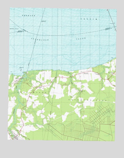
Roper North, NC USGS Topographic Map
Click on map above to begin viewing in our Map Viewer.

This topographic map contains these locations and features:
Feature Name Type Latitude Longitude GNIS ID View Map
Bakers SwampStreamN35.9218°W76.6144°1003420View Map
Batemans BeachBeachN35.9446°W76.5713°1003421View Map
BeasleyPopulated PlaceN35.9157°W76.5488°1019021View Map
Beaver Dam BranchStreamN35.8852°W76.6236°980805View Map
BlountPopulated PlaceN35.9166°W76.6005°1019222View Map
Chapel SwampStreamN35.9404°W76.5563°983027View Map
Hawkins BranchStreamN35.9349°W76.5516°1003433View Map
Holly Neck ChurchChurchN35.9224°W76.5399°986955View Map
Kendrick CreekStreamN35.9391°W76.6077°987916View Map
MackeysPopulated PlaceN35.9335°W76.6111°989213View Map
Mackeys CreekStreamN35.9388°W76.6074°1003436View Map
Mackeys Methodist ChurchChurchN35.9335°W76.6111°1003437View Map
Mill CreekStreamN35.8760°W76.6183°1003439View Map
Oak Grove ChurchChurchN35.9385°W76.5183°991388View Map
Old Court House (historical)BuildingN35.8763°W76.6197°1018708View Map
Old Mill CreekStreamN35.9104°W76.6116°1003443View Map
Pleasant GrovePopulated PlaceN35.9249°W76.5902°1022004View Map
Pleasant Grove Methodist ChurchChurchN35.9249°W76.5902°1003447View Map
RoperPopulated PlaceN35.8779°W76.6152°1022387View Map
Roper Methodist ChurchChurchN35.8779°W76.6152°1003450View Map
Roper Police DepartmentBuildingN35.8770°W76.6160°2130937View Map
Roper Post OfficePost OfficeN35.8783°W76.6157°2774279View Map
S Lees Saw MillsLocaleN35.8760°W76.6183°1003451View Map
Shiloh Wonder ChurchChurchN35.9393°W76.5027°994721View Map
SkinnersvillePopulated PlaceN35.9396°W76.5372°1022651View Map
Town of RoperCivilN35.8786°W76.6171°2407241View Map
Whites CreekStreamN35.9418°W76.5608°1003457View Map

Note: Coordinates in the location and feature list above are referenced to NAD83 datum.


Copyright (C) 2008-2025 Ryan Niemi / Sunset Dynamics ... All Rights Reserved