TopoQuest Logo
Do you find TopoQuest useful?
Help keep TopoQuest running and adding new maps/features by donating!
Bitcoin:  19c7KJd3qBynnjoSw5npx9KScwjBe4ifkT
Litecoin:  LXs6TkuXGGXo1vDsWCkWVdjQX94eUKd6ui
Home View Maps Find Maps Find Places Resources & Links


Creswell, Oregon Topographic Map

USGS Map Title: Creswell, OR
USGS Map MRC: 43123H1
DRG (GeoTIFF) Download: o43123h1.tif


Neighboring USGS Topographic Map Quads:


  Eugene West, OR  
44123A2
 

  Eugene East, OR  
44123A1
 

  Springfield, OR  
44122A8
 

  Fox Hollow, OR  
43123H2
 

  Creswell, OR  
43123H1
 

  Jasper, OR  
43122H8
 

  Lorane, OR  
43123G2
 

  Cottage Grove, OR  
43123G1
 

  Dorena Lake, OR  
43122G8


Map MRC Location:

N44°
W124°
N44°
W123°
H8 H7 H6 H5 H4 H3 H2 H1
G8 G7 G6 G5 G4 G3 G2 G1
F8 F7 F6 F5 F4 F3 F2 F1
E8 E7 E6 E5 E4 E3 E2 E1
D8 D7 D6 D5 D4 D3 D2 D1
C8 C7 C6 C5 C4 C3 C2 C1
B8 B7 B6 B5 B4 B3 B2 B1
A8 A7 A6 A5 A4 A3 A2 A1
N43°
W124°
N43°
W123°

Creswell, OR USGS 1:24K Topographic Map Preview:
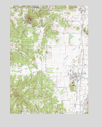
Creswell, OR USGS Topographic Map
Click on map above to begin viewing in our Map Viewer.

This topographic map contains these locations and features:
Feature Name Type Latitude Longitude GNIS ID View Map
52 & Willamette City ParkParkN43.9962°W123.1006°1987588View Map
Alvey SubstationLocaleN43.9993°W123.0162°1116899View Map
Art House Friends ChurchChurchN43.9006°W123.0383°2508137View Map
Camas SwaleValleyN43.9532°W123.0145°1118481View Map
Charlemagne at Fox Hollow French Immersion Elementary SchoolSchoolN43.9993°W123.0807°2462897View Map
Church of the NazareneChurchN43.9106°W123.0200°2508152View Map
City of CreswellCivilN43.9212°W123.0160°2410264View Map
Creslane Elementary SchoolSchoolN43.9205°W123.0286°1162284View Map
CreswellPopulated PlaceN43.9179°W123.0245°1119540View Map
Creswell Association CemeteryCemeteryN43.9076°W123.0567°1161629View Map
Creswell ButteSummitN43.9074°W123.0273°1119541View Map
Creswell City HallBuildingN43.9176°W123.0202°2661173View Map
Creswell DivisionCivilN43.9226°W123.0473°1937992View Map
Creswell High SchoolSchoolN43.9244°W123.0287°1162283View Map
Creswell Historical MuseumBuildingN43.9174°W123.0245°2661354View Map
Creswell LibraryBuildingN43.9184°W123.0196°2661603View Map
Creswell Middle SchoolSchoolN43.9170°W123.0266°1162285View Map
Creswell Post OfficePost OfficeN43.9195°W123.0170°1165108View Map
Creswell Sheriff's OfficeBuildingN43.9176°W123.0202°2770129View Map
Creswell Wastewater Treatment FacilityLocaleN43.9234°W123.0365°2660675View Map
Creswell Water TreatmentLocaleN43.9111°W123.0251°2660775View Map
Dillard Skyline City ParkParkN43.9985°W123.0623°1987594View Map
Fadeley ReservoirReservoirN43.8837°W123.1068°1160716View Map
Garden LakeReservoirN43.9226°W123.0095°1135749View Map
GoshenPopulated PlaceN43.9954°W123.0115°1136329View Map
Goshen Elementary SchoolSchoolN43.9947°W123.0083°1162282View Map
Goshen Grange 561 CemeteryCemeteryN43.9889°W123.0030°1130942View Map
Goshen Post Office (historical)Post OfficeN43.9954°W123.0115°1165330View Map
Goshen Rural Fire Protection DistrictBuildingN43.9956°W123.0108°2576769View Map
Hobby FieldAirportN43.9308°W123.0077°1131655View Map
Hult City ParkParkN43.9887°W123.0748°1166873View Map
Jackson Family CemeteryCemeteryN43.8757°W123.0428°1135180View Map
KPNW-AMTowerN43.9565°W123.0373°1131230View Map
Lane Transit District Park and RideLocaleN43.9174°W123.0197°2668115View Map
Mathews (historical)LocaleN43.9662°W123.0142°1166474View Map
Mazama Timber PadBuildingN43.9162°W123.0100°1131630View Map
Moxley CemeteryCemeteryN43.9304°W123.1192°1130941View Map
Pembrook ReservoirReservoirN43.8755°W123.1055°1130945View Map
Scott CreekStreamN43.9276°W123.0920°1130944View Map
South Lane County Fire and Rescue Station 2 - 3BuildingN43.9174°W123.0202°2576565View Map
Spencer ButteSummitN43.9830°W123.0958°1127382View Map
Spencer Butte ParkParkN43.9837°W123.0959°1135750View Map
Stalder SloughStreamN43.8762°W123.0123°1130943View Map
Tunnel MillraceCanalN43.8893°W123.0120°1128299View Map
Weyerhaeuser TimberLocaleN43.9897°W123.0103°2697285View Map

Note: Coordinates in the location and feature list above are referenced to NAD83 datum.


Copyright (C) 2008-2024 Ryan Niemi / Sunset Dynamics ... All Rights Reserved