TopoQuest Logo
Do you find TopoQuest useful?
Help keep TopoQuest running and adding new maps/features by donating!
Bitcoin:  19c7KJd3qBynnjoSw5npx9KScwjBe4ifkT
Litecoin:  LXs6TkuXGGXo1vDsWCkWVdjQX94eUKd6ui
Home View Maps Find Maps Find Places Resources & Links


Jasper, Oregon Topographic Map

USGS Map Title: Jasper, OR
USGS Map MRC: 43122H8
DRG (GeoTIFF) Download: o43122h8.tif


Neighboring USGS Topographic Map Quads:


  Eugene East, OR  
44123A1
 

  Springfield, OR  
44122A8
 

  Walterville, OR  
44122A7
 

  Creswell, OR  
43123H1
 

  Jasper, OR  
43122H8
 

  Lowell, OR  
43122H7
 

  Cottage Grove, OR  
43123G1
 

  Dorena Lake, OR  
43122G8
 

  Kloster Mountain, OR  
43122G7


Map MRC Location:

N44°
W123°
N44°
W122°
H8 H7 H6 H5 H4 H3 H2 H1
G8 G7 G6 G5 G4 G3 G2 G1
F8 F7 F6 F5 F4 F3 F2 F1
E8 E7 E6 E5 E4 E3 E2 E1
D8 D7 D6 D5 D4 D3 D2 D1
C8 C7 C6 C5 C4 C3 C2 C1
B8 B7 B6 B5 B4 B3 B2 B1
A8 A7 A6 A5 A4 A3 A2 A1
N43°
W123°
N43°
W122°

Jasper, OR USGS 1:24K Topographic Map Preview:
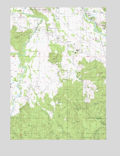
Jasper, OR USGS Topographic Map
Click on map above to begin viewing in our Map Viewer.

This topographic map contains these locations and features:
Feature Name Type Latitude Longitude GNIS ID View Map
Alder CreekStreamN43.9710°W122.8756°1116813View Map
Bear CreekStreamN43.9551°W122.9826°1117368View Map
Camas Swale CreekStreamN43.9548°W122.9909°1118483View Map
CloverdalePopulated PlaceN43.9248°W122.9673°1136159View Map
Cloverdale CemeteryCemeteryN43.9114°W122.9780°1119041View Map
Derr PondReservoirN43.9948°W122.9262°1163893View Map
DougrenLocaleN43.9632°W122.8840°1136230View Map
Emerald Christian AcademySchoolN43.9796°W122.9492°2462992View Map
Fall Creek JunctionLocaleN43.9846°W122.8890°1166254View Map
Hill CreekStreamN43.9354°W122.9867°1121833View Map
HillsLocaleN43.9782°W122.8787°1121838View Map
Hills CreekStreamN43.9962°W122.9073°1121839View Map
JasperPopulated PlaceN43.9965°W122.9062°1166666View Map
Jasper Bridge Boat RampLocaleN43.9983°W122.9062°2668133View Map
Jasper Post OfficePost OfficeN43.9976°W122.9038°1165450View Map
Jasper State ParkParkN43.9832°W122.9012°1162189View Map
Lane CountyCivilN43.9417°W122.8762°1135855View Map
Laurelwood AcademySchoolN43.9786°W122.8792°2463013View Map
Mulholland CemeteryCemeteryN43.9621°W122.9245°1130616View Map
Papenfus CreekStreamN43.9890°W122.9581°1134082View Map
Pleasant HillPopulated PlaceN43.9660°W122.9317°1125471View Map
Pleasant Hill CemeteryCemeteryN43.9623°W122.9192°1130615View Map
Pleasant Hill Church of ChristChurchN43.9653°W122.9294°2508143View Map
Pleasant Hill Community TheatreBuildingN43.9808°W122.9492°2661576View Map
Pleasant Hill DivisionCivilN43.9487°W122.9298°1938094View Map
Pleasant Hill High SchoolSchoolN43.9571°W122.9159°2463027View Map
Pleasant Hill Lutheran ChurchChurchN43.9575°W122.9106°2508144View Map
Pleasant Hill Middle SchoolSchoolN43.9571°W122.9160°2463028View Map
Pleasant Hill Post OfficePost OfficeN43.9703°W122.9368°1165797View Map
Pleasant Hill Volunteer Fire Protection District Station 1BuildingN43.9660°W122.9311°2576973View Map
Pleasant Hill Volunteer Fire Protection District Station 2BuildingN43.9980°W122.9043°2576993View Map
Rattlesnake ButteSummitN43.9369°W122.8862°1125817View Map
Rattlesnake CreekStreamN43.9762°W122.8892°1158439View Map
Robberson ReservoirReservoirN43.9721°W122.9347°1163892View Map
Sellers ButteSummitN43.9512°W122.9424°1126735View Map
Sellers CemeteryCemeteryN43.9493°W122.9508°1130614View Map
Short MountainSummitN43.9707°W122.9910°1126920View Map
Short Mountain Power PlantLocaleN43.9620°W122.9973°2697281View Map
Wild Hog CreekStreamN43.9943°W122.9984°1160732View Map

Note: Coordinates in the location and feature list above are referenced to NAD83 datum.


Copyright (C) 2008-2025 Ryan Niemi / Sunset Dynamics ... All Rights Reserved