TopoQuest Logo
Do you find TopoQuest useful?
Help keep TopoQuest running and adding new maps/features by donating!
Bitcoin:  19c7KJd3qBynnjoSw5npx9KScwjBe4ifkT
Litecoin:  LXs6TkuXGGXo1vDsWCkWVdjQX94eUKd6ui
Home View Maps Find Maps Find Places Resources & Links


Crewe West, Virginia Topographic Map

USGS Map Title: Crewe West, VA
USGS Map MRC: 37078B2
DRG (GeoTIFF) Download: o37078b2.tif


Neighboring USGS Topographic Map Quads:


  Rice, VA  
37078C3
 

  Deatonville, VA  
37078C2
 

  Jetersville, VA  
37078C1
 

  Green Bay, VA  
37078B3
 

  Crewe West, VA  
37078B2
 

  Crewe East, VA  
37078B1
 

  Meherrin, VA  
37078A3
 

  Rubermont, VA  
37078A2
 

  Blackstone West, VA  
37078A1


Map MRC Location:

N38°
W79°
N38°
W78°
H8 H7 H6 H5 H4 H3 H2 H1
G8 G7 G6 G5 G4 G3 G2 G1
F8 F7 F6 F5 F4 F3 F2 F1
E8 E7 E6 E5 E4 E3 E2 E1
D8 D7 D6 D5 D4 D3 D2 D1
C8 C7 C6 C5 C4 C3 C2 C1
B8 B7 B6 B5 B4 B3 B2 B1
A8 A7 A6 A5 A4 A3 A2 A1
N37°
W79°
N37°
W78°

Crewe West, VA USGS 1:24K Topographic Map Preview:
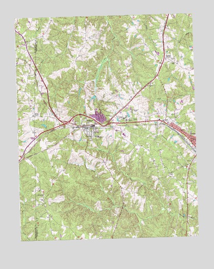
Crewe West, VA USGS Topographic Map
Click on map above to begin viewing in our Map Viewer.

This topographic map contains these locations and features:
Feature Name Type Latitude Longitude GNIS ID View Map
Baker Memorial ChurchChurchN37.1865°W78.1994°1462701View Map
Burkes TavernPopulated PlaceN37.1949°W78.2383°1477159View Map
BurkevillePopulated PlaceN37.1877°W78.2014°1464115View Map
Burkeville Elementary SchoolSchoolN37.1824°W78.1934°1493904View Map
Burkeville Police DepartmentBuildingN37.1871°W78.2010°2331935View Map
Burkeville Post OfficePost OfficeN37.1863°W78.2010°2766167View Map
Burkeville Volunteer Fire and Rescue DepartmentBuildingN37.1881°W78.2080°2075300View Map
Carys CreekStreamN37.1415°W78.1492°1464510View Map
Cook CemeteryCemeteryN37.2379°W78.1961°1493906View Map
Crewe CemeteryCemeteryN37.1677°W78.1264°1493909View Map
Crewe Volunteer Fire DepartmentBuildingN37.1843°W78.1377°2075299View Map
District 1CivilN37.1383°W78.1501°1927187View Map
Downs CemeteryCemeteryN37.2238°W78.1397°1465930View Map
Engleside Elementary SchoolSchoolN37.1824°W78.1933°1468503View Map
First Nottoway ChurchChurchN37.2104°W78.1558°1466591View Map
Hickory Grove ChurchChurchN37.1932°W78.1422°1467982View Map
Hickory Grove School (historical)SchoolN37.1946°W78.1300°1493922View Map
Jennings OrdinaryPopulated PlaceN37.2254°W78.1456°1493142View Map
Lush DamDamN37.2035°W78.1964°1490515View Map
Macedonia ChurchChurchN37.1854°W78.1964°1469972View Map
Mallorys CreekStreamN37.1418°W78.1497°1477036View Map
Morning Star ChurchChurchN37.1504°W78.2328°1470743View Map
MuttPopulated PlaceN37.1899°W78.1719°1493332View Map
Nottaway Correctional CenterBuildingN37.1832°W78.1753°2741365View Map
Olive Branch CemeteryCemeteryN37.1943°W78.1822°1471898View Map
Oliver CemeteryCemeteryN37.1474°W78.2330°1471908View Map
OlivevillePopulated PlaceN37.1474°W78.2331°1493930View Map
Piedmont Geriatric HospitalHospitalN37.1924°W78.1749°1472282View Map
Piedmont State Hospital DamDamN37.1935°W78.1714°1490514View Map
Sunset Hill CemeteryCemeteryN37.1888°W78.2153°1475340View Map
Thomas CemeteryCemeteryN37.1338°W78.2383°1493942View Map
Town of BurkevilleCivilN37.1879°W78.2012°2390761View Map
Town of CreweCivilN37.1812°W78.1306°2390816View Map
Union ChurchChurchN37.1607°W78.1433°1476045View Map
Vaughns CemeteryCemeteryN37.2060°W78.1842°1476164View Map
Wards ChapelChurchN37.2229°W78.1403°1476312View Map
Wards Chapel CemeteryCemeteryN37.2232°W78.1411°1493944View Map
Watkins School (historical)SchoolN37.1610°W78.1444°1493945View Map
Wesleyan ChurchChurchN37.1852°W78.1356°1476466View Map
WSVS-AM (Crewe)TowerN37.1954°W78.1667°1498930View Map
WSVS-FM (Crewe)TowerN37.1954°W78.1667°1498979View Map
Yielding Zion ChurchChurchN37.1827°W78.1981°1474346View Map

Note: Coordinates in the location and feature list above are referenced to NAD83 datum.


Copyright (C) 2008-2024 Ryan Niemi / Sunset Dynamics ... All Rights Reserved