TopoQuest Logo
Do you find TopoQuest useful?
Help keep TopoQuest running and adding new maps/features by donating!
Bitcoin:  19c7KJd3qBynnjoSw5npx9KScwjBe4ifkT
Litecoin:  LXs6TkuXGGXo1vDsWCkWVdjQX94eUKd6ui
Home View Maps Find Maps Find Places Resources & Links


Crystal Crag, California Topographic Map

USGS Map Title: Crystal Crag, CA
USGS Map MRC: 37119E1
DRG (GeoTIFF) Download: o37119e1.tif


Neighboring USGS Topographic Map Quads:


  Mount Ritter, CA  
37119F2
 

  Mammoth Mountain, CA  
37119F1
 

  Old Mammoth, CA  
37118F8
 

  Cattle Mountain, CA  
37119E2
 

  Crystal Crag, CA  
37119E1
 

  Bloody Mountain, CA  
37118E8
 

  Balloon Dome, CA  
37119D2
 

  Sharktooth Peak, CA  
37119D1
 

  Graveyard Peak, CA  
37118D8


Map MRC Location:

N38°
W120°
N38°
W119°
H8 H7 H6 H5 H4 H3 H2 H1
G8 G7 G6 G5 G4 G3 G2 G1
F8 F7 F6 F5 F4 F3 F2 F1
E8 E7 E6 E5 E4 E3 E2 E1
D8 D7 D6 D5 D4 D3 D2 D1
C8 C7 C6 C5 C4 C3 C2 C1
B8 B7 B6 B5 B4 B3 B2 B1
A8 A7 A6 A5 A4 A3 A2 A1
N37°
W120°
N37°
W119°

Crystal Crag, CA USGS 1:24K Topographic Map Preview:
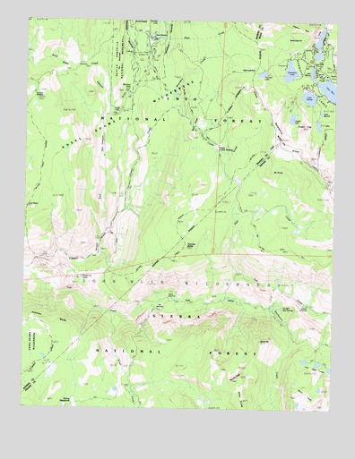
Crystal Crag, CA USGS Topographic Map
Click on map above to begin viewing in our Map Viewer.

This topographic map contains these locations and features:
Feature Name Type Latitude Longitude GNIS ID View Map
Bench LakesLakeN37.5017°W119.0143°252176View Map
Bottomless PitBasinN37.6191°W119.0187°1702742View Map
Bottomless PitArchN37.6194°W119.0114°2726168View Map
Boundary CreekStreamN37.6044°W119.0826°257389View Map
Cold CreekStreamN37.5560°W119.0935°258525View Map
Crater CreekStreamN37.5577°W119.0924°258883View Map
Crystal CragSummitN37.5910°W119.0137°258955View Map
Crystal LakeLakeN37.5939°W119.0184°258959View Map
Deer CreekStreamN37.5438°W119.0393°259215View Map
Devils PostpileCliffN37.6244°W119.0818°259326View Map
Devils Postpile National MonumentParkN37.6154°W119.0877°266641View Map
Devils TopSummitN37.5216°W119.0301°259333View Map
Double PeakSummitN37.5105°W119.0373°259509View Map
Dragons BackRidgeN37.6241°W119.0196°1702744View Map
Fish ValleyValleyN37.5291°W119.0829°260161View Map
Fox MeadowFlatN37.5324°W119.0707°1702729View Map
Horseshoe LakeLakeN37.6088°W119.0194°261529View Map
Horseshoe Lake Group CampgroundLocaleN37.6099°W119.0219°2547626View Map
Horseshoe Lake Picnic SiteLocaleN37.6129°W119.0203°2547627View Map
Island CrossingCrossingN37.5349°W119.0682°1656096View Map
Iva Bell Hot SpringsSpringN37.5304°W119.0320°260151View Map
Junction BluffsCliffN37.5313°W119.1162°262042View Map
King CreekStreamN37.6013°W119.0918°262179View Map
Lake BarrettLakeN37.5956°W119.0067°256556View Map
Lake GeorgeLakeN37.6005°W119.0118°260527View Map
Lake George CampgroundLocaleN37.6026°W119.0099°2547636View Map
Lake George Picnic SiteLocaleN37.6034°W119.0105°2547637View Map
Lake MamieLakeN37.6083°W119.0104°263137View Map
Lake MaryPopulated PlaceN37.5999°W119.0012°252300View Map
Lake MaryLakeN37.6029°W119.0028°263249View Map
Lake Mary CampgroundLocaleN37.6069°W119.0068°2547638View Map
Lake Mary Post Office (historical)Post OfficeN37.5999°W119.0012°1940061View Map
Lion PointSummitN37.5652°W119.1246°262501View Map
Lost Keys LakesLakeN37.5156°W119.0117°262943View Map
Lower Rainbow FallsFallsN37.5944°W119.0890°263037View Map
Mammoth LakesLakeN37.6047°W119.0112°263142View Map
Mammoth Mountain-Bottomless Pit TrailheadLocaleN37.6155°W119.0111°2547649View Map
Mammoth PassGapN37.6094°W119.0340°263146View Map
Mammoth Pass TrailheadLocaleN37.6130°W119.0207°2547650View Map
McCloud LakeLakeN37.6081°W119.0306°263317View Map
McLeod LakeLakeN37.6081°W119.0306°274662View Map
Panorama DomeSummitN37.6191°W119.0007°1812844View Map
Panorama Dome TrailheadLocaleN37.6205°W119.0047°2547678View Map
Pond Lily LakeLakeN37.5421°W119.1025°264920View Map
Pumice ButteSummitN37.5519°W119.0607°265058View Map
Rainbow FallsFallsN37.6016°W119.0835°265140View Map
Rainbow Falls TrailheadLocaleN37.6139°W119.0766°2547686View Map
Red ConesSummitN37.5885°W119.0579°265263View Map
Reds CreekStreamN37.6160°W119.0835°265341View Map
Reds MeadowFlatN37.6199°W119.0754°1702737View Map
Reds Meadow CampgroundLocaleN37.6194°W119.0743°276509View Map
Reds Meadow Hot SpringsSpringN37.6180°W119.0732°265343View Map
Reds Meadow Ranger StationLocaleN37.6191°W119.0718°265344View Map
Second CrossingCrossingN37.5336°W119.0126°1656282View Map
Sharktooth CreekStreamN37.5363°W119.0440°266045View Map
Silver CreekStreamN37.5302°W119.0915°266178View Map
Snow CanyonValleyN37.6016°W119.0918°267311View Map
Summit MeadowFlatN37.5991°W119.1218°267941View Map
T J LakeLakeN37.5917°W119.0077°268045View Map
Tamarack Cross Country Ski CenterLocaleN37.6185°W119.0065°1812851View Map
The ButtressesCliffN37.6116°W119.0868°268178View Map
The ThumbPillarN37.5766°W119.0260°268212View Map
Twin FallsFallsN37.6116°W119.0101°1702747View Map
Twin Falls Picnic SiteLocaleN37.6106°W119.0094°2547577View Map
Twin LakesLakeN37.6180°W119.0083°268523View Map
Twin Lakes CampgroundLocaleN37.6160°W119.0097°2547578View Map
Twin Lakes Picnic SiteLocaleN37.6155°W119.0067°2547579View Map
Twin Lakes VistaLocaleN37.6240°W119.0063°2547580View Map

Note: Coordinates in the location and feature list above are referenced to NAD83 datum.


Copyright (C) 2008-2024 Ryan Niemi / Sunset Dynamics ... All Rights Reserved