TopoQuest Logo
Do you find TopoQuest useful?
Help keep TopoQuest running and adding new maps/features by donating!
Bitcoin:  19c7KJd3qBynnjoSw5npx9KScwjBe4ifkT
Litecoin:  LXs6TkuXGGXo1vDsWCkWVdjQX94eUKd6ui
Home View Maps Find Maps Find Places Resources & Links


Old Mammoth, California Topographic Map

USGS Map Title: Old Mammoth, CA
USGS Map MRC: 37118F8
DRG (GeoTIFF) Download: o37118f8.tif


Neighboring USGS Topographic Map Quads:


  June Lake, CA  
37119G1
 

  Crestview, CA  
37118G8
 

  Dexter Canyon, CA  
37118G7
 

  Mammoth Mountain, CA  
37119F1
 

  Old Mammoth, CA  
37118F8
 

  Whitmore Hot Springs, CA  
37118F7
 

  Crystal Crag, CA  
37119E1
 

  Bloody Mountain, CA  
37118E8
 

  Convict Lake, CA  
37118E7


Map MRC Location:

N38°
W119°
N38°
W118°
H8 H7 H6 H5 H4 H3 H2 H1
G8 G7 G6 G5 G4 G3 G2 G1
F8 F7 F6 F5 F4 F3 F2 F1
E8 E7 E6 E5 E4 E3 E2 E1
D8 D7 D6 D5 D4 D3 D2 D1
C8 C7 C6 C5 C4 C3 C2 C1
B8 B7 B6 B5 B4 B3 B2 B1
A8 A7 A6 A5 A4 A3 A2 A1
N37°
W119°
N37°
W118°

Old Mammoth, CA USGS 1:24K Topographic Map Preview:
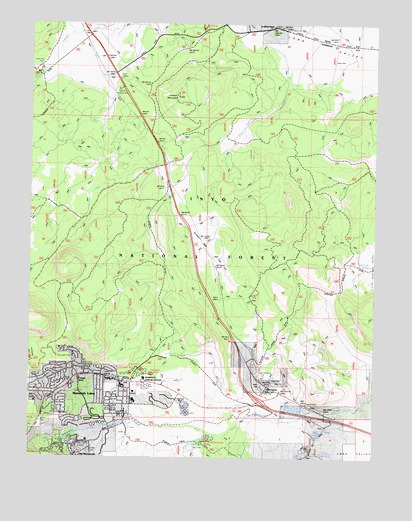
Old Mammoth, CA USGS Topographic Map
Click on map above to begin viewing in our Map Viewer.

This topographic map contains these locations and features:
Feature Name Type Latitude Longitude GNIS ID View Map
Antelope SpringSpringN37.6804°W118.8773°1667691View Map
Arcularius RanchLocaleN37.7491°W118.9143°256314View Map
Big Springs CampgroundLocaleN37.7486°W118.9392°257019View Map
Camp High SierraLocaleN37.6383°W118.9921°257882View Map
Casa Diablo Hot SpringsLocaleN37.6463°W118.9160°258026View Map
Community Center ParkParkN37.6524°W118.9840°1812897View Map
Crestview Roadside RestLocaleN37.7310°W118.9690°1667696View Map
Dry CreekStreamN37.7494°W118.9163°259549View Map
Dry Creek KnollSummitN37.6780°W118.9860°274727View Map
Earthquake DomeSummitN37.6663°W118.9999°274726View Map
Earthquake Flat Interpretive SiteLocaleN37.6539°W118.9998°2547612View Map
Gilbert PeakSummitN37.6988°W118.9065°274729View Map
Glass CreekStreamN37.7472°W118.9865°271304View Map
Laurel CreekStreamN37.6327°W118.8912°262353View Map
Long Valley CalderaCraterN37.7166°W118.8843°274650View Map
Lookout MountainSummitN37.7288°W118.9476°262899View Map
Main Street Plaza Shopping CenterLocaleN37.6472°W118.9687°1812898View Map
Mammoth AmphitheaterBuildingN37.6408°W118.9581°2547646View Map
Mammoth Business ParkLocaleN37.6422°W118.9524°1812899View Map
Mammoth CreekStreamN37.6394°W118.9079°263140View Map
Mammoth Creek ParkParkN37.6352°W118.9668°1812900View Map
Mammoth Factory Store Shopping CenterLocaleN37.6474°W118.9712°1812901View Map
Mammoth Gateway Center Shopping CenterLocaleN37.6466°W118.9665°1812902View Map
Mammoth High SchoolSchoolN37.6414°W118.9629°1812903View Map
Mammoth HospitalHospitalN37.6438°W118.9630°1812904View Map
Mammoth KnollsSummitN37.6588°W118.9790°274728View Map
Mammoth LakesPopulated PlaceN37.6485°W118.9721°1659042View Map
Mammoth Lakes Fire Protection District Station 1 HeadquartersBuildingN37.6477°W118.9678°2624275View Map
Mammoth Lakes Fire Protection District Station 2BuildingN37.6298°W118.9781°2624227View Map
Mammoth Lakes Police DepartmentBuildingN37.6378°W118.9671°2755897View Map
Mammoth Lakes Post OfficePost OfficeN37.6490°W118.9709°1667701View Map
Mammoth Mall Shopping CenterLocaleN37.6444°W118.9668°1812906View Map
Mammoth Mountain Recreation Vehicle ParkLocaleN37.6452°W118.9582°1812907View Map
Mammoth MuseumBuildingN37.6349°W118.9646°1812908View Map
Mammoth Public LibraryBuildingN37.6524°W118.9837°1812909View Map
Mammoth Ranger StationLocaleN37.6479°W118.9642°263148View Map
Mammoth Visitor CenterBuildingN37.6477°W118.9590°1667702View Map
Mammoth Visitor Center Picnic SiteLocaleN37.6475°W118.9602°2547651View Map
Minaret Village Mall Shopping CenterLocaleN37.6397°W118.9657°1812910View Map
Mono County Paramedics Station 3BuildingN37.6480°W118.9681°2662241View Map
Old MammothPopulated PlaceN37.6260°W118.9832°1667705View Map
Old Shady Rest CampgroundLocaleN37.6488°W118.9654°1667706View Map
Pine Glen Group CampgroundLocaleN37.6491°W118.9562°1667707View Map
Red Rooster Mall Shopping CenterLocaleN37.6477°W118.9726°1812912View Map
Saint Joseph ChurchChurchN37.6477°W118.9837°265742View Map
Shady Rest CampgroundLocaleN37.6502°W118.9601°275872View Map
Shady Rest ParkParkN37.6541°W118.9554°1812913View Map
Shell Center Shopping CenterLocaleN37.6463°W118.9649°1812914View Map
Sherwin CreekStreamN37.6324°W118.9376°267239View Map
Sherwin Creek CampgroundLocaleN37.6299°W118.9360°275873View Map
Sherwin Creek Picnic SiteLocaleN37.6286°W118.9403°2547703View Map
Sherwin Plaza Shopping CenterLocaleN37.6369°W118.9657°1812915View Map
Sherwin Professional PlazaLocaleN37.6383°W118.9657°1812916View Map
Sierra Center Mall Shopping CenterLocaleN37.6397°W118.9668°1812917View Map
Sierra High SchoolSchoolN37.6410°W118.9621°1812918View Map
Sierra Meadows RanchLocaleN37.6333°W118.9640°1812919View Map
Smokey Bear FlatFlatN37.6860°W118.9374°1667710View Map
Snowcreek Athletic ClubLocaleN37.6299°W118.9796°1812920View Map
Snowcreek Driving RangeLocaleN37.6327°W118.9699°1812921View Map
Snowcreek Golf CourseLocaleN37.6308°W118.9732°1812922View Map
Town of Mammoth LakesCivilN37.6273°W118.9899°2412936View Map
United States Forest Service Mammoth Lakes Ranger StationBuildingN37.6468°W118.9591°2623960View Map
Valentine Reserve Ecological Study AreaParkN37.6285°W118.9960°1812923View Map
White Wing CampLocaleN37.7369°W118.9974°275816View Map

Note: Coordinates in the location and feature list above are referenced to NAD83 datum.


Copyright (C) 2008-2024 Ryan Niemi / Sunset Dynamics ... All Rights Reserved