TopoQuest Logo
Do you find TopoQuest useful?
Help keep TopoQuest running and adding new maps/features by donating!
Bitcoin:  19c7KJd3qBynnjoSw5npx9KScwjBe4ifkT
Litecoin:  LXs6TkuXGGXo1vDsWCkWVdjQX94eUKd6ui
Home View Maps Find Maps Find Places Resources & Links


Currie, North Carolina Topographic Map

USGS Map Title: Currie, NC
USGS Map MRC: 34078D1
DRG (GeoTIFF) Download: o34078d1.tif


Neighboring USGS Topographic Map Quads:


  Atkinson, NC  
34078E2
 

  Costin, NC  
34078E1
 

  Burgaw, NC  
34077E8
 

  Point Caswell, NC  
34078D2
 

  Currie, NC  
34078D1
 

  Rocky Point, NC  
34077D8
 

  Acme, NC  
34078C2
 

  Leland, NC  
34078C1
 

  Castle Hayne, NC  
34077C8


Map MRC Location:

N35°
W79°
N35°
W78°
H8 H7 H6 H5 H4 H3 H2 H1
G8 G7 G6 G5 G4 G3 G2 G1
F8 F7 F6 F5 F4 F3 F2 F1
E8 E7 E6 E5 E4 E3 E2 E1
D8 D7 D6 D5 D4 D3 D2 D1
C8 C7 C6 C5 C4 C3 C2 C1
B8 B7 B6 B5 B4 B3 B2 B1
A8 A7 A6 A5 A4 A3 A2 A1
N34°
W79°
N34°
W78°

Currie, NC USGS 1:24K Topographic Map Preview:
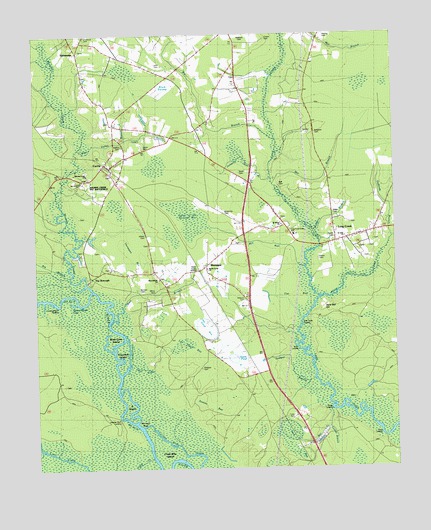
Currie, NC USGS Topographic Map
Click on map above to begin viewing in our Map Viewer.

This topographic map contains these locations and features:
Feature Name Type Latitude Longitude GNIS ID View Map
Bear BranchStreamN34.4174°W78.0997°980691View Map
Bear Branch ChurchChurchN34.4299°W78.0822°980700View Map
Bell CemeteryCemeteryN34.4560°W78.0397°980932View Map
Big BranchStreamN34.4668°W78.0414°1025144View Map
Birds Cove IslandIslandN34.4129°W78.0958°981502View Map
Black Swamp (historical)SwampN34.4843°W78.0822°1025161View Map
Brinson CemeteryCemeteryN34.4271°W78.0894°981913View Map
Browning CemeteryCemeteryN34.4488°W78.0592°982024View Map
Buckle Swamp CreekStreamN34.3802°W78.1242°1025198View Map
Burnt LandingLocaleN34.4110°W78.0353°1019426View Map
Cane CreekStreamN34.4054°W78.0919°982585View Map
Chadwick CemeteryCemeteryN34.4988°W78.1094°982984View Map
Collins BranchStreamN34.3871°W78.0230°983381View Map
Croom CemeteryCemeteryN34.4990°W78.0444°983777View Map
Cross Way CreekGutN34.3788°W78.0672°983794View Map
Cross Way IslandIslandN34.3810°W78.0811°1025271View Map
Cunning Bluff LandingLocaleN34.4221°W78.1178°1019885View Map
CurriePopulated PlaceN34.4627°W78.1011°983853View Map
Currie Post OfficePost OfficeN34.4634°W78.1004°2505352View Map
Currie SchoolSchoolN34.4724°W78.0830°983855View Map
Curve of the Railroad BaySwampN34.4474°W78.0712°983863View Map
Cypress Grove Mobile Home ParkPopulated PlaceN34.4878°W78.0527°2505449View Map
D IslandIslandN34.3960°W78.0947°983909View Map
Deer Valley BranchStreamN34.4657°W78.1100°984116View Map
Dick Taylor LandingLocaleN34.4185°W78.0308°1019965View Map
Ditch BaySwampN34.4146°W78.0672°984207View Map
Ditch LandingLocaleN34.3846°W78.0050°1019977View Map
E and H Mobile Home ParkPopulated PlaceN34.3897°W78.0357°2505462View Map
Flat BaySwampN34.4260°W78.0353°985152View Map
Garrisons CemeteryCemeteryN34.4424°W78.0208°1025333View Map
Goose PondSwampN34.4079°W78.0575°985829View Map
Grady Monument parkParkN34.4568°W78.1131°1003301View Map
Guffords BranchStreamN34.4410°W78.0005°1025360View Map
Hedden Bluff LandingLocaleN34.3896°W78.0969°1025378View Map
Henry CemeteryCemeteryN34.4413°W78.0214°986620View Map
Herrings NeckCapeN34.3871°W78.0889°986664View Map
History TrailTrailN34.4579°W78.1056°1003300View Map
Horsepen BaySwampN34.4352°W78.0886°987123View Map
Isom CemeteryCemeteryN34.4379°W78.0067°987437View Map
Jack BayBasinN34.3849°W78.0372°1025065View Map
Jumping Run BranchStreamN34.4588°W78.0433°1025438View Map
Juniper BranchStreamN34.4074°W78.0328°987835View Map
Lamb CemeteryCemeteryN34.4907°W78.0805°988107View Map
Larkins CemeteryCemeteryN34.4374°W78.0117°988149View Map
Lee DitchStreamN34.4721°W78.0858°988298View Map
Lee Hugh BaySwampN34.4108°W78.0739°988299View Map
Lewis BranchStreamN34.4704°W78.0933°988373View Map
Lewis CemeteryCemeteryN34.4674°W78.0867°988380View Map
Long CreekPopulated PlaceN34.4421°W78.0097°988946View Map
Long Creek Grady SchoolSchoolN34.4427°W78.0347°1003273View Map
Loyalist MonumentParkN34.4574°W78.1133°1003302View Map
Malpass CemeteryCemeteryN34.4043°W78.0686°989265View Map
Malpass CemeteryCemeteryN34.4243°W78.0530°989266View Map
Malpass CemeteryCemeteryN34.4365°W78.1089°989267View Map
Malpass CemeteryCemeteryN34.4996°W78.0522°989268View Map
Mill BranchStreamN34.4566°W78.0411°989864View Map
Mill CreekStreamN34.3921°W78.0230°989906View Map
Mill RunStreamN34.4329°W78.0317°1025539View Map
Miller CemeteryCemeteryN34.4485°W78.0211°1026262View Map
MontaguePopulated PlaceN34.4338°W78.0661°1025555View Map
Moore MonumentParkN34.4563°W78.1119°1003304View Map
Moores CreekStreamN34.4266°W78.1061°1025557View Map
Moores Creek ChurchChurchN34.4607°W78.1081°990200View Map
Moores Creek National BattlefieldParkN34.4582°W78.1103°1025558View Map
Mulberry BranchStreamN34.4432°W78.0272°1004141View Map
Myrtle Grove ChurchChurchN34.4327°W78.0650°1004139View Map
Narrow Mouth CoveBayN34.4235°W78.1125°990863View Map
Parker CemeteryCemeteryN34.4352°W78.0264°991860View Map
Patriots HallBuildingN34.4602°W78.1108°1003299View Map
Pettigrew Moore AerodromeAirportN34.4289°W78.0912°2679282View Map
Rileys CreekStreamN34.4238°W78.0264°993359View Map
Saint James ChurchChurchN34.4452°W78.0392°1004140View Map
Saint John ChurchChurchN34.4418°W78.0169°1004142View Map
Sand Ball HillSummitN34.4217°W78.0233°1025675View Map
Simpson CemeteryCemeteryN34.4715°W78.0278°994850View Map
Slocumb MonumentParkN34.4563°W78.1106°1003303View Map
Smith CemeteryCemeteryN34.4599°W78.0536°994939View Map
Stage Road MonumentParkN34.4591°W78.1117°1003297View Map
Station BaySwampN34.3943°W78.0650°995442View Map
Sykes LandingLocaleN34.3924°W78.0225°1022874View Map
Tarheel TrailTrailN34.4563°W78.1097°1003298View Map
The BoroughPopulated PlaceN34.4299°W78.1061°995960View Map
ThorofareGutN34.4091°W78.0925°1026263View Map
Thorofare IslandIslandN34.4082°W78.0950°996070View Map
Township of GradyCivilN34.4232°W78.0559°1027033View Map
Township SchoolSchoolN34.4427°W78.0347°996194View Map
Walker CemeteryCemeteryN34.4679°W78.0950°996692View Map
White CemeteryCemeteryN34.4257°W78.0844°997129View Map
Wilton CemeteryCemeteryN34.4396°W78.0858°997465View Map
WKNZ TowerTowerN34.4324°W78.0683°1026261View Map
YamacrawPopulated PlaceN34.4949°W78.1106°997685View Map

Note: Coordinates in the location and feature list above are referenced to NAD83 datum.


Copyright (C) 2008-2025 Ryan Niemi / Sunset Dynamics ... All Rights Reserved