TopoQuest Logo
Do you find TopoQuest useful?
Help keep TopoQuest running and adding new maps/features by donating!
Bitcoin:  19c7KJd3qBynnjoSw5npx9KScwjBe4ifkT
Litecoin:  LXs6TkuXGGXo1vDsWCkWVdjQX94eUKd6ui
Home View Maps Find Maps Find Places Resources & Links


Cuthand, Texas Topographic Map

USGS Map Title: Cuthand, TX
USGS Map MRC: 33095D1
DRG (GeoTIFF) Download: o33095d1.tif


Neighboring USGS Topographic Map Quads:


  Line Branch, TX  
33095E2
 

  Clarksville, TX  
33095E1
 

  Annona, TX  
33094E8
 

  Bogata, TX  
33095D2
 

  Cuthand, TX  
33095D1
 

  Boxelder, TX  
33094D8
 

  Hagansport, TX  
33095C2
 

  Talco, TX  
33095C1
 

  Wilkinson, TX  
33094C8


Map MRC Location:

N34°
W96°
N34°
W95°
H8 H7 H6 H5 H4 H3 H2 H1
G8 G7 G6 G5 G4 G3 G2 G1
F8 F7 F6 F5 F4 F3 F2 F1
E8 E7 E6 E5 E4 E3 E2 E1
D8 D7 D6 D5 D4 D3 D2 D1
C8 C7 C6 C5 C4 C3 C2 C1
B8 B7 B6 B5 B4 B3 B2 B1
A8 A7 A6 A5 A4 A3 A2 A1
N33°
W96°
N33°
W95°

Cuthand, TX USGS 1:24K Topographic Map Preview:
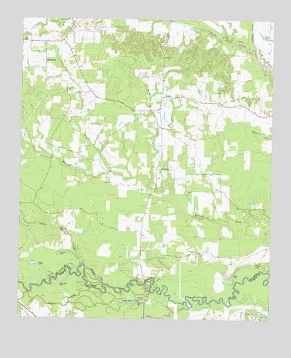
Cuthand, TX USGS Topographic Map
Click on map above to begin viewing in our Map Viewer.

This topographic map contains these locations and features:
Feature Name Type Latitude Longitude GNIS ID View Map
Barnard Draw LakeReservoirN33.4926°W95.0753°1860338View Map
Barnard Lake DamDamN33.4951°W95.0752°1860337View Map
Blackmon Farms Reservoir Number 3ReservoirN33.3754°W95.0257°1865515View Map
Blackmon Farms Reservoir Number 3 DamDamN33.3768°W95.0269°1865514View Map
Brushy LakeLakeN33.3978°W95.0086°1353081View Map
Cheetwood LakeLakeN33.3921°W95.0863°1354337View Map
Cottonwood SloughGutN33.3779°W95.0463°1355130View Map
CuthandPopulated PlaceN33.4676°W95.0555°1379624View Map
Elbow LakeLakeN33.3932°W95.0191°1356885View Map
Farmers LakeLakeN33.4026°W95.1055°1357249View Map
Horseshoe LakeLakeN33.3901°W95.1036°1359660View Map
Langford CreekStreamN33.4851°W95.0088°1372173View Map
Little Mustang CreekStreamN33.3973°W95.0941°1361417View Map
McKinzie ChurchChurchN33.4371°W95.0552°1362502View Map
Pickett CreekStreamN33.4882°W95.0122°1365161View Map
Pine BranchStreamN33.4362°W95.0805°1365269View Map
Pine BranchPopulated PlaceN33.4815°W95.1133°1380357View Map
Ringo CreekStreamN33.4296°W95.0583°1366493View Map
Sanders SloughGutN33.3807°W95.1013°1367674View Map
Stout LakeLakeN33.3972°W95.1181°1369254View Map
Timber LakeLakeN33.3818°W95.0711°1369946View Map
Turner LakeLakeN33.4929°W95.0038°1370292View Map

Note: Coordinates in the location and feature list above are referenced to NAD83 datum.


Copyright (C) 2008-2025 Ryan Niemi / Sunset Dynamics ... All Rights Reserved