TopoQuest Logo
Do you find TopoQuest useful?
Help keep TopoQuest running and adding new maps/features by donating!
Bitcoin:  19c7KJd3qBynnjoSw5npx9KScwjBe4ifkT
Litecoin:  LXs6TkuXGGXo1vDsWCkWVdjQX94eUKd6ui
Home View Maps Find Maps Find Places Resources & Links


Dalton South, Georgia Topographic Map

USGS Map Title: Dalton South, GA
USGS Map MRC: 34084F8
DRG (GeoTIFF) Download: o34084f8.tif


Neighboring USGS Topographic Map Quads:


  Tunnel Hill, GA  
34085G1
 

  Dalton North, GA  
34084G8
 

  Chatsworth, GA  
34084G7
 

  Villanow, GA  
34085F1
 

  Dalton South, GA  
34084F8
 

  Calhoun NE, GA  
34084F7
 

  Sugar Valley, GA  
34085E1
 

  Calhoun North, GA  
34084E8
 

  Redbud, GA  
34084E7


Map MRC Location:

N35°
W85°
N35°
W84°
H8 H7 H6 H5 H4 H3 H2 H1
G8 G7 G6 G5 G4 G3 G2 G1
F8 F7 F6 F5 F4 F3 F2 F1
E8 E7 E6 E5 E4 E3 E2 E1
D8 D7 D6 D5 D4 D3 D2 D1
C8 C7 C6 C5 C4 C3 C2 C1
B8 B7 B6 B5 B4 B3 B2 B1
A8 A7 A6 A5 A4 A3 A2 A1
N34°
W85°
N34°
W84°

Dalton South, GA USGS 1:24K Topographic Map Preview:
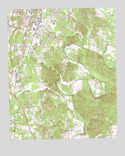
Dalton South, GA USGS Topographic Map
Click on map above to begin viewing in our Map Viewer.

This topographic map contains these locations and features:
Feature Name Type Latitude Longitude GNIS ID View Map
Antioch Baptist ChurchChurchN34.7473°W84.9447°353358View Map
Antioch Elementary SchoolSchoolN34.7406°W84.9343°326961View Map
Beulah Land ChurchChurchN34.6293°W84.9669°353364View Map
Big Jack CreekStreamN34.6762°W84.9277°327114View Map
Camp Lewallen CemeteryCemeteryN34.7084°W84.9711°327339View Map
Camp MaynardLocaleN34.7031°W84.9677°327340View Map
CarbondalePopulated PlaceN34.6445°W84.9938°354990View Map
Center Point ChurchChurchN34.6884°W84.9874°355084View Map
Cove ChurchChurchN34.6401°W84.9936°327533View Map
Crown Mill Historic DistrictParkN34.7459°W84.9708°353387View Map
Crown Mill LakeReservoirN34.6885°W84.9797°337017View Map
Crown Mill Lake DamDamN34.6867°W84.9783°337016View Map
Crown Mill VillagePopulated PlaceN34.7459°W84.9708°353388View Map
Dalton Fire Department Station 4BuildingN34.7430°W84.9987°2604757View Map
Drowning Bear CreekStreamN34.7134°W84.9155°355552View Map
Dug Gap ChurchChurchN34.7340°W84.9974°355565View Map
Eastbrook Middle SchoolSchoolN34.7459°W84.9283°327730View Map
Fairview ChurchChurchN34.7423°W84.9374°327781View Map
First United Pentecostal SchoolSchoolN34.7419°W84.9749°2545590View Map
Five SpringsPopulated PlaceN34.7129°W84.9744°331723View Map
Five Springs ChurchChurchN34.7165°W84.9774°353418View Map
Henton CemeteryCemeteryN34.6829°W84.9030°353439View Map
Holly CreekStreamN34.7045°W84.8908°356316View Map
Holy Hills ChurchChurchN34.6337°W84.9611°328202View Map
Hopewell CemeteryCemeteryN34.7481°W84.9110°328210View Map
Howell CreekStreamN34.6315°W84.9133°328243View Map
Jobs CreekStreamN34.6801°W84.9419°328327View Map
Keiths MillPopulated PlaceN34.7431°W84.8811°332134View Map
Little CreekStreamN34.7137°W84.9147°328537View Map
Little Swamp CreekStreamN34.6792°W84.9777°328581View Map
Loopers BendBendN34.7067°W84.9177°328643View Map
Loopers BridgeBridgeN34.7142°W84.9299°328644View Map
McFarland Hill ChurchChurchN34.7265°W84.9672°328741View Map
Mineral Springs ChurchChurchN34.7312°W84.8863°328817View Map
Olivia ChurchChurchN34.7417°W84.9777°329098View Map
PhelpsPopulated PlaceN34.6981°W84.9833°332651View Map
Pine Grove ChurchChurchN34.7326°W84.8919°329216View Map
PratersvillePopulated PlaceN34.6273°W84.9552°329322View Map
Rays ChapelChurchN34.6431°W84.9544°329376View Map
River Bend ChurchChurchN34.6873°W84.9124°329443View Map
River Bend ChurchChurchN34.6820°W84.9272°321624View Map
Sloan BridgeBridgeN34.6290°W84.9172°329730View Map
Southeast Whitfield County High SchoolSchoolN34.7338°W84.9395°353490View Map
Stacy BranchStreamN34.7287°W84.9483°329804View Map
Swamp CreekStreamN34.6684°W84.9380°329907View Map
Swamp Creek ChurchChurchN34.6512°W84.9869°329908View Map
Tar CreekStreamN34.7390°W84.9538°329931View Map
Temple ChurchChurchN34.7329°W84.9772°329954View Map
Thomason CreekStreamN34.6517°W84.9247°353493View Map
Threadmill LakeReservoirN34.7499°W84.9752°336619View Map
TiltonPopulated PlaceN34.6651°W84.9394°333234View Map
Tilton Baptist ChurchChurchN34.6640°W84.9399°353494View Map
Tilton BridgeBridgeN34.6670°W84.9280°329994View Map
Tilton CemeteryCemeteryN34.6534°W84.9322°329995View Map
Tilton Methodist ChurchChurchN34.6626°W84.9352°353495View Map
Union Grove School (historical)SchoolN34.6270°W84.8866°334572View Map
Valley Point Elementary SchoolSchoolN34.6808°W84.9869°330123View Map
Valley Point Middle SchoolSchoolN34.6810°W84.9892°353505View Map
Whitfield ChurchChurchN34.7292°W84.9986°353512View Map
Whitfield County Fire Department Station 4BuildingN34.7104°W84.9815°2604711View Map
Whitfield County Fire Department Station 5BuildingN34.6536°W84.9773°2604712View Map
Whitfield County Fire Department Station 8BuildingN34.7486°W84.9207°2604003View Map

Note: Coordinates in the location and feature list above are referenced to NAD83 datum.


Copyright (C) 2008-2024 Ryan Niemi / Sunset Dynamics ... All Rights Reserved