TopoQuest Logo
Do you find TopoQuest useful?
Help keep TopoQuest running and adding new maps/features by donating!
Bitcoin:  19c7KJd3qBynnjoSw5npx9KScwjBe4ifkT
Litecoin:  LXs6TkuXGGXo1vDsWCkWVdjQX94eUKd6ui
Home View Maps Find Maps Find Places Resources & Links


Danbury, New Hampshire Topographic Map

USGS Map Title: Danbury, NH
USGS Map MRC: 43071E7
DRG (GeoTIFF) Download: o43071e7.tif


Neighboring USGS Topographic Map Quads:


  Mount Cardigan, NH  
43071F8
 

  Newfound Lake, NH  
43071F7
 

  Ashland, NH  
43071F6
 

  Grafton, NH  
43071E8
 

  Danbury, NH  
43071E7
 

  Bristol, NH  
43071E6
 

  New London, NH  
43071D8
 

  Andover, NH  
43071D7
 

  Franklin, NH  
43071D6


Map MRC Location:

N44°
W72°
N44°
W71°
H8 H7 H6 H5 H4 H3 H2 H1
G8 G7 G6 G5 G4 G3 G2 G1
F8 F7 F6 F5 F4 F3 F2 F1
E8 E7 E6 E5 E4 E3 E2 E1
D8 D7 D6 D5 D4 D3 D2 D1
C8 C7 C6 C5 C4 C3 C2 C1
B8 B7 B6 B5 B4 B3 B2 B1
A8 A7 A6 A5 A4 A3 A2 A1
N43°
W72°
N43°
W71°

Danbury, NH USGS 1:24K Topographic Map Preview:
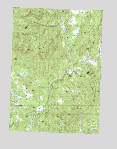
Danbury, NH USGS Topographic Map
Click on map above to begin viewing in our Map Viewer.

This topographic map contains these locations and features:
Feature Name Type Latitude Longitude GNIS ID View Map
Alexander HillSummitN43.6201°W71.8167°865215View Map
AlexandriaPopulated PlaceN43.6115°W71.7929°1989087View Map
Alexandria Mica MineMineN43.6073°W71.8356°865216View Map
Alexandria Police DeptBuildingN43.6122°W71.7947°2752942View Map
Alexandria Village SchoolSchoolN43.6148°W71.7967°870623View Map
Alexandria Volunteer Fire DepartmentBuildingN43.6143°W71.7980°2605037View Map
Benton PondReservoirN43.5201°W71.8379°1775741View Map
Benton Pond Hydro DamDamN43.5201°W71.8379°1775740View Map
Bog PondReservoirN43.5104°W71.8441°865704View Map
Bog Pond DamDamN43.5179°W71.8404°1775475View Map
Bohannan HillSummitN43.5501°W71.8487°865707View Map
Braley HillSummitN43.6004°W71.8626°865762View Map
Burns Hill CemeteryCemeteryN43.6013°W71.7700°865871View Map
Burnt HillSummitN43.5340°W71.7595°865876View Map
Cardigan CampLocaleN43.5306°W71.8301°1916982View Map
Cardigan Mountain OrchardLocaleN43.6244°W71.8103°2611137View Map
Center SchoolSchoolN43.5295°W71.8704°866086View Map
Crawford CemeteryCemeteryN43.6170°W71.7924°866393View Map
DanburyPopulated PlaceN43.5256°W71.8617°866468View Map
Danbury Bog Wildlife Management AreaParkN43.5112°W71.8431°1917019View Map
Danbury Christian ChurchChurchN43.5262°W71.8740°1917020View Map
Danbury Elementary SchoolSchoolN43.5245°W71.8530°1917021View Map
Danbury Police DeptBuildingN43.5282°W71.8681°2752982View Map
Danbury Post OfficePost OfficeN43.5252°W71.8592°1917022View Map
Danbury Volunteer Fire DepartmentBuildingN43.5263°W71.8620°2605193View Map
Dickinson BrookStreamN43.5529°W71.8040°866581View Map
Dickinson HillSummitN43.5192°W71.7884°866582View Map
ElmwoodPopulated PlaceN43.5179°W71.8412°866787View Map
Elmwood SchoolSchoolN43.5170°W71.8412°866790View Map
Forbes MountainSummitN43.5823°W71.8326°866916View Map
Foster PondLakeN43.5885°W71.7912°866941View Map
Fowler RiverStreamN43.6242°W71.7748°866951View Map
Gordon HillSummitN43.5892°W71.7754°867128View Map
Hemp HillSummitN43.6092°W71.7642°867456View Map
Hutchins HillSummitN43.6215°W71.8531°867705View Map
Little Gordon HillSummitN43.5940°W71.7604°868059View Map
Littlefield HillSummitN43.5251°W71.8451°868101View Map
Merrill HillSummitN43.5579°W71.7740°868399View Map
Murray HillPopulated PlaceN43.5423°W71.7954°868667View Map
Murray Hill Summer Home DistrictParkN43.5429°W71.7965°1917189View Map
Newfound Valley AirportAirportN43.5911°W71.7517°873376View Map
Page HillSummitN43.5259°W71.7823°868977View Map
Pattee HillSummitN43.5848°W71.7656°869018View Map
Patten BrookStreamN43.6073°W71.7817°869022View Map
Pillsbury HillSummitN43.5787°W71.8048°869152View Map
Pillsbury MountainSummitN43.5726°W71.8717°869153View Map
Pine HillSummitN43.5865°W71.8306°869181View Map
Pine Hill BrookStreamN43.5587°W71.7937°869185View Map
Plumer HillSummitN43.6017°W71.7698°869267View Map
Poverty PondLakeN43.5086°W71.8013°869332View Map
Riverside CemeteryCemeteryN43.5290°W71.8617°869515View Map
Rowell HillSummitN43.5620°W71.7629°869628View Map
Saint Pauls School CampLocaleN43.5354°W71.8701°869728View Map
School PondLakeN43.5370°W71.8682°869813View Map
Searles HillSummitN43.5115°W71.8301°869833View Map
Simmons LedgesBenchN43.6226°W71.8056°869932View Map
South AlexandriaPopulated PlaceN43.5576°W71.7948°871231View Map
Spear HillSummitN43.5151°W71.8529°870076View Map
Taylor BrookStreamN43.5440°W71.8204°870337View Map
Taylor HillSummitN43.5420°W71.8401°870340View Map
The PinnaclePillarN43.5829°W71.8534°870393View Map
Tinkham HillSummitN43.5898°W71.8587°870446View Map
Tioga BrookStreamN43.5342°W71.8209°870448View Map
Tioga HillSummitN43.5165°W71.8048°870449View Map
Town of AlexandriaCivilN43.6228°W71.8320°873527View Map
Town of DanburyCivilN43.5274°W71.8663°873574View Map
Town of HillCivilN43.5248°W71.7652°873624View Map
Wade State ForestForestN43.5501°W71.7620°1917359View Map
Wild Meadow BrookStreamN43.5351°W71.8473°870889View Map
Willow SchoolSchoolN43.5756°W71.7681°870918View Map

Note: Coordinates in the location and feature list above are referenced to NAD83 datum.


Copyright (C) 2008-2024 Ryan Niemi / Sunset Dynamics ... All Rights Reserved