TopoQuest Logo
Do you find TopoQuest useful?
Help keep TopoQuest running and adding new maps/features by donating!
Bitcoin:  19c7KJd3qBynnjoSw5npx9KScwjBe4ifkT
Litecoin:  LXs6TkuXGGXo1vDsWCkWVdjQX94eUKd6ui
Home View Maps Find Maps Find Places Resources & Links


Grafton, New Hampshire Topographic Map

USGS Map Title: Grafton, NH
USGS Map MRC: 43071E8
DRG (GeoTIFF) Download: o43071e8.tif


Neighboring USGS Topographic Map Quads:


  Mount Cardigan, NH  
43071F8
 

  Newfound Lake, NH  
43071F7
 

  Enfield Center, NH  
43072E1
 

  Grafton, NH  
43071E8
 

  Danbury, NH  
43071E7
 

  Sunapee Lake North, NH  
43072D1
 

  New London, NH  
43071D8
 

  Andover, NH  
43071D7


Map MRC Location:

N44°
W72°
N44°
W71°
H8 H7 H6 H5 H4 H3 H2 H1
G8 G7 G6 G5 G4 G3 G2 G1
F8 F7 F6 F5 F4 F3 F2 F1
E8 E7 E6 E5 E4 E3 E2 E1
D8 D7 D6 D5 D4 D3 D2 D1
C8 C7 C6 C5 C4 C3 C2 C1
B8 B7 B6 B5 B4 B3 B2 B1
A8 A7 A6 A5 A4 A3 A2 A1
N43°
W72°
N43°
W71°

Grafton, NH USGS 1:24K Topographic Map Preview:
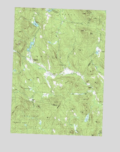
Grafton, NH USGS Topographic Map
Click on map above to begin viewing in our Map Viewer.

This topographic map contains these locations and features:
Feature Name Type Latitude Longitude GNIS ID View Map
Barber MountainSummitN43.6042°W71.9037°865374View Map
Brown BrookStreamN43.6134°W71.9345°865813View Map
Brown MountainSummitN43.6173°W71.8867°865820View Map
Cardigan StationLocaleN43.5712°W71.9718°865997View Map
Crane MountainSummitN43.6220°W71.9023°866386View Map
Currier HillSummitN43.5373°W71.8970°866443View Map
East GraftonPopulated PlaceN43.5687°W71.9276°866706View Map
Fogg HillSummitN43.5176°W71.9484°866909View Map
Ford HillSummitN43.5045°W71.9159°866919View Map
Fords CrossingPopulated PlaceN43.5479°W71.8904°871177View Map
Fords MillPopulated PlaceN43.5415°W71.8998°871178View Map
Garnet MineMineN43.5062°W71.9312°867024View Map
Golden Valley RanchLocaleN43.5865°W71.8820°867108View Map
GraftonPopulated PlaceN43.5587°W71.9440°867164View Map
Grafton Ambulance AssociationBuildingN43.5621°W71.9500°2658901View Map
Grafton CenterPopulated PlaceN43.5740°W71.9734°867165View Map
Grafton Police DeptBuildingN43.5620°W71.9496°2752837View Map
Grafton Post OfficePost OfficeN43.5622°W71.9506°1916570View Map
Grafton Volunteer Fire DepartmentBuildingN43.5621°W71.9502°2605151View Map
Grants PondReservoirN43.5830°W71.8852°867182View Map
Grants Pond DamDamN43.5834°W71.8879°1774822View Map
Halfmoon Pond BrookStreamN43.5756°W71.9829°867318View Map
Hoyt BrookStreamN43.5442°W71.8887°867641View Map
Hoyt BrookStreamN43.5654°W71.9259°867642View Map
Hoyt Brook DamDamN43.5417°W71.8979°1775746View Map
Hoyt Brook PondReservoirN43.5417°W71.8979°1775747View Map
Isinglass MountainSummitN43.6012°W71.9940°867728View Map
Kilton PondReservoirN43.5872°W71.9760°867865View Map
Kilton Pond DamDamN43.5817°W71.9779°1774796View Map
Leeds HillSummitN43.5140°W71.8798°867986View Map
Manfeltree BrookStreamN43.5765°W71.9768°868244View Map
Melvin MountainSummitN43.6020°W71.8959°868374View Map
Mill BrookStreamN43.5612°W71.9237°868441View Map
Moulton HillSummitN43.5015°W71.8904°868577View Map
Mount PleasantRidgeN43.5481°W71.9304°868601View Map
Mud PondLakeN43.5659°W71.9624°868643View Map
Orange PondLakeN43.6229°W71.9529°868921View Map
Pillsbury RidgeRidgeN43.5245°W71.9923°869154View Map
Pine HillSummitN43.5531°W71.8837°869180View Map
Pond LedgesBenchN43.5145°W71.8920°869295View Map
Prescott HillSummitN43.5434°W71.9954°869354View Map
Prescott Hill CemeteryCemeteryN43.5362°W71.9751°869356View Map
Robinson CornerPopulated PlaceN43.5342°W71.9726°871222View Map
Roby HillSummitN43.5651°W71.8901°869552View Map
Rollins HillSummitN43.5262°W71.9623°869591View Map
Sanders BrookStreamN43.5370°W71.9695°869774View Map
Severance HillSummitN43.5240°W71.8992°869852View Map
Shepard HillSummitN43.5865°W71.9065°869898View Map
Smith BrookStreamN43.5601°W71.9509°869963View Map
Smith MountainSummitN43.5301°W71.9390°869978View Map
Stewart HillSummitN43.5262°W71.9181°870174View Map
Tewksbury PondLakeN43.6090°W71.9704°870363View Map
Three Thousand Acre PondLakeN43.5444°W71.9732°870427View Map
Town of GraftonCivilN43.5760°W71.9723°873609View Map
Unification ChurchChurchN43.5698°W71.9287°1916869View Map
Waukeena LakeLakeN43.5174°W71.8960°870687View Map
Whitney PondLakeN43.5536°W71.9742°870869View Map
Williams HillSummitN43.5565°W71.9754°870911View Map

Note: Coordinates in the location and feature list above are referenced to NAD83 datum.


Copyright (C) 2008-2024 Ryan Niemi / Sunset Dynamics ... All Rights Reserved