TopoQuest Logo
Do you find TopoQuest useful?
Help keep TopoQuest running and adding new maps/features by donating!
Bitcoin:  19c7KJd3qBynnjoSw5npx9KScwjBe4ifkT
Litecoin:  LXs6TkuXGGXo1vDsWCkWVdjQX94eUKd6ui
Home View Maps Find Maps Find Places Resources & Links


Danforth, Maine Topographic Map

USGS Map Title: Danforth, ME
USGS Map MRC: 45067F7
DRG (GeoTIFF) Download: o45067f7.tif


Neighboring USGS Topographic Map Quads:


  Haynesville, ME  
45067G8
 

  Orient, ME  
45067G7


  Jimmey Mountain, ME  
45067F8
 

  Danforth, ME  
45067F7
 

  Forest City, ME  
45067F6
 

  Stetson Mountain, ME  
45067E8
 

  Brookton, ME  
45067E7
 

  Forest, ME  
45067E6


Map MRC Location:

N46°
W68°
N46°
W67°
H8 H7 H6 H5 H4 H3 H2 H1
G8 G7 G6 G5 G4 G3 G2 G1
F8 F7 F6 F5 F4 F3 F2 F1
E8 E7 E6 E5 E4 E3 E2 E1
D8 D7 D6 D5 D4 D3 D2 D1
C8 C7 C6 C5 C4 C3 C2 C1
B8 B7 B6 B5 B4 B3 B2 B1
A8 A7 A6 A5 A4 A3 A2 A1
N45°
W68°
N45°
W67°

Danforth, ME USGS 1:24K Topographic Map Preview:
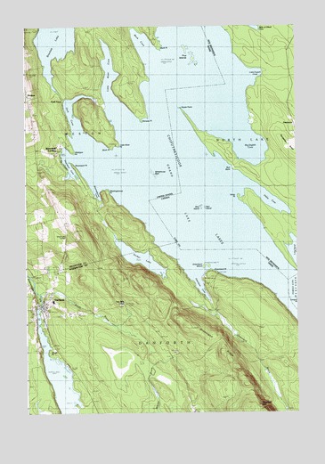
Danforth, ME USGS Topographic Map
Click on map above to begin viewing in our Map Viewer.

This topographic map contains these locations and features:
Feature Name Type Latitude Longitude GNIS ID View Map
Birch PointCapeN45.6440°W67.8661°562344View Map
Birch PointCapeN45.7106°W67.8361°562345View Map
Brackett CemeteryCemeteryN45.7217°W67.8718°2678671View Map
Brackett LakeLakeN45.7462°W67.8607°562838View Map
Butterfield CemeteryCemeteryN45.7093°W67.8609°1910270View Map
Butterfield LandingPopulated PlaceN45.7106°W67.8595°579169View Map
Crooked Brook DamDamN45.6591°W67.8689°1773839View Map
Crooked Brook FlowageReservoirN45.6591°W67.8689°1773840View Map
DanforthPopulated PlaceN45.6603°W67.8683°564764View Map
Danforth Baptist ChurchChurchN45.6603°W67.8700°1909131View Map
Danforth Post OfficePost OfficeN45.6600°W67.8674°1909132View Map
Danforth Public LibraryBuildingN45.6585°W67.8666°2738410View Map
Danforth Volunteer Fire DepartmentBuildingN45.6573°W67.8669°2553100View Map
Dark CoveBayN45.7206°W67.8533°564776View Map
Dark CoveLocaleN45.7256°W67.8606°579003View Map
Davenport CoveBayN45.7037°W67.8553°564784View Map
Davenport PointCapeN45.7051°W67.8539°564785View Map
East Grand SchoolSchoolN45.6613°W67.8626°1909148View Map
Five IslandsIslandN45.7406°W67.7972°566259View Map
Grand LakeLakeN45.7166°W67.7931°581364View Map
Grand Lake GrangeLocaleN45.6820°W67.8578°567032View Map
Greenland BrookStreamN45.6603°W67.7897°567274View Map
Greenland CoveBayN45.6673°W67.7953°567278View Map
Greenland IslandIslandN45.6728°W67.7917°567279View Map
Greenland PointCapeN45.6703°W67.7878°567282View Map
Greenland RidgeRidgeN45.6465°W67.7850°567283View Map
Hilltop CemeteryCemeteryN45.6613°W67.8715°564766View Map
Little River CoveBayN45.7345°W67.8367°570018View Map
Little River PointCapeN45.7123°W67.8325°570026View Map
Mattigan PointCapeN45.7090°W67.8533°570919View Map
Meetinghouse CoveBayN45.6970°W67.8445°571121View Map
Meetinghouse PointCapeN45.6976°W67.8383°571124View Map
Northern Washington Southern Aroostook Regional AmbulanceBuildingN45.6688°W67.8706°2666813View Map
Norway PointCapeN45.7206°W67.8222°572517View Map
Sandy BrookStreamN45.6640°W67.8706°574873View Map
Sucker LakeLakeN45.6749°W67.8221°576490View Map
Town of DanforthCivilN45.6271°W67.8381°582433View Map
Town of WestonCivilN45.7286°W67.8641°582808View Map
Two Mile CurveLocaleN45.6601°W67.8308°577506View Map
Union HallBuildingN45.6595°W67.8678°1909375View Map
Whitehorse ReefBarN45.7023°W67.8164°578385View Map
Work CoveBayN45.7451°W67.8200°578701View Map
Work PointCapeN45.7423°W67.8131°578702View Map

Note: Coordinates in the location and feature list above are referenced to NAD83 datum.


Copyright (C) 2008-2025 Ryan Niemi / Sunset Dynamics ... All Rights Reserved