TopoQuest Logo
Do you find TopoQuest useful?
Help keep TopoQuest running and adding new maps/features by donating!
Bitcoin:  19c7KJd3qBynnjoSw5npx9KScwjBe4ifkT
Litecoin:  LXs6TkuXGGXo1vDsWCkWVdjQX94eUKd6ui
Home View Maps Find Maps Find Places Resources & Links


Dark Cove Mountain, Maine Topographic Map

USGS Map Title: Dark Cove Mountain, ME
USGS Map MRC: 45067B8
DRG (GeoTIFF) Download: o45067b8.tif


Neighboring USGS Topographic Map Quads:


  Bottle Lake, ME  
45068C1
 

  Scraggly Lake, ME  
45067C8
 

  Oxbrook Lakes, ME  
45067C7
 

  Duck Lake, ME  
45068B1
 

  Dark Cove Mountain, ME  
45067B8
 

  Grand Lake Stream, ME  
45067B7
 

  Gassabias Lake, ME  
45068A1
 

  Fletcher Peak, ME  
45067A8
 

  Monroe Lake, ME  
45067A7


Map MRC Location:

N46°
W68°
N46°
W67°
H8 H7 H6 H5 H4 H3 H2 H1
G8 G7 G6 G5 G4 G3 G2 G1
F8 F7 F6 F5 F4 F3 F2 F1
E8 E7 E6 E5 E4 E3 E2 E1
D8 D7 D6 D5 D4 D3 D2 D1
C8 C7 C6 C5 C4 C3 C2 C1
B8 B7 B6 B5 B4 B3 B2 B1
A8 A7 A6 A5 A4 A3 A2 A1
N45°
W68°
N45°
W67°

Dark Cove Mountain, ME USGS 1:24K Topographic Map Preview:
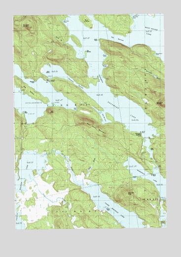
Dark Cove Mountain, ME USGS Topographic Map
Click on map above to begin viewing in our Map Viewer.

This topographic map contains these locations and features:
Feature Name Type Latitude Longitude GNIS ID View Map
Bear IslandIslandN45.2478°W67.9411°561843View Map
Belmont PointCapeN45.2123°W67.9831°562030View Map
Big IslandIslandN45.2078°W67.9903°562194View Map
Big Sand BeachBeachN45.1878°W67.9900°562232View Map
Blood BrookStreamN45.2345°W67.9564°562581View Map
Buck KnollSummitN45.1938°W67.9701°563108View Map
Burnt PointCapeN45.1565°W67.8889°563264View Map
Coffin PointCapeN45.2359°W67.9311°564160View Map
Dark CoveBayN45.1962°W67.9511°564773View Map
Dark Cove MountainSummitN45.1876°W67.9424°564777View Map
Dead StreamStreamN45.1548°W67.9858°564893View Map
Deer BrookStreamN45.1953°W67.9342°564972View Map
Deer Brook CoveBayN45.1903°W67.9278°564975View Map
Dennison PortageLocaleN45.2131°W67.9708°565045View Map
Dobsis DamDamN45.2117°W67.9699°1774599View Map
Elsemore LandingPopulated PlaceN45.1812°W67.8981°579292View Map
Flood CoveBayN45.2265°W67.9250°566317View Map
Fourth Lake StreamStreamN45.1481°W67.9428°566486View Map
Fourth Machias LakeLakeN45.1280°W67.9983°566487View Map
Getchel LakesLakeN45.1319°W67.8780°566765View Map
Hayes BrookStreamN45.1523°W67.9458°567819View Map
Jumbo LandingPopulated PlaceN45.2145°W67.8758°579443View Map
McLellan CoveBayN45.2481°W67.8986°571022View Map
Morrison CoveBayN45.2465°W67.9595°571680View Map
Otter PointCapeN45.1712°W67.8919°572832View Map
Pocumcus LakeLakeN45.1942°W67.9131°573549View Map
Pocumcus NarrowsChannelN45.2101°W67.9495°573550View Map
Porcupine MountainSummitN45.2432°W67.9870°573665View Map
Rock IslandIslandN45.2181°W67.9700°574343View Map
Rocky CoveBayN45.1548°W67.9031°574385View Map
Saint Cyr PointCapeN45.1820°W67.8961°578862View Map
Sakom TownshipCivilN45.2112°W67.9797°1987557View Map
Spring CoveBayN45.2203°W67.9264°576102View Map
Steamboat CoveBayN45.2265°W67.8864°576288View Map
Sysladobsis LakeReservoirN45.2116°W67.9699°576630View Map
The BirchesLocaleN45.2292°W67.9411°576756View Map
The NarrowsChannelN45.2373°W67.9186°576860View Map
The PinesPopulated PlaceN45.1942°W67.9922°579764View Map
Third Lake RidgeRidgeN45.1451°W67.9100°576961View Map
Trafton RockIslandN45.1365°W67.9228°577271View Map
Unknown StreamStreamN45.1517°W67.9997°577570View Map
Wabassus LakeLakeN45.1526°W67.8829°577749View Map

Note: Coordinates in the location and feature list above are referenced to NAD83 datum.


Copyright (C) 2008-2024 Ryan Niemi / Sunset Dynamics ... All Rights Reserved