TopoQuest Logo
Do you find TopoQuest useful?
Help keep TopoQuest running and adding new maps/features by donating!
Bitcoin:  19c7KJd3qBynnjoSw5npx9KScwjBe4ifkT
Litecoin:  LXs6TkuXGGXo1vDsWCkWVdjQX94eUKd6ui
Home View Maps Find Maps Find Places Resources & Links


Grand Lake Stream, Maine Topographic Map

USGS Map Title: Grand Lake Stream, ME
USGS Map MRC: 45067B7
DRG (GeoTIFF) Download: o45067b7.tif


Neighboring USGS Topographic Map Quads:


  Scraggly Lake, ME  
45067C8
 

  Oxbrook Lakes, ME  
45067C7
 

  Waite, ME  
45067C6
 

  Dark Cove Mountain, ME  
45067B8
 

  Grand Lake Stream, ME  
45067B7
 

  Big Lake, ME  
45067B6
 

  Fletcher Peak, ME  
45067A8
 

  Monroe Lake, ME  
45067A7
 

  Clifford Lake, ME  
45067A6


Map MRC Location:

N46°
W68°
N46°
W67°
H8 H7 H6 H5 H4 H3 H2 H1
G8 G7 G6 G5 G4 G3 G2 G1
F8 F7 F6 F5 F4 F3 F2 F1
E8 E7 E6 E5 E4 E3 E2 E1
D8 D7 D6 D5 D4 D3 D2 D1
C8 C7 C6 C5 C4 C3 C2 C1
B8 B7 B6 B5 B4 B3 B2 B1
A8 A7 A6 A5 A4 A3 A2 A1
N45°
W68°
N45°
W67°

Grand Lake Stream, ME USGS 1:24K Topographic Map Preview:
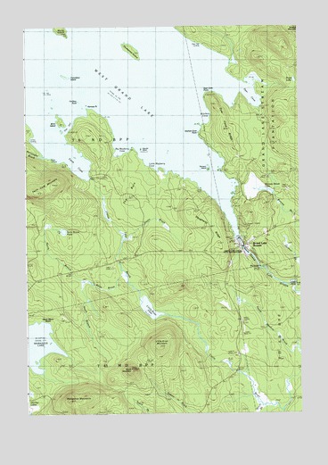
Grand Lake Stream, ME USGS Topographic Map
Click on map above to begin viewing in our Map Viewer.

This topographic map contains these locations and features:
Feature Name Type Latitude Longitude GNIS ID View Map
Bear Trap LandingPopulated PlaceN45.2437°W67.7928°579127View Map
Big FallsFallsN45.1737°W67.7692°562164View Map
Big Mayberry CoveBayN45.2115°W67.8344°562207View Map
Birch IslandIslandN45.2203°W67.8617°562306View Map
Bonney Brook LakeLakeN45.1972°W67.7657°562730View Map
Burroughs BrookStreamN45.2092°W67.8692°563281View Map
Caribou RockIslandN45.2259°W67.8528°563541View Map
Columbus IslandIslandN45.2345°W67.8586°564253View Map
Daugherty RidgeRidgeN45.1876°W67.7956°564783View Map
Dawn Marie BeachBeachN45.1553°W67.8689°564829View Map
Dyer CoveBayN45.2292°W67.7733°565459View Map
Dyer Cove PointCapeN45.2290°W67.7922°565461View Map
Dyer Cove RidgeRidgeN45.2170°W67.7844°565462View Map
Farm CoveBayN45.2070°W67.8542°566039View Map
Farm Cove DamDamN45.2012°W67.8453°566040View Map
Farm Cove MountainSummitN45.1966°W67.8696°566042View Map
Grand Lake BrookStreamN45.1615°W67.8242°567030View Map
Grand Lake StreamPopulated PlaceN45.1795°W67.7744°567035View Map
Grand Lake Stream DamDamN45.1813°W67.7780°1773927View Map
Grand Lake Stream Post OfficePost OfficeN45.1787°W67.7739°1909184View Map
Grand Lake Stream State Fish HatcheryLocaleN45.1778°W67.7742°1909185View Map
Grand Lake Stream Volunteer AmbulanceBuildingN45.1794°W67.7733°2666806View Map
Grand Lake Stream Volunteer Fire DepartmentBuildingN45.1794°W67.7734°2553144View Map
Hardwood IslandIslandN45.2428°W67.8278°567622View Map
Indian LandingPopulated PlaceN45.2081°W67.8678°579429View Map
Kitchen CoveBayN45.2215°W67.7936°569226View Map
Kitchen Cove PointCapeN45.2162°W67.7967°569227View Map
Kole Kill IslandIslandN45.2109°W67.8236°569277View Map
Little FallsFallsN45.1673°W67.7514°569773View Map
Little Mayberry CoveBayN45.2053°W67.8169°569899View Map
Little River LakeLakeN45.1589°W67.8188°570021View Map
Little River MountainSummitN45.1467°W67.8144°570025View Map
Marks IslandIslandN45.2495°W67.8608°570787View Map
Munson IslandIslandN45.2042°W67.7919°571983View Map
North Branch Rolfe BrookStreamN45.1684°W67.8514°572288View Map
Norway PointCapeN45.2251°W67.8494°572514View Map
Pond LakeLakeN45.2324°W67.7518°573606View Map
Rolfe BrookStreamN45.1701°W67.8311°574432View Map
Rolfe Brook PondLakeN45.1841°W67.8577°574433View Map
Scotts BrookStreamN45.1820°W67.8319°575056View Map
South Branch Rolfe BrookStreamN45.1684°W67.8514°575796View Map
South BrookStreamN45.1253°W67.7706°575822View Map
South MountainSummitN45.1390°W67.8266°575871View Map
T6 ND BPPCivilN45.2278°W67.8580°1987558View Map
The BurnAreaN45.1967°W67.8272°576776View Map
The GutChannelN45.2187°W67.8567°576809View Map
Unorganized Territory of North WashingtonCivilN45.1651°W67.8014°582637View Map
Wabassus MountainSummitN45.1294°W67.8555°577750View Map
West Grand LakeReservoirN45.1813°W67.7780°578151View Map

Note: Coordinates in the location and feature list above are referenced to NAD83 datum.


Copyright (C) 2008-2024 Ryan Niemi / Sunset Dynamics ... All Rights Reserved