TopoQuest Logo
Do you find TopoQuest useful?
Help keep TopoQuest running and adding new maps/features by donating!
Bitcoin:  19c7KJd3qBynnjoSw5npx9KScwjBe4ifkT
Litecoin:  LXs6TkuXGGXo1vDsWCkWVdjQX94eUKd6ui
Home View Maps Find Maps Find Places Resources & Links


Darwin, Minnesota Topographic Map

USGS Map Title: Darwin, MN
USGS Map MRC: 45094A4
DRG (GeoTIFF) Download: o45094a4.tif


Neighboring USGS Topographic Map Quads:


  Litchfield North, MN  
45094B5
 

  Forest City, MN  
45094B4
 

  Kingston, MN  
45094B3
 

  Litchfield South, MN  
45094A5
 

  Darwin, MN  
45094A4
 

  Dassel, MN  
45094A3
 

  Cedar Mills, MN  
44094H5
 

  Hutchinson West, MN  
44094H4
 

  Hutchinson East, MN  
44094H3


Map MRC Location:

N46°
W95°
N46°
W94°
H8 H7 H6 H5 H4 H3 H2 H1
G8 G7 G6 G5 G4 G3 G2 G1
F8 F7 F6 F5 F4 F3 F2 F1
E8 E7 E6 E5 E4 E3 E2 E1
D8 D7 D6 D5 D4 D3 D2 D1
C8 C7 C6 C5 C4 C3 C2 C1
B8 B7 B6 B5 B4 B3 B2 B1
A8 A7 A6 A5 A4 A3 A2 A1
N45°
W95°
N45°
W94°

Darwin, MN USGS 1:24K Topographic Map Preview:
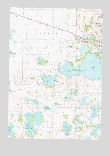
Darwin, MN USGS Topographic Map
Click on map above to begin viewing in our Map Viewer.

This topographic map contains these locations and features:
Feature Name Type Latitude Longitude GNIS ID View Map
All Saints Lutheran ChurchChurchN45.0956°W94.4094°2066050View Map
Belle Lake SchoolSchoolN45.0002°W94.4005°639890View Map
Benton LakeLakeN45.0380°W94.4755°639941View Map
Birch LakeLakeN45.0402°W94.4186°640166View Map
CaseyPopulated PlaceN45.0661°W94.4414°654633View Map
Casey LakeLakeN45.0754°W94.4573°640960View Map
Casey Post Office (historical)Post OfficeN45.0661°W94.4411°2065931View Map
Casey Post Office (historical)Post OfficeN45.0661°W94.4411°2066568View Map
Casey SchoolSchoolN45.0877°W94.4622°640963View Map
Center SchoolSchoolN45.0266°W94.4400°641051View Map
Church of Saint JohnChurchN45.0947°W94.4042°2066688View Map
Church of Saint JohnChurchN45.0947°W94.4042°2066051View Map
City of DarwinCivilN45.0968°W94.4136°2393721View Map
DarwinLocaleN45.0986°W94.4103°2066054View Map
DarwinPopulated PlaceN45.0964°W94.4108°642644View Map
Darwin City and Township HallBuildingN45.0947°W94.4058°2066052View Map
Darwin Post OfficePost OfficeN45.0973°W94.4106°2066053View Map
Darwin Winter Park Rest AreaLocaleN45.0925°W94.3764°2066076View Map
Eighty Acre LakeLakeN45.0338°W94.4333°643215View Map
Ellsworth CemeteryCemeteryN45.0418°W94.4404°1815337View Map
Ellsworth LandingLocaleN45.0577°W94.3792°1815340View Map
Fallon LakeLakeN45.0071°W94.3840°643551View Map
Greenleaf LakeLakeN45.0116°W94.4703°644446View Map
Hurley LakeLakeN45.0347°W94.4639°645307View Map
Jewitt LakeLakeN45.0269°W94.3843°645645View Map
Lake DarwinLakeN45.0869°W94.3990°642645View Map
Lake ErieLakeN45.0108°W94.4205°643403View Map
Lake StellaLakeN45.0668°W94.4194°652614View Map
Lake WashingtonLakeN45.0695°W94.3759°653826View Map
Lakeview OrchardLocaleN45.0214°W94.4058°2647723View Map
Long LakeLakeN45.0178°W94.4045°647040View Map
Maadi FarmLocaleN45.1181°W94.4636°2702960View Map
Manuella County ParkParkN45.0558°W94.4367°1815338View Map
Manuella LakeLakeN45.0570°W94.4452°647458View Map
Minnie-Man State Wildlife Management AreaParkN45.0575°W94.4736°1815339View Map
Mud LakeLakeN45.0300°W94.4478°648227View Map
Porter LakeLakeN45.0337°W94.3995°649678View Map
Porter SchoolSchoolN45.0441°W94.4097°649679View Map
Saint Johns CemeteryCemeteryN45.0936°W94.4041°1815341View Map
Saint Peters ChurchChurchN45.0419°W94.4392°651029View Map
School House LakeLakeN45.0462°W94.4103°651310View Map
Sioux LakeLakeN45.0211°W94.4630°652084View Map
Stevens LakeLakeN45.0794°W94.4097°652627View Map
Township of DarwinCivilN45.1098°W94.4418°663929View Map
Township of EllsworthCivilN45.0226°W94.4402°664077View Map
Turtle LakeLakeN45.0966°W94.3967°653373View Map
Willie LakeLakeN45.0068°W94.4964°654173View Map

Note: Coordinates in the location and feature list above are referenced to NAD83 datum.


Copyright (C) 2008-2024 Ryan Niemi / Sunset Dynamics ... All Rights Reserved