TopoQuest Logo
Do you find TopoQuest useful?
Help keep TopoQuest running and adding new maps/features by donating!
Bitcoin:  19c7KJd3qBynnjoSw5npx9KScwjBe4ifkT
Litecoin:  LXs6TkuXGGXo1vDsWCkWVdjQX94eUKd6ui
Home View Maps Find Maps Find Places Resources & Links


Forest City, Minnesota Topographic Map

USGS Map Title: Forest City, MN
USGS Map MRC: 45094B4
DRG (GeoTIFF) Download: o45094b4.tif


Neighboring USGS Topographic Map Quads:


  Eden Valley, MN  
45094C5
 

  Watkins, MN  
45094C4
 

  Kimball, MN  
45094C3
 

  Litchfield North, MN  
45094B5
 

  Forest City, MN  
45094B4
 

  Kingston, MN  
45094B3
 

  Litchfield South, MN  
45094A5
 

  Darwin, MN  
45094A4
 

  Dassel, MN  
45094A3


Map MRC Location:

N46°
W95°
N46°
W94°
H8 H7 H6 H5 H4 H3 H2 H1
G8 G7 G6 G5 G4 G3 G2 G1
F8 F7 F6 F5 F4 F3 F2 F1
E8 E7 E6 E5 E4 E3 E2 E1
D8 D7 D6 D5 D4 D3 D2 D1
C8 C7 C6 C5 C4 C3 C2 C1
B8 B7 B6 B5 B4 B3 B2 B1
A8 A7 A6 A5 A4 A3 A2 A1
N45°
W95°
N45°
W94°

Forest City, MN USGS 1:24K Topographic Map Preview:
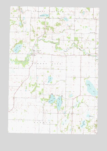
Forest City, MN USGS Topographic Map
Click on map above to begin viewing in our Map Viewer.

This topographic map contains these locations and features:
Feature Name Type Latitude Longitude GNIS ID View Map
County Ditch Number FortytwoCanalN45.2411°W94.4028°1815443View Map
County Ditch Number ThirtysixCanalN45.1514°W94.3758°1815437View Map
Dunns LakeLakeN45.1553°W94.4289°642985View Map
Farley SchoolSchoolN45.1808°W94.4094°643562View Map
Forest CityPopulated PlaceN45.2064°W94.4664°643796View Map
Forest City Post Office (historical)Post OfficeN45.2064°W94.4661°2065925View Map
Forest City Post Office (historical)Post OfficeN45.2064°W94.4661°2066562View Map
Hanon LakeSwampN45.1554°W94.4038°1815438View Map
Happy Corner SchoolSchoolN45.2394°W94.4639°644655View Map
Mar Doll FarmLocaleN45.2081°W94.4594°2702958View Map
Memorial ParkParkN45.2019°W94.4658°1815440View Map
Mud LakeLakeN45.2085°W94.4886°648236View Map
Mud LakeSwampN45.1359°W94.4203°1815450View Map
North Buckley LakeLakeN45.1444°W94.3878°650397View Map
Ostmark ChurchChurchN45.2202°W94.3997°649030View Map
Ostmark Lutheran Church CemeteryCemeteryN45.2202°W94.3998°2066032View Map
Peifer SchoolSchoolN45.1336°W94.4419°649227View Map
Pleasant View SchoolSchoolN45.2277°W94.4092°649585View Map
Powers LakeLakeN45.1700°W94.3841°649698View Map
Rice LakeLakeN45.1785°W94.4424°649988View Map
Richardson LakeLakeN45.1587°W94.4390°650060View Map
Rohrbeck LakeLakeN45.2416°W94.4514°650227View Map
Saint Gertrude CemeteryCemeteryN45.2044°W94.4587°2066033View Map
Saint Gertrude ChurchChurchN45.2052°W94.4594°1815442View Map
Saint Matthews ChurchChurchN45.2016°W94.4669°1815439View Map
Shaw Memorial ParkParkN45.2033°W94.4669°1815441View Map
Silver Leaf FarmsLocaleN45.2117°W94.4981°2702980View Map
South Buckley LakeLakeN45.1355°W94.3935°662873View Map
T and T FarmsLocaleN45.2044°W94.4981°2702991View Map
Taylor SchoolSchoolN45.1700°W94.4622°653054View Map
Township of Forest CityCivilN45.1955°W94.4404°664192View Map
Wagner DairyLocaleN45.1692°W94.4508°2702989View Map
West Kingston CemeteryCemeteryN45.2250°W94.3798°653973View Map

Note: Coordinates in the location and feature list above are referenced to NAD83 datum.


Copyright (C) 2008-2024 Ryan Niemi / Sunset Dynamics ... All Rights Reserved