TopoQuest Logo
Do you find TopoQuest useful?
Help keep TopoQuest running and adding new maps/features by donating!
Bitcoin:  19c7KJd3qBynnjoSw5npx9KScwjBe4ifkT
Litecoin:  LXs6TkuXGGXo1vDsWCkWVdjQX94eUKd6ui
Home View Maps Find Maps Find Places Resources & Links


Davis Point, Colorado Topographic Map

USGS Map Title: Davis Point, CO
USGS Map MRC: 38108D2
DRG (GeoTIFF) Download: o38108d2.tif


Neighboring USGS Topographic Map Quads:


  Cottonwood Basin, CO  
38108E3
 

  Camel Back, CO  
38108E2
 

  Hoovers Corner, CO  
38108E1
 

  Moore Mesa, CO  
38108D3
 

  Davis Point, CO  
38108D2
 

  Dry Creek Basin, CO  
38108D1
 

  Ute, CO  
38108C3
 

  Antone Spring, CO  
38108C2
 

  Pryor Creek, CO  
38108C1


Map MRC Location:

N39°
W109°
N39°
W108°
H8 H7 H6 H5 H4 H3 H2 H1
G8 G7 G6 G5 G4 G3 G2 G1
F8 F7 F6 F5 F4 F3 F2 F1
E8 E7 E6 E5 E4 E3 E2 E1
D8 D7 D6 D5 D4 D3 D2 D1
C8 C7 C6 C5 C4 C3 C2 C1
B8 B7 B6 B5 B4 B3 B2 B1
A8 A7 A6 A5 A4 A3 A2 A1
N38°
W109°
N38°
W108°

Davis Point, CO USGS 1:24K Topographic Map Preview:
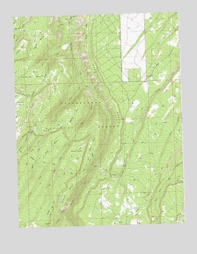
Davis Point, CO USGS Topographic Map
Click on map above to begin viewing in our Map Viewer.

This topographic map contains these locations and features:
Feature Name Type Latitude Longitude GNIS ID View Map
Al Wright CreekStreamN38.4767°W108.2206°185798View Map
Ashley RidgeRidgeN38.4361°W108.2451°203163View Map
Beach CreekStreamN38.4317°W108.2256°185793View Map
Bull CreekStreamN38.4489°W108.1884°185787View Map
Christie CreekStreamN38.4300°W108.2406°185795View Map
Coal Bank TrailTrailN38.4083°W108.1990°185799View Map
Davis BasinBasinN38.4236°W108.1929°185814View Map
Davis PointSummitN38.4167°W108.2104°185808View Map
East BasinBasinN38.4500°W108.2256°185802View Map
East Bull CreekStreamN38.4239°W108.2101°185801View Map
Goddard BenchBenchN38.3915°W108.2156°185809View Map
Goddard CreekStreamN38.3858°W108.2123°185805View Map
Grays CreekStreamN38.3769°W108.1462°185813View Map
Horseshoe BasinBasinN38.4653°W108.2395°203164View Map
Long CreekStreamN38.4600°W108.1976°185794View Map
Moore Basin LakeLakeN38.4930°W108.2497°185803View Map
Murray ParkFlatN38.4417°W108.2062°185806View Map
Oak HillSummitN38.4044°W108.1776°185810View Map
Pine MesaSummitN38.4139°W108.2312°185800View Map
Roubideau BenchBenchN38.4514°W108.1798°203139View Map
Rouvideau TrailTrailN38.4028°W108.2173°203165View Map
Terrible CreekStreamN38.4419°W108.2204°185796View Map
Transfer TrailTrailN38.4278°W108.2001°185807View Map
Traver BasinBasinN38.4855°W108.2312°185804View Map
Traver CreekStreamN38.4825°W108.2062°185797View Map
Traver TrailTrailN38.4828°W108.2370°203141View Map
Uncompahgre PlateauPlainN38.3753°W108.1259°169608View Map

Note: Coordinates in the location and feature list above are referenced to NAD83 datum.


Copyright (C) 2008-2024 Ryan Niemi / Sunset Dynamics ... All Rights Reserved