TopoQuest Logo
Do you find TopoQuest useful?
Help keep TopoQuest running and adding new maps/features by donating!
Bitcoin:  19c7KJd3qBynnjoSw5npx9KScwjBe4ifkT
Litecoin:  LXs6TkuXGGXo1vDsWCkWVdjQX94eUKd6ui
Home View Maps Find Maps Find Places Resources & Links


Dawson, New Mexico Topographic Map

USGS Map Title: Dawson, NM
USGS Map MRC: 36104F7
DRG (GeoTIFF) Download: o36104f7.tif


Neighboring USGS Topographic Map Quads:


  Casa Grande SW, NM  
36104G8
 

  Caliente Canyon South, NM  
36104G7
 

  Curtis Camp, NM  
36104G6
 

  House Canyon, NM  
36104F8
 

  Dawson, NM  
36104F7
 

  Saltpeter Mountain, NM  
36104F6
 

  Cimarron, NM  
36104E8
 

  Cimarron SE, NM  
36104E7
 

  Colfax, NM  
36104E6


Map MRC Location:

N37°
W105°
N37°
W104°
H8 H7 H6 H5 H4 H3 H2 H1
G8 G7 G6 G5 G4 G3 G2 G1
F8 F7 F6 F5 F4 F3 F2 F1
E8 E7 E6 E5 E4 E3 E2 E1
D8 D7 D6 D5 D4 D3 D2 D1
C8 C7 C6 C5 C4 C3 C2 C1
B8 B7 B6 B5 B4 B3 B2 B1
A8 A7 A6 A5 A4 A3 A2 A1
N36°
W105°
N36°
W104°

Dawson, NM USGS 1:24K Topographic Map Preview:
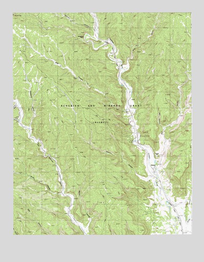
Dawson, NM USGS Topographic Map
Click on map above to begin viewing in our Map Viewer.

This topographic map contains these locations and features:
Feature Name Type Latitude Longitude GNIS ID View Map
Beaubien and Miranda GrantCivilN36.6900°W104.8219°169597View Map
Biglow CanyonValleyN36.6284°W104.8250°886375View Map
Box CanyonValleyN36.6614°W104.7744°886670View Map
Burnt CanyonValleyN36.6473°W104.8414°886947View Map
C S Cattle CompanyLocaleN36.6659°W104.7756°924609View Map
Capitan HillPopulated PlaceN36.6703°W104.7744°899558View Map
Capitan HillSummitN36.6728°W104.7764°924768View Map
Dawson (historical)Populated PlaceN36.6642°W104.7747°902230View Map
Dawson CanyonValleyN36.6570°W104.7775°888228View Map
Dawson Number 1 MineMineN36.6903°W104.7619°939684View Map
Dawson Number 10MineN36.6595°W104.7822°915713View Map
Dawson Number 2 MineMineN36.6903°W104.7619°939726View Map
Dawson Number 3 MineMineN36.6903°W104.7619°939728View Map
Dawson Number 4 MineMineN36.6903°W104.7619°939729View Map
Dawson Number 5MineN36.6794°W104.7868°915664View Map
Dawson Number 6MineN36.6861°W104.7656°915665View Map
Dawson Number 7MineN36.6761°W104.7831°915666View Map
Dawson Number 8 MineMineN36.6600°W104.8006°939686View Map
Dawson Number 9 MineMineN36.6600°W104.8006°939724View Map
Dawson Post Office (historical)Post OfficeN36.6642°W104.7747°938168View Map
Dawson Weather StationLocaleN36.6642°W104.7747°932554View Map
Horseshoe BendBendN36.7359°W104.8239°890189View Map
Lauretta MineMineN36.6864°W104.7872°890982View Map
Loretta (historical)Populated PlaceN36.6801°W104.7897°902064View Map
Rail CanyonValleyN36.6617°W104.7744°893613View Map
Speilman CanyonValleyN36.7398°W104.8172°895221View Map
Spring CanyonValleyN36.6267°W104.7594°895260View Map
Stag CanyonValleyN36.6948°W104.7975°911382View Map
Stamped CanyonValleyN36.6859°W104.8639°895294View Map
Stout CanyonValleyN36.7189°W104.7953°895381View Map
Trail CanyonValleyN36.6889°W104.8711°895789View Map
Valdez CanyonValleyN36.6973°W104.8717°912022View Map

Note: Coordinates in the location and feature list above are referenced to NAD83 datum.


Copyright (C) 2008-2025 Ryan Niemi / Sunset Dynamics ... All Rights Reserved