TopoQuest Logo
Do you find TopoQuest useful?
Help keep TopoQuest running and adding new maps/features by donating!
Bitcoin:  19c7KJd3qBynnjoSw5npx9KScwjBe4ifkT
Litecoin:  LXs6TkuXGGXo1vDsWCkWVdjQX94eUKd6ui
Home View Maps Find Maps Find Places Resources & Links


Colfax, New Mexico Topographic Map

USGS Map Title: Colfax, NM
USGS Map MRC: 36104E6
DRG (GeoTIFF) Download: o36104e6.tif


Neighboring USGS Topographic Map Quads:


  Dawson, NM  
36104F7
 

  Saltpeter Mountain, NM  
36104F6
 

  Koehler, NM  
36104F5
 

  Cimarron SE, NM  
36104E7
 

  Colfax, NM  
36104E6
 

  Maxwell, NM  
36104E5
 

  Miami NE, NM  
36104D7
 

  Springer Lake, NM  
36104D6
 

  French, NM  
36104D5


Map MRC Location:

N37°
W105°
N37°
W104°
H8 H7 H6 H5 H4 H3 H2 H1
G8 G7 G6 G5 G4 G3 G2 G1
F8 F7 F6 F5 F4 F3 F2 F1
E8 E7 E6 E5 E4 E3 E2 E1
D8 D7 D6 D5 D4 D3 D2 D1
C8 C7 C6 C5 C4 C3 C2 C1
B8 B7 B6 B5 B4 B3 B2 B1
A8 A7 A6 A5 A4 A3 A2 A1
N36°
W105°
N36°
W104°

Colfax, NM USGS 1:24K Topographic Map Preview:
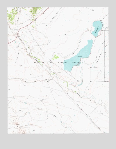
Colfax, NM USGS Topographic Map
Click on map above to begin viewing in our Map Viewer.

This topographic map contains these locations and features:
Feature Name Type Latitude Longitude GNIS ID View Map
Cedar HillsSummitN36.5089°W104.7381°887335View Map
ColfaxPopulated PlaceN36.5967°W104.7383°898535View Map
Colfax CountyCivilN36.6061°W104.6468°929117View Map
Colfax Post Office (historical)Post OfficeN36.5967°W104.7383°937975View Map
Colmor Post Office (historical)Post OfficeN36.5967°W104.7383°938149View Map
High Line DitchCanalN36.5978°W104.6808°889956View Map
Laguna MadreReservoirN36.6068°W104.6367°897985View Map
Lake EightLakeN36.5742°W104.6894°901967View Map
Lake SevenLakeN36.5678°W104.6878°902474View Map
MartinezLocaleN36.5600°W104.6944°927331View Map
MessickLocaleN36.5789°W104.7175°927332View Map
PompoeLocaleN36.5628°W104.7033°927296View Map
Saltpeter CreekStreamN36.5989°W104.7389°894377View Map
South Laguna LateralCanalN36.5825°W104.6369°895076View Map
Stubblefield ArroyoStreamN36.5356°W104.6433°895401View Map
Stubblefield DamDamN36.5667°W104.6672°923892View Map
Stubblefield LateralCanalN36.5595°W104.6342°895404View Map
Stubblefield ReservoirReservoirN36.5743°W104.6628°923893View Map
Stublefield DamDamN36.5745°W104.6600°895406View Map
Van Bremmer CreekStreamN36.5567°W104.6914°912067View Map
Vermejo DitchCanalN36.5848°W104.6622°896123View Map

Note: Coordinates in the location and feature list above are referenced to NAD83 datum.


Copyright (C) 2008-2025 Ryan Niemi / Sunset Dynamics ... All Rights Reserved