TopoQuest Logo
Do you find TopoQuest useful?
Help keep TopoQuest running and adding new maps/features by donating!
Bitcoin:  19c7KJd3qBynnjoSw5npx9KScwjBe4ifkT
Litecoin:  LXs6TkuXGGXo1vDsWCkWVdjQX94eUKd6ui
Home View Maps Find Maps Find Places Resources & Links


Dayton, Nevada Topographic Map

USGS Map Title: Dayton, NV
USGS Map MRC: 39119B5
DRG (GeoTIFF) Download: o39119b5.tif


Neighboring USGS Topographic Map Quads:


  Virginia City, NV  
39119C6
 

  Flowery Peak, NV  
39119C5
 

  Misfits Flat, NV  
39119C4
 

  New Empire, NV  
39119B6
 

  Dayton, NV  
39119B5
 

  Como, NV  
39119B4
 

  McTarnahan Hill, NV  
39119A6
 

  Mineral Peak, NV  
39119A5
 

  Mount Como, NV  
39119A4


Map MRC Location:

N40°
W120°
N40°
W119°
H8 H7 H6 H5 H4 H3 H2 H1
G8 G7 G6 G5 G4 G3 G2 G1
F8 F7 F6 F5 F4 F3 F2 F1
E8 E7 E6 E5 E4 E3 E2 E1
D8 D7 D6 D5 D4 D3 D2 D1
C8 C7 C6 C5 C4 C3 C2 C1
B8 B7 B6 B5 B4 B3 B2 B1
A8 A7 A6 A5 A4 A3 A2 A1
N39°
W120°
N39°
W119°

Dayton, NV USGS 1:24K Topographic Map Preview:
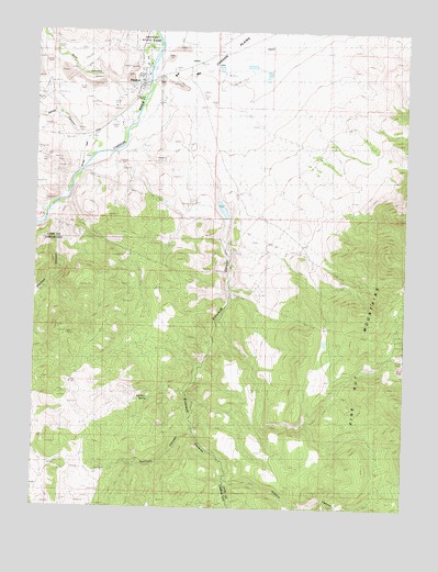
Dayton, NV USGS Topographic Map
Click on map above to begin viewing in our Map Viewer.

This topographic map contains these locations and features:
Feature Name Type Latitude Longitude GNIS ID View Map
Atlanta Mill (historical)LocaleN39.2449°W119.6196°847595View Map
Aurora Mill (historical)LocaleN39.2313°W119.5902°852322View Map
Barrys Mill (historical)LocaleN39.2449°W119.6216°852319View Map
Birdsall and Carpenter MillLocaleN39.2371°W119.5930°852339View Map
Bull Run SpringSpringN39.1538°W119.5873°839175View Map
Carson River Quartz Mill (historical)LocaleN39.2260°W119.5921°852331View Map
Central Lyon County Fire Protection District Dayton Valley Volunteer Fire Department Station 39BuildingN39.2453°W119.5652°2581243View Map
Daney CanyonValleyN39.2224°W119.6121°839921View Map
DaytonPopulated PlaceN39.2371°W119.5930°856226View Map
Dayton Elementary SchoolSchoolN39.2382°W119.5798°855283View Map
Dayton High SchoolSchoolN39.2388°W119.5727°855281View Map
Dayton Intermediate SchoolSchoolN39.2394°W119.5764°855282View Map
Dayton Placer MineMineN39.2382°W119.5891°855357View Map
Dayton Post OfficePost OfficeN39.2406°W119.5898°864742View Map
Dayton State ParkParkN39.2485°W119.5888°850759View Map
Dayton Station (historical)LocaleN39.2369°W119.5896°857450View Map
Dayton Town DitchCanalN39.2202°W119.6121°839931View Map
Dayton Valley AirparkAirportN39.2363°W119.5555°855481View Map
Dixon MineMineN39.1705°W119.6149°850760View Map
Eldorado CanyonValleyN39.2357°W119.5810°848543View Map
Eldorado Canyon DamDamN39.2066°W119.5627°863513View Map
Eldorado Canyon QuarryMineN39.2088°W119.5746°855359View Map
Eldorado Canyon ReservoirReservoirN39.2066°W119.5627°863514View Map
Eldorado Mining DistrictCivilN39.1924°W119.6080°855358View Map
Fiddlers GreenPopulated PlaceN39.1546°W119.6127°856786View Map
Franklin Mill (historical)LocaleN39.2146°W119.6093°852327View Map
Gold CanyonValleyN39.2341°W119.5955°857462View Map
Gold CreekStreamN39.2371°W119.5885°856682View Map
Goldy (historical)LocaleN39.2244°W119.6032°847631View Map
Hastings and Woodworth Mill (historical)LocaleN39.2257°W119.5924°852330View Map
Hulley-Logan MineMineN39.1624°W119.5018°847179View Map
Illinois CanyonValleyN39.1321°W119.5618°841224View Map
Illinois Mill (historical)LocaleN39.2430°W119.5868°852321View Map
Island Mill (historical)LocaleN39.2160°W119.6077°852328View Map
Jackson and Hunts MillLocaleN39.2371°W119.5930°852338View Map
Keller and Company MillLocaleN39.2371°W119.5930°852314View Map
Kustel and Winters MillLocaleN39.2371°W119.5930°857569View Map
Letter DLocaleN39.1999°W119.5718°858060View Map
Lyon County Sheriff StationBuildingN39.2357°W119.5919°2740043View Map
Lyon MillLocaleN39.2371°W119.5930°852312View Map
Mineral Rapids Mill (historical)LocaleN39.2460°W119.5846°856568View Map
Mineral Rapids Post Office (historical)Post OfficeN39.2369°W119.5874°864835View Map
Mosheimer MillLocaleN39.2371°W119.5930°852317View Map
New Dayton MillLocaleN39.2371°W119.5930°852326View Map
New Jerusalem (historical)LocaleN39.2291°W119.5352°857316View Map
New Ophir Mill (historical)LocaleN39.2244°W119.5957°852329View Map
Old Dayton MillLocaleN39.2371°W119.5930°852341View Map
Old Ophir Mill (historical)LocaleN39.2235°W119.5963°852320View Map
Pradere RanchLocaleN39.2285°W119.5943°847635View Map
Randall DitchCanalN39.2419°W119.5730°843080View Map
Reservoir MillLocaleN39.2371°W119.5930°852316View Map
Rock Point Mill (historical)LocaleN39.2494°W119.5857°857568View Map
Santa Maria RanchLocaleN39.2216°W119.6027°847634View Map
Solomon and Jacobs MillLocaleN39.2371°W119.5930°852313View Map
Solomon Davis MillLocaleN39.2371°W119.5930°852315View Map
Sprouls Mill (historical)LocaleN39.2244°W119.5949°852333View Map
Sullivan CanyonValleyN39.1455°W119.5741°844065View Map
Sutro MillLocaleN39.2371°W119.5930°852340View Map
Sweetapples MillLocaleN39.2371°W119.5930°852337View Map
Toll (historical)LocaleN39.1794°W119.5604°847625View Map
Weston and Company Mills (historical)LocaleN39.2460°W119.6227°852318View Map
Woodworth Mill (historical)LocaleN39.2252°W119.5943°852332View Map

Note: Coordinates in the location and feature list above are referenced to NAD83 datum.


Copyright (C) 2008-2024 Ryan Niemi / Sunset Dynamics ... All Rights Reserved