TopoQuest Logo
Do you find TopoQuest useful?
Help keep TopoQuest running and adding new maps/features by donating!
Bitcoin:  19c7KJd3qBynnjoSw5npx9KScwjBe4ifkT
Litecoin:  LXs6TkuXGGXo1vDsWCkWVdjQX94eUKd6ui
Home View Maps Find Maps Find Places Resources & Links


Deerfield, Wisconsin Topographic Map

USGS Map Title: Deerfield, WI
USGS Map MRC: 43089A1
DRG (GeoTIFF) Download: o43089a1.tif


Neighboring USGS Topographic Map Quads:


  Sun Prairie, WI  
43089B2
 

  Marshall, WI  
43089B1
 

  Waterloo, WI  
43088B8
 

  Cottage Grove, WI  
43089A2
 

  Deerfield, WI  
43089A1
 

  Lake Mills, WI  
43088A8
 

  Stoughton, WI  
42089H2
 

  Rockdale, WI  
42089H1
 

  Busseyville, WI  
42088H8


Map MRC Location:

N44°
W90°
N44°
W89°
H8 H7 H6 H5 H4 H3 H2 H1
G8 G7 G6 G5 G4 G3 G2 G1
F8 F7 F6 F5 F4 F3 F2 F1
E8 E7 E6 E5 E4 E3 E2 E1
D8 D7 D6 D5 D4 D3 D2 D1
C8 C7 C6 C5 C4 C3 C2 C1
B8 B7 B6 B5 B4 B3 B2 B1
A8 A7 A6 A5 A4 A3 A2 A1
N43°
W90°
N43°
W89°

Deerfield, WI USGS 1:24K Topographic Map Preview:
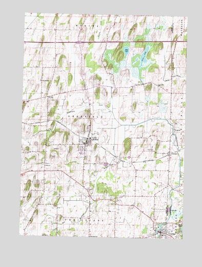
Deerfield, WI USGS Topographic Map
Click on map above to begin viewing in our Map Viewer.

This topographic map contains these locations and features:
Feature Name Type Latitude Longitude GNIS ID View Map
CambridgePopulated PlaceN43.0036°W89.0165°1562561View Map
Cambridge Area Emergency Medical ServicesBuildingN43.0043°W89.0227°2698252View Map
Cambridge Elementary SchoolSchoolN43.0020°W89.0296°1842352View Map
Cambridge High SchoolSchoolN43.0053°W89.0102°1840351View Map
Cambridge Police DepartmentBuildingN43.0030°W89.0174°2759821View Map
Cambridge Volunteer Fire DepartmentBuildingN43.0044°W89.0227°2698042View Map
Christiana FarmsLocaleN43.0008°W89.0811°2704146View Map
Coolwater FarmsLocaleN43.0256°W89.0392°2629214View Map
DeerfieldPopulated PlaceN43.0519°W89.0757°1563863View Map
Deerfield Elementary SchoolSchoolN43.0489°W89.0841°1842381View Map
Deerfield High SchoolSchoolN43.0471°W89.0801°1842382View Map
Deerfield Lutheran CemeteryCemeteryN43.0509°W89.0968°2781257View Map
Deerfield Middle SchoolSchoolN43.0470°W89.0800°2716439View Map
Deerfield Police DepartmentBuildingN43.0527°W89.0763°2759429View Map
Deerfield Volunteer Fire DepartmentBuildingN43.0579°W89.0692°2697806View Map
Deerfield Wastewater Treatment PlantLocaleN43.0561°W89.0700°2709443View Map
Gerike CemeteryCemeteryN43.0674°W89.0115°2781330View Map
Goose LakeLakeN43.1019°W89.0327°1565650View Map
Goose Lake Drumlins State Natural AreaParkN43.1014°W89.0487°1989926View Map
Goose Lake State Wildlife AreaParkN43.1006°W89.0459°1842438View Map
Hauge CemeteryCemeteryN43.0260°W89.0744°1566138View Map
Immanuel ChurchChurchN43.0864°W89.0218°1566867View Map
KroghvillePopulated PlaceN43.0617°W89.0082°1577685View Map
Lake Ripley CemeteryCemeteryN43.0041°W89.0015°2781326View Map
Liberty Lutheran CemeteryCemeteryN43.0409°W89.1077°2781284View Map
Liberty SchoolSchoolN43.0392°W89.1065°1568021View Map
LondonPopulated PlaceN43.0478°W89.0129°1568505View Map
Lutheran Moravian CemeteryCemeteryN43.0663°W89.0068°2781325View Map
Mikkelson FarmLocaleN43.0358°W89.1219°2629213View Map
Mud CreekStreamN43.0631°W89.0484°1569889View Map
Mud LakeLakeN43.1051°W89.0466°1569908View Map
Nikolay Middle SchoolSchoolN43.0017°W89.0159°2716613View Map
Oak ParkLocaleN43.0783°W89.1057°1570669View Map
Oak Park SchoolSchoolN43.0872°W89.1101°1570671View Map
Old DeerfieldPopulated PlaceN43.0831°W89.0757°1842597View Map
Pioneer Norwegian CemeteryCemeteryN43.0999°W89.1009°2781288View Map
Prairie Queen SchoolSchoolN43.0003°W89.0715°1571886View Map
Saint Anne's Catholic CemeteryCemeteryN43.0820°W89.0832°2781293View Map
Saint Paul ChurchChurchN43.0406°W89.1073°1573440View Map
Smithback FarmLocaleN43.0114°W89.1197°2629212View Map
Town of DeerfieldCivilN43.0671°W89.0704°1583061View Map
Vasby FarmsLocaleN43.0036°W89.0497°2704140View Map
Village of CambridgeCivilN43.0071°W89.0213°1582909View Map
Village of DeerfieldCivilN43.0492°W89.0761°1583060View Map
Willerup Methodist CemeteryCemeteryN43.0023°W89.0227°2781312View Map
WTFX-FM (Watertown)TowerN43.0589°W89.0618°1582636View Map

Note: Coordinates in the location and feature list above are referenced to NAD83 datum.


Copyright (C) 2008-2025 Ryan Niemi / Sunset Dynamics ... All Rights Reserved