TopoQuest Logo
Do you find TopoQuest useful?
Help keep TopoQuest running and adding new maps/features by donating!
Bitcoin:  19c7KJd3qBynnjoSw5npx9KScwjBe4ifkT
Litecoin:  LXs6TkuXGGXo1vDsWCkWVdjQX94eUKd6ui
Home View Maps Find Maps Find Places Resources & Links


Demers Ridge, Montana Topographic Map

USGS Map Title: Demers Ridge, MT
USGS Map MRC: 48114F2
DRG (GeoTIFF) Download: o48114f2.tif


Neighboring USGS Topographic Map Quads:


  Polebridge, MT  
48114G3
 

  Quartz Ridge, MT  
48114G2
 

  Vulture Peak, MT  
48114G1
 

  Cyclone Lake, MT  
48114F3
 

  Demers Ridge, MT  
48114F2
 

  Camas Ridge West, MT  
48114F1
 

  Skookoleel Creek, MT  
48114E3
 

  Huckleberry Mountain, MT  
48114E2
 

  McGee Meadow, MT  
48114E1


Map MRC Location:

N49°
W115°
N49°
W114°
H8 H7 H6 H5 H4 H3 H2 H1
G8 G7 G6 G5 G4 G3 G2 G1
F8 F7 F6 F5 F4 F3 F2 F1
E8 E7 E6 E5 E4 E3 E2 E1
D8 D7 D6 D5 D4 D3 D2 D1
C8 C7 C6 C5 C4 C3 C2 C1
B8 B7 B6 B5 B4 B3 B2 B1
A8 A7 A6 A5 A4 A3 A2 A1
N48°
W115°
N48°
W114°

Demers Ridge, MT USGS 1:24K Topographic Map Preview:
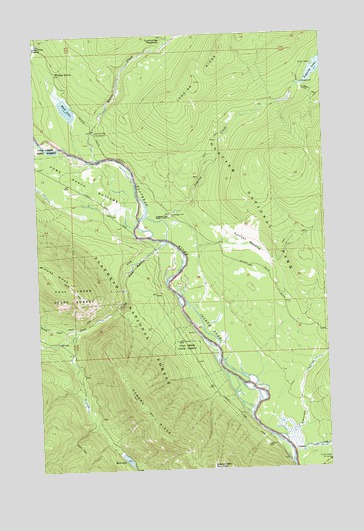
Demers Ridge, MT USGS Topographic Map
Click on map above to begin viewing in our Map Viewer.

This topographic map contains these locations and features:
Feature Name Type Latitude Longitude GNIS ID View Map
34N20W07DBB_01 WellWellN48.7225°W114.2246°1636290View Map
34N20W20DDA_01 WellWellN48.6980°W114.1935°1636234View Map
34N20W21BCB_01 WellWellN48.6986°W114.1915°1636235View Map
AdairLocaleN48.6972°W114.1926°798919View Map
Anaconda CreekStreamN48.6341°W114.1457°779018View Map
Camas CreekStreamN48.6300°W114.1418°780808View Map
Camas Creek EntranceLocaleN48.6266°W114.1265°780809View Map
Coal CreekStreamN48.6902°W114.1949°781441View Map
Cummings MeadowsFlatN48.7472°W114.1985°781988View Map
Cyclone CreekStreamN48.6650°W114.2387°782017View Map
Demers RidgeRidgeN48.6257°W114.1767°782287View Map
Glacier View MountainSummitN48.6258°W114.1768°783976View Map
Home Ranch BottomsBasinN48.7105°W114.2301°784968View Map
Logging CreekStreamN48.6914°W114.1943°786456View Map
Logging Creek CampgroundLocaleN48.6980°W114.1918°799068View Map
Logging Creek Ranger StationLocaleN48.6975°W114.1929°786458View Map
Mud LakeLakeN48.6281°W114.2141°787801View Map
Quartz CreekStreamN48.7147°W114.2237°789268View Map
Quartz Creek CampgroundLocaleN48.7222°W114.2246°789271View Map
Sullivan MeadowFlatN48.6891°W114.1612°791654View Map
The Coal BanksCliffN48.6841°W114.2096°792028View Map
Whiskey SpringSpringN48.7394°W114.2412°793180View Map
Winona LakeLakeN48.7291°W114.2368°787802View Map

Note: Coordinates in the location and feature list above are referenced to NAD83 datum.


Copyright (C) 2008-2025 Ryan Niemi / Sunset Dynamics ... All Rights Reserved