TopoQuest Logo
Do you find TopoQuest useful?
Help keep TopoQuest running and adding new maps/features by donating!
Bitcoin:  19c7KJd3qBynnjoSw5npx9KScwjBe4ifkT
Litecoin:  LXs6TkuXGGXo1vDsWCkWVdjQX94eUKd6ui
Home View Maps Find Maps Find Places Resources & Links


Demory, Tennessee Topographic Map

USGS Map Title: Demory, TN
USGS Map MRC: 36084C1
DRG (GeoTIFF) Download: o36084c1.tif


Neighboring USGS Topographic Map Quads:


  Ivydell, TN  
36084D2
 

  La Follette, TN  
36084D1
 

  Well Spring, TN  
36083D8
 

  Jacksboro, TN  
36084C2
 

  Demory, TN  
36084C1
 

  White Hollow, TN  
36083C8
 

  Lake City, TN  
36084B2
 

  Norris, TN  
36084B1
 

  Big Ridge Park, TN  
36083B8


Map MRC Location:

N37°
W85°
N37°
W84°
H8 H7 H6 H5 H4 H3 H2 H1
G8 G7 G6 G5 G4 G3 G2 G1
F8 F7 F6 F5 F4 F3 F2 F1
E8 E7 E6 E5 E4 E3 E2 E1
D8 D7 D6 D5 D4 D3 D2 D1
C8 C7 C6 C5 C4 C3 C2 C1
B8 B7 B6 B5 B4 B3 B2 B1
A8 A7 A6 A5 A4 A3 A2 A1
N36°
W85°
N36°
W84°

Demory, TN USGS 1:24K Topographic Map Preview:
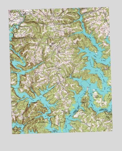
Demory, TN USGS Topographic Map
Click on map above to begin viewing in our Map Viewer.

This topographic map contains these locations and features:
Feature Name Type Latitude Longitude GNIS ID View Map
Agee (historical)Populated PlaceN36.3001°W84.0333°1307411View Map
Alder SpringsPopulated PlaceN36.3692°W84.0063°1314574View Map
Alder Springs Baptist ChurchChurchN36.3626°W84.0058°1318818View Map
Alder Springs School (historical)SchoolN36.3626°W84.0052°1318819View Map
Anderson County ParkParkN36.2815°W84.0358°1275712View Map
Anderson County Sportsmens ClubLocaleN36.2751°W84.0299°1307593View Map
Andrews CemeteryCemeteryN36.2520°W84.1230°1275744View Map
Baird CemeteryCemeteryN36.3634°W84.1219°1276126View Map
Baker Forge Memorial CemeteryCemeteryN36.3398°W84.0744°1304931View Map
Bald KnobSummitN36.3267°W84.0463°1276213View Map
Big CreekStreamN36.2526°W84.0735°1269336View Map
Big HollowValleyN36.2868°W84.0935°1277323View Map
Black CemeteryCemeteryN36.2648°W84.1127°1305261View Map
Blue SpringSpringN36.3651°W84.1058°1277793View Map
Blue Spring RidgeRidgeN36.3640°W84.0941°1277807View Map
Bolinger CemeteryCemeteryN36.2823°W84.0066°1277907View Map
Boshears Tree FarmLocaleN36.3414°W84.0422°2662626View Map
Boy (historical)Populated PlaceN36.3509°W84.0321°1311290View Map
Camp PellissippiLocaleN36.2679°W84.0033°1305635View Map
Campbell County Rural Fire Service Station 3BuildingN36.3240°W84.0615°2654907View Map
Cedar CreekStreamN36.3256°W84.0144°1280017View Map
Cedar Creek Baptist ChurchChurchN36.3704°W84.0244°1305759View Map
Cedar Creek BridgeBridgeN36.3676°W84.0358°1280018View Map
Central PeninsulaCapeN36.2798°W84.0074°1280176View Map
Chadwell CemeteryCemeteryN36.3548°W84.0683°1280185View Map
Chestnut Stump RidgeRidgeN36.3154°W84.0763°1280424View Map
Commissioner District 1CivilN36.3573°W84.0280°2464212View Map
Coolidge RidgeRidgeN36.3634°W84.0821°1281154View Map
Coolidge School (historical)SchoolN36.3601°W84.0696°1318829View Map
Cove Creek Wildlife Management AreaParkN36.2587°W84.0905°1306141View Map
Custer (historical)Populated PlaceN36.2584°W84.0133°1307627View Map
Daugherty CemeteryCemeteryN36.3045°W84.1216°1282076View Map
Deerfield Resort AirportAirportN36.3462°W84.0123°2675550View Map
DemoryPopulated PlaceN36.3365°W84.0660°1282331View Map
Demory Baptist ChurchChurchN36.3309°W84.0655°1306327View Map
Demory School (historical)SchoolN36.3365°W84.0644°1318839View Map
East Murrayville Cabin AreaLocaleN36.2692°W84.0541°1283388View Map
Elbow HollowValleyN36.3515°W84.0214°1283595View Map
FordtownPopulated PlaceN36.3656°W84.1185°1284575View Map
Fork BendBendN36.3031°W84.0177°1284616View Map
Four CornersLocaleN36.2723°W84.1241°1284717View Map
Gatham BendBendN36.3187°W84.0194°1285242View Map
Gaylor CemeteryCemeteryN36.2662°W84.1102°1318853View Map
GrantsboroPopulated PlaceN36.3148°W84.0680°1315145View Map
Grantsboro Baptist ChurchChurchN36.3145°W84.0663°1318855View Map
Grantsboro CemeteryCemeteryN36.3140°W84.0660°1318856View Map
Grantsboro School (historical)SchoolN36.3134°W84.0671°1318857View Map
Hatmaker (historical)Populated PlaceN36.2873°W84.0885°1311301View Map
Hatmaker CemeteryCemeteryN36.2698°W84.1130°1287145View Map
Heatherly Point Cabin AreaLocaleN36.3229°W84.0291°1287296View Map
Hicks CemeteryCemeteryN36.3453°W84.0874°1287654View Map
High KnobSummitN36.3506°W84.0888°1287698View Map
Housley CemeteryCemeteryN36.3656°W84.0638°1288500View Map
Jones CemeteryCemeteryN36.2692°W84.0357°1289751View Map
Kitts CemeteryCemeteryN36.3706°W84.0969°1290339View Map
La Follette Division (historical)CensusN36.3554°W84.1216°1648623View Map
Lick HollowValleyN36.3114°W84.1161°1291237View Map
Little Dividing RidgeRidgeN36.3654°W84.0177°1291473View Map
McFarland HollowValleyN36.3735°W84.0365°1293288View Map
Mill HollowValleyN36.3264°W84.1095°1293879View Map
Mount Moriah CemeteryCemeteryN36.2892°W84.0321°1294673View Map
Mount Pleasant CemeteryCemeteryN36.2617°W84.0155°1326304View Map
Mount Pleasant United Methodist ChurchChurchN36.2617°W84.0158°1306785View Map
Murrayville Baptist ChurchChurchN36.2715°W84.0599°1295150View Map
Murrayville CemeteryCemeteryN36.2720°W84.0594°1318888View Map
Negro RidgeRidgeN36.3554°W84.0524°1295353View Map
Oak Ridge Yacht ClubLocaleN36.2640°W84.0483°1307729View Map
Orick CemeteryCemeteryN36.3645°W84.0691°1318897View Map
Pellissippi Boat DockLocaleN36.2717°W84.0341°1297124View Map
Pellissippi PointCapeN36.2798°W84.0338°1297125View Map
Pellissippi Point Cabin AreaLocaleN36.2801°W84.0305°1297126View Map
Phillips BranchStreamN36.2926°W84.0058°1297334View Map
Pinecrest RidgeRidgeN36.2659°W84.1085°1297593View Map
Pleasant Ridge Church (historical)ChurchN36.3709°W84.0974°1318905View Map
Pleasant Ridge SchoolSchoolN36.3715°W84.1058°1297919View Map
Pond CemeteryCemeteryN36.3165°W84.0688°1298090View Map
Primroy (historical)Populated PlaceN36.3681°W84.0346°1311315View Map
Pyles CemeteryCemeteryN36.2609°W84.0027°1298726View Map
Racetrack HollowValleyN36.2934°W84.0782°1298800View Map
Rainbow Marina and ResortLocaleN36.3065°W84.0508°1318909View Map
Rich HollowValleyN36.3008°W84.0384°1299319View Map
Robbins CemeteryCemeteryN36.3734°W84.0099°1318913View Map
Sequoyah LandingLocaleN36.2579°W84.0535°1307745View Map
Sequoyah Landing Cabin AreaLocaleN36.2590°W84.0538°1647742View Map
Sequoyah MarinaLocaleN36.2595°W84.0535°1307746View Map
Shanghai BranchStreamN36.3329°W84.0366°1301214View Map
Shanghai DockLocaleN36.3356°W84.0394°1301216View Map
Shanghai ResortLocaleN36.3356°W84.0385°1318916View Map
Sharp CemeteryCemeteryN36.2842°W84.0480°1301261View Map
Shepard CemeteryCemeteryN36.3103°W84.0913°1270034View Map
Shoffner BranchStreamN36.3629°W84.1069°1270149View Map
Star Dust DockLocaleN36.2684°W84.0188°1307751View Map
Stillhouse HollowValleyN36.3702°W84.0385°1271424View Map
Stokes CemeteryCemeteryN36.3612°W84.0710°1271465View Map
Stooksbury CemeteryCemeteryN36.3206°W84.0205°1318923View Map
Sugar HollowValleyN36.3507°W84.0327°1271689View Map
Sugar Hollow ChurchChurchN36.3384°W84.0741°1271697View Map
Sugar Hollow ChurchChurchN36.3604°W84.0691°1303900View Map
Sutton CemeteryCemeteryN36.3684°W84.0516°1318925View Map
Sutton HollowValleyN36.3634°W84.0368°1271909View Map
Sutton RidgeRidgeN36.3667°W84.0458°1271911View Map
Sweeten SpringSpringN36.3462°W84.1073°1271976View Map
Sweeten Spring HollowValleyN36.3481°W84.1206°1271977View Map
Tanbark KnobSummitN36.3687°W84.0644°1272076View Map
Turkey RidgeRidgeN36.3390°W84.1077°1273031View Map
Upper Cumberland Council Boy Scout CampLocaleN36.2870°W84.0499°1318930View Map
Walters CemeteryCemeteryN36.3720°W84.1063°1273750View Map
Water Branch HollowValleyN36.3632°W84.1068°1273877View Map
Weaver CemeteryCemeteryN36.3348°W84.0769°1318938View Map
Whitakers Boat DockLocaleN36.3520°W84.0341°1318941View Map
Whitman (historical)Populated PlaceN36.3123°W84.1069°1311319View Map
Whitman HollowValleyN36.3120°W84.1076°1274484View Map
Whitman Hollow Boat DockLocaleN36.3179°W84.0927°1318943View Map
Whitman Hollow ChurchChurchN36.3384°W84.0899°1274485View Map
Willoughby HollowValleyN36.3673°W84.0342°1274752View Map
Wilson CemeteryCemeteryN36.3540°W84.0049°1304626View Map
Wolf HollowValleyN36.2828°W84.1171°1274967View Map
Woodward CemeteryCemeteryN36.3231°W84.0910°1275104View Map

Note: Coordinates in the location and feature list above are referenced to NAD83 datum.


Copyright (C) 2008-2025 Ryan Niemi / Sunset Dynamics ... All Rights Reserved