TopoQuest Logo
Do you find TopoQuest useful?
Help keep TopoQuest running and adding new maps/features by donating!
Bitcoin:  19c7KJd3qBynnjoSw5npx9KScwjBe4ifkT
Litecoin:  LXs6TkuXGGXo1vDsWCkWVdjQX94eUKd6ui
Home View Maps Find Maps Find Places Resources & Links


Norris, Tennessee Topographic Map

USGS Map Title: Norris, TN
USGS Map MRC: 36084B1
DRG (GeoTIFF) Download: o36084b1.tif


Neighboring USGS Topographic Map Quads:


  Jacksboro, TN  
36084C2
 

  Demory, TN  
36084C1
 

  White Hollow, TN  
36083C8
 

  Lake City, TN  
36084B2
 

  Norris, TN  
36084B1
 

  Big Ridge Park, TN  
36083B8
 

  Clinton, TN  
36084A2
 

  Powell, TN  
36084A1
 

  Fountain City, TN  
36083A8


Map MRC Location:

N37°
W85°
N37°
W84°
H8 H7 H6 H5 H4 H3 H2 H1
G8 G7 G6 G5 G4 G3 G2 G1
F8 F7 F6 F5 F4 F3 F2 F1
E8 E7 E6 E5 E4 E3 E2 E1
D8 D7 D6 D5 D4 D3 D2 D1
C8 C7 C6 C5 C4 C3 C2 C1
B8 B7 B6 B5 B4 B3 B2 B1
A8 A7 A6 A5 A4 A3 A2 A1
N36°
W85°
N36°
W84°

Norris, TN USGS 1:24K Topographic Map Preview:
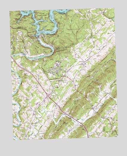
Norris, TN USGS Topographic Map
Click on map above to begin viewing in our Map Viewer.

This topographic map contains these locations and features:
Feature Name Type Latitude Longitude GNIS ID View Map
Anderson County Occupational Development SchoolSchoolN36.1617°W84.0860°1307592View Map
AndersonvillePopulated PlaceN36.1987°W84.0371°1307594View Map
Andersonville CemeteryCemeteryN36.1976°W84.0357°1326278View Map
Andersonville Census Designated PlaceCensusN36.1970°W84.0331°2586041View Map
Andersonville Elementary SchoolSchoolN36.1970°W84.0366°1307595View Map
Andersonville Post OfficePost OfficeN36.2031°W84.0290°1649326View Map
Andersonville Volunteer Fire Department Station 1BuildingN36.1979°W84.0367°2654503View Map
Andy BranchStreamN36.1415°W84.0491°1275751View Map
BelmontPopulated PlaceN36.2456°W84.0308°1314663View Map
Belmont School (historical)SchoolN36.2456°W84.0327°1307601View Map
BethelPopulated PlaceN36.1712°W84.0766°1277098View Map
Bethel Baptist ChurchChurchN36.1695°W84.0752°1317622View Map
Bethel CemeteryCemeteryN36.1690°W84.0749°1326281View Map
Big ValleyValleyN36.1850°W84.0585°1277437View Map
Bluebird Lookout TowerTowerN36.1398°W84.0635°1647761View Map
Bluebird RidgeRidgeN36.1734°W84.0332°1305315View Map
Brooks GapGapN36.1448°W84.0549°1278482View Map
Brushy CreekStreamN36.1290°W84.1024°1305476View Map
Buffalo CreekStreamN36.1540°W84.0866°1278910View Map
Buffalo ValleyValleyN36.1687°W84.0178°1307611View Map
Burris CemeteryCemeteryN36.2334°W84.1210°1279115View Map
Byrams ForkStreamN36.1604°W84.0155°1279242View Map
Carden GapGapN36.1631°W84.0041°1279657View Map
City of NorrisCivilN36.2106°W84.0629°2404388View Map
Civilian Conservation Corps Camp Number (historical)LocaleN36.2217°W84.0796°1307617View Map
Civilian Conservation Corps Camp Number 4493 (historical)LocaleN36.1959°W84.0841°1307619View Map
Civilian Conservation Corps Camp Number 4495 (historical)LocaleN36.1945°W84.0841°1307618View Map
Clear CemeteryCemeteryN36.2215°W84.0285°1280649View Map
Clear CreekStreamN36.2123°W84.0738°1280655View Map
Clear Creek SpringSpringN36.2164°W84.0493°1280670View Map
Clear SpringSpringN36.2223°W84.0280°1280680View Map
Coal CreekStreamN36.2065°W84.1224°1306000View Map
Commissioner District 3CivilN36.1957°W84.0392°2464118View Map
Cove CreekStreamN36.2298°W84.0910°1281407View Map
Cox CemeteryCemeteryN36.1612°W84.0655°1281489View Map
Dark HollowValleyN36.2007°W84.0044°1282058View Map
Davis CemeteryCemeteryN36.1651°W84.0891°1282156View Map
Deer TrailTrailN36.2154°W84.0727°1307632View Map
Disney CemeteryCemeteryN36.2084°W84.1249°1282497View Map
District 13 (historical)CivilN36.1501°W84.1235°1314179View Map
District 2 (historical)CivilN36.2251°W84.0249°1314170View Map
District 3 (historical)CivilN36.1501°W84.0999°1314171View Map
Fairview Baptist ChurchChurchN36.1445°W84.0166°1306435View Map
Fairview CemeteryCemeteryN36.1456°W84.0160°1326288View Map
Fairview Elementary SchoolSchoolN36.1531°W84.0277°1648325View Map
Foust CemeteryCemeteryN36.1487°W84.0582°1284733View Map
Foust CemeteryCemeteryN36.1642°W84.1044°1284734View Map
Foust CemeteryCemeteryN36.1645°W84.0455°1284735View Map
Foust CemeteryCemeteryN36.1912°W84.1249°1284737View Map
Foust HollowValleyN36.1483°W84.0586°1284738View Map
Fox Mill (historical)LocaleN36.2406°W84.0060°1307649View Map
Gibbs CemeteryCemeteryN36.2012°W84.0263°1285332View Map
Glen Alpine Junior High SchoolSchoolN36.1609°W84.0858°1285497View Map
GooseneckPopulated PlaceN36.2217°W84.0271°1315134View Map
Gooseneck HollowValleyN36.2145°W84.0254°1285689View Map
Harmon CemeteryCemeteryN36.2367°W84.1121°1286886View Map
Hart CemeteryCemeteryN36.1415°W84.1091°1287041View Map
Hawkins CemeteryCemeteryN36.2284°W84.1108°1287180View Map
Heavenly HollowValleyN36.2006°W84.0053°1287302View Map
Hibbs IslandIslandN36.2095°W84.0744°1287530View Map
Hickory ValleyValleyN36.1712°W84.0074°1269641View Map
High PointSummitN36.2242°W84.0688°1287710View Map
HillvalePopulated PlaceN36.1754°W84.0958°1287851View Map
Hillvale Baptist ChurchChurchN36.1773°W84.0958°1326293View Map
Hillvale CemeteryCemeteryN36.1778°W84.0960°1326294View Map
Hinds Creek (historical)Populated PlaceN36.1381°W84.0899°1307662View Map
Hinds Creek Baptist ChurchChurchN36.1334°W84.0944°1287872View Map
Indian GapGapN36.1806°W84.0249°1288985View Map
Indian Gap ChurchChurchN36.1842°W84.0313°1288987View Map
Interchange 122CrossingN36.1667°W84.0819°1307665View Map
Irwin CemeteryCemeteryN36.1748°W84.0521°1289061View Map
Island FordCrossingN36.2048°W84.0924°1307668View Map
Island Ford Baptist ChurchChurchN36.2201°W84.1171°1289087View Map
Island Ford CemeteryCemeteryN36.2198°W84.1171°1326297View Map
Island Home Baptist ChurchChurchN36.2009°W84.0855°1289089View Map
IvoryPopulated PlaceN36.1662°W84.0082°1646918View Map
John CreekStreamN36.1512°W84.0777°1289479View Map
Johnsons ShoalsBarN36.1834°W84.1146°1642315View Map
Lenoir MuseumBuildingN36.2120°W84.0730°1307688View Map
Liberty ChurchChurchN36.1615°W84.0477°1291137View Map
Lone MountainRidgeN36.1984°W84.0155°1269756View Map
Lone Mountain ChurchChurchN36.1954°W84.0152°1291846View Map
Lone Mountain School (historical)SchoolN36.1954°W84.0149°1307692View Map
Longmire CemeteryCemeteryN36.2162°W84.0760°1292021View Map
Lovely Mill (historical)LocaleN36.2148°W84.1244°1307696View Map
Loys Mill (historical)LocaleN36.2001°W84.0030°1307697View Map
Macedonia Baptist ChurchChurchN36.2417°W84.0777°1652429View Map
Macedonia CemeteryCemeteryN36.2412°W84.0785°1318880View Map
Macedonia Church (historical)ChurchN36.2212°W84.0280°1307699View Map
MaplesPopulated PlaceN36.1548°W84.1235°1315462View Map
Massengill BridgeBridgeN36.2073°W84.1085°1292898View Map
Massengill HollowValleyN36.2042°W84.1041°1292901View Map
Mill CreekPopulated PlaceN36.2451°W84.0133°1315508View Map
Miller CemeteryCemeteryN36.2012°W84.0841°1293927View Map
Miller HollowValleyN36.2055°W84.0920°1293950View Map
Miller IslandIslandN36.2037°W84.0946°1293953View Map
Miller SpringSpringN36.1432°W84.0074°1293967View Map
Moore CemeteryCemeteryN36.1376°W84.0474°1294272View Map
Moore CemeteryCemeteryN36.2012°W84.1213°1294275View Map
Moore GapGapN36.1342°W84.0396°1294288View Map
Moores Gap Methodist ChurchChurchN36.1356°W84.0410°1294289View Map
Mount Pleasant Baptist ChurchChurchN36.1679°W84.0085°1294774View Map
Mount Pleasant CemeteryCemeteryN36.1684°W84.0091°1326303View Map
Museum of AppalachiaBuildingN36.1817°W84.0685°1295167View Map
Nelson SpringSpringN36.2455°W84.0141°1295390View Map
New Home CemeteryCemeteryN36.2378°W84.0027°1326307View Map
New Home Missionary Baptist ChurchChurchN36.2376°W84.0030°1306819View Map
NorrisPopulated PlaceN36.1956°W84.0680°1295831View Map
Norris Aquatic CenterLocaleN36.2262°W84.0969°1295832View Map
Norris DamDamN36.2242°W84.0913°1306838View Map
Norris Dam State ParkParkN36.2384°W84.1105°1295837View Map
Norris Division (historical)CensusN36.1815°W84.0544°1648593View Map
Norris Elementary SchoolSchoolN36.1987°W84.0655°1307715View Map
Norris Evaporation Station (historical)BuildingN36.2023°W84.0880°1307716View Map
Norris Fire DepartmentBuildingN36.1975°W84.0706°2654431View Map
Norris Forestry Research AreaForestN36.2070°W84.0777°1295839View Map
Norris Memorial GardensCemeteryN36.1817°W84.0719°1295840View Map
Norris Middle SchoolSchoolN36.1954°W84.0702°1307717View Map
Norris Municipal ParkParkN36.2187°W84.0655°1295841View Map
Norris ParkPopulated PlaceN36.2251°W84.0780°1295842View Map
Norris Police DepartmentBuildingN36.1974°W84.0707°2765890View Map
Norris Post OfficePost OfficeN36.1967°W84.0707°1649352View Map
Norris Town ForestForestN36.2334°W84.0541°1307718View Map
Oakgrove CemeteryCemeteryN36.2253°W84.0032°1296173View Map
Observation PointSummitN36.2090°W84.0702°1296227View Map
Old Red Hill CemeteryCemeteryN36.2256°W84.0530°1296353View Map
Overton CemeteryCemeteryN36.1478°W84.0777°1296548View Map
Panther (historical)Populated PlaceN36.1265°W84.0346°1307730View Map
Pumpkin HollowValleyN36.1490°W84.0628°1298679View Map
Pyle CemeteryCemeteryN36.2398°W84.0007°1298725View Map
Red Hill Baptist ChurchChurchN36.2209°W84.0335°1299064View Map
Red Hill CemeteryCemeteryN36.2212°W84.0346°1326313View Map
Reservoir HillSummitN36.2101°W84.0624°1299228View Map
Riner Farm AirportAirportN36.1831°W84.0994°2675551View Map
River Bluff Small Wild AreaParkN36.2159°W84.0888°1307736View Map
River Bluff TrailTrailN36.2137°W84.0838°1307737View Map
River RidgeCliffN36.1759°W84.1158°1299503View Map
Riverview School (historical)SchoolN36.2098°W84.1088°1307738View Map
Roberts CemeteryCemeteryN36.1304°W84.1144°1299631View Map
Ross CemeteryCemeteryN36.1820°W84.1182°1300120View Map
Scenic WoodsLocaleN36.1301°W84.0088°1300876View Map
Scruggs CemeteryCemeteryN36.1787°W84.0735°1300980View Map
Sequoyah DockLocaleN36.2481°W84.0541°1301074View Map
Sinking Springs CemeteryCemeteryN36.1406°W84.1038°1326315View Map
Sinking Springs United Methodist ChurchChurchN36.1406°W84.1027°1303644View Map
Strong HollowValleyN36.2152°W84.1250°1271607View Map
Taylor Chapel CemeteryCemeteryN36.1301°W84.0941°1272224View Map
Taylor Chapel CemeteryCemeteryN36.1301°W84.0944°1272225View Map
Underwood CemeteryCemeteryN36.1590°W84.0210°1273171View Map
Wallace CemeteryCemeteryN36.1367°W84.1160°1273673View Map
Wallace CemeteryCemeteryN36.1470°W84.0794°1273674View Map
Wallace CemeteryCemeteryN36.1890°W84.0610°1273676View Map
West OverlookLocaleN36.2231°W84.0952°1307764View Map
Whitaker HollowValleyN36.2047°W84.1041°1274325View Map
Williams SpringSpringN36.2126°W84.0708°1274715View Map

Note: Coordinates in the location and feature list above are referenced to NAD83 datum.


Copyright (C) 2008-2025 Ryan Niemi / Sunset Dynamics ... All Rights Reserved