TopoQuest Logo
Do you find TopoQuest useful?
Help keep TopoQuest running and adding new maps/features by donating!
Bitcoin:  19c7KJd3qBynnjoSw5npx9KScwjBe4ifkT
Litecoin:  LXs6TkuXGGXo1vDsWCkWVdjQX94eUKd6ui
Home View Maps Find Maps Find Places Resources & Links


Dennis, Kansas Topographic Map

USGS Map Title: Dennis, KS
USGS Map MRC: 37095C4
DRG (GeoTIFF) Download: o37095c4.tif


Neighboring USGS Topographic Map Quads:


  Morehead, KS  
37095D5
 

  Thayer, KS  
37095D4
 

  Galesburg, KS  
37095D3
 

  Cherryvale, KS  
37095C5
 

  Dennis, KS  
37095C4
 

  Parsons West, KS  
37095C3
 

  Liberty, KS  
37095B5
 

  Mound Valley, KS  
37095B4
 

  Altamont, KS  
37095B3


Map MRC Location:

N38°
W96°
N38°
W95°
H8 H7 H6 H5 H4 H3 H2 H1
G8 G7 G6 G5 G4 G3 G2 G1
F8 F7 F6 F5 F4 F3 F2 F1
E8 E7 E6 E5 E4 E3 E2 E1
D8 D7 D6 D5 D4 D3 D2 D1
C8 C7 C6 C5 C4 C3 C2 C1
B8 B7 B6 B5 B4 B3 B2 B1
A8 A7 A6 A5 A4 A3 A2 A1
N37°
W96°
N37°
W95°

Dennis, KS USGS 1:24K Topographic Map Preview:
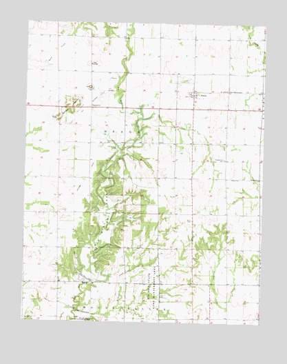
Dennis, KS USGS Topographic Map
Click on map above to begin viewing in our Map Viewer.

This topographic map contains these locations and features:
Feature Name Type Latitude Longitude GNIS ID View Map
Bender MoundsSummitN37.3403°W95.4769°469797View Map
Big Hill DamDamN37.2687°W95.4691°469801View Map
Big Hill LakeReservoirN37.2921°W95.4586°469802View Map
Big Hill SidingLocaleN37.2537°W95.4697°483687View Map
Big Hill Wildlife AreaParkN37.2667°W95.4336°469433View Map
Carpenter School (historical)SchoolN37.3173°W95.4669°483696View Map
DennisPopulated PlaceN37.3470°W95.4128°484487View Map
Dennis United Methodist ChurchChurchN37.3458°W95.4141°2688911View Map
FernPopulated PlaceN37.3470°W95.3764°484486View Map
GrovePopulated PlaceN37.3251°W95.4308°484485View Map
Harmony CemeteryCemeteryN37.3254°W95.4580°469798View Map
Maple Grove School (historical)SchoolN37.3395°W95.4997°483731View Map
Maple Valley School (historical)SchoolN37.3401°W95.3766°483733View Map
Mortimer (historical)LocaleN37.3251°W95.4880°481953View Map
Mount Triumph School (historical)SchoolN37.2659°W95.4428°483735View Map
Mount Zion Church (historical)ChurchN37.2881°W95.4825°483736View Map
Mount Zion School (historical)SchoolN37.2765°W95.4825°483737View Map
Osage Township Fire DepartmentBuildingN37.3462°W95.4122°2111694View Map
Pleasant Hill CemeteryCemeteryN37.3187°W95.3957°469799View Map
Pleasant Hill ChurchChurchN37.3106°W95.3769°469800View Map
Pleasant Hill School (historical)SchoolN37.2937°W95.3939°483747View Map
Salem Church (historical)ChurchN37.2953°W95.4114°483761View Map
Sylvandale School (historical)SchoolN37.3687°W95.4214°483771View Map
Timber Hill School (historical)SchoolN37.2951°W95.4294°483772View Map
Township of OsageCivilN37.3253°W95.4468°469815View Map
Twin MoundsSummitN37.3581°W95.4655°469796View Map
Twin Mounds School (historical)SchoolN37.3615°W95.4664°483774View Map

Note: Coordinates in the location and feature list above are referenced to NAD83 datum.


Copyright (C) 2008-2024 Ryan Niemi / Sunset Dynamics ... All Rights Reserved