TopoQuest Logo
Do you find TopoQuest useful?
Help keep TopoQuest running and adding new maps/features by donating!
Bitcoin:  19c7KJd3qBynnjoSw5npx9KScwjBe4ifkT
Litecoin:  LXs6TkuXGGXo1vDsWCkWVdjQX94eUKd6ui
Home View Maps Find Maps Find Places Resources & Links


Denver, North Carolina Topographic Map

USGS Map Title: Denver, NC
USGS Map MRC: 35081E1
DRG (GeoTIFF) Download: o35081e1.tif


Neighboring USGS Topographic Map Quads:


  Newton, NC  
35081F2
 

  Catawba, NC  
35081F1
 

  Troutman, NC  
35080F8
 

  Maiden, NC  
35081E2
 

  Denver, NC  
35081E1
 

  Lake Norman North, NC  
35080E8
 

  Lincolnton East, NC  
35081D2
 

  Lowesville, NC  
35081D1
 

  Lake Norman South, NC  
35080D8


Map MRC Location:

N36°
W82°
N36°
W81°
H8 H7 H6 H5 H4 H3 H2 H1
G8 G7 G6 G5 G4 G3 G2 G1
F8 F7 F6 F5 F4 F3 F2 F1
E8 E7 E6 E5 E4 E3 E2 E1
D8 D7 D6 D5 D4 D3 D2 D1
C8 C7 C6 C5 C4 C3 C2 C1
B8 B7 B6 B5 B4 B3 B2 B1
A8 A7 A6 A5 A4 A3 A2 A1
N35°
W82°
N35°
W81°

Denver, NC USGS 1:24K Topographic Map Preview:
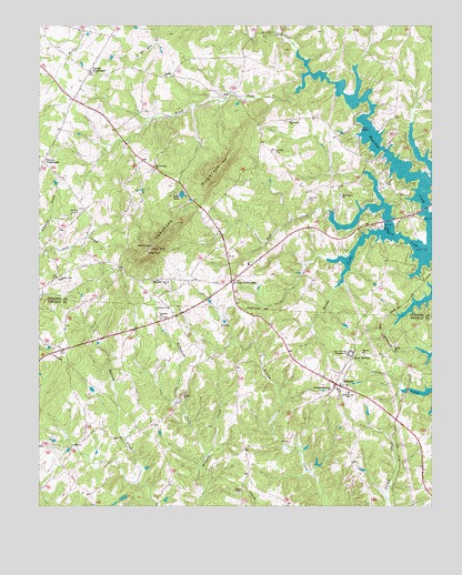
Denver, NC USGS Topographic Map
Click on map above to begin viewing in our Map Viewer.

This topographic map contains these locations and features:
Feature Name Type Latitude Longitude GNIS ID View Map
Anderson MountainRangeN35.5846°W81.0709°980182View Map
Bethel ChurchChurchN35.5412°W81.0117°981141View Map
Bevard ChurchChurchN35.5396°W81.0223°981285View Map
Camp DogwoodLocaleN35.5990°W81.0231°982528View Map
Center View ChurchChurchN35.5587°W81.1181°982944View Map
DenverPopulated PlaceN35.5312°W81.0298°1019954View Map
Denver Census Designated PlaceCensusN35.5344°W81.0339°2584315View Map
Denver Post OfficePost OfficeN35.5249°W81.0177°2774038View Map
Denver Volunteer Fire DepartmentBuildingN35.5346°W81.0355°2638623View Map
Denver Volunteer Fire Department Kidville StationBuildingN35.5030°W81.0501°2639421View Map
Drums CrossroadsPopulated PlaceN35.6132°W81.1087°1020033View Map
Friendly ChurchChurchN35.5487°W81.0862°985417View Map
Jones LakeReservoirN35.5815°W81.0798°987757View Map
Jones Lake DamDamN35.5818°W81.0798°999112View Map
Killian CrossroadsPopulated PlaceN35.5587°W81.0640°987962View Map
Laneys AirportAirportN35.5763°W81.1128°997941View Map
Lebanon ChurchChurchN35.5512°W81.0842°988265View Map
Lincoln County Emergency Medical ServicesBuildingN35.5345°W81.0354°2720433View Map
Little Mountain Aircraft DamDamN35.5918°W81.0765°999131View Map
Little Mountain Aircraft LakeReservoirN35.5918°W81.0765°999130View Map
Little Mountain AirportAirportN35.5918°W81.0818°997943View Map
Mount Anderson ChurchChurchN35.5874°W81.0884°990309View Map
Mount Pleasant ChurchChurchN35.5804°W81.0287°990537View Map
Mountain Beulah ChurchChurchN35.6001°W81.0456°990683View Map
Mountain View ChurchChurchN35.5582°W81.0842°990720View Map
Mundy CreekStreamN35.5712°W81.0162°990796View Map
Olivers CrossroadsPopulated PlaceN35.5890°W81.1234°1021744View Map
Ore Bank Pumpkin Center Volunteer Fire DepartmentBuildingN35.5399°W81.1167°2638353View Map
Pisgah ChurchChurchN35.6121°W81.0854°992415View Map
Pooles ChapelChurchN35.5032°W81.0612°992665View Map
Quinlen LakeReservoirN35.5301°W81.1048°999068View Map
Quinlen Lake DamDamN35.5301°W81.1048°999069View Map
Reed CreekStreamN35.5660°W81.0034°993154View Map
Rock SpringsSpringN35.5379°W81.0251°993526View Map
Rock Springs CampgroundLocaleN35.5393°W81.0259°993527View Map
Rock Springs Elementary SchoolSchoolN35.5293°W81.0265°1024854View Map
Sherrills Ford Terrell Fire and Rescue Base 2BuildingN35.5741°W81.0358°2639206View Map
South Fork Mountain CreekStreamN35.6132°W81.0392°995157View Map
Thompson Memorial ChurchChurchN35.5299°W81.0320°996056View Map
Township of Mountain CreekCivilN35.5978°W81.0117°1026529View Map
Victory ChurchChurchN35.5287°W81.0787°996622View Map
Wilkinson CreekStreamN35.5129°W81.0715°997341View Map

Note: Coordinates in the location and feature list above are referenced to NAD83 datum.


Copyright (C) 2008-2025 Ryan Niemi / Sunset Dynamics ... All Rights Reserved