TopoQuest Logo
Do you find TopoQuest useful?
Help keep TopoQuest running and adding new maps/features by donating!
Bitcoin:  19c7KJd3qBynnjoSw5npx9KScwjBe4ifkT
Litecoin:  LXs6TkuXGGXo1vDsWCkWVdjQX94eUKd6ui
Home View Maps Find Maps Find Places Resources & Links


Lowesville, North Carolina Topographic Map

USGS Map Title: Lowesville, NC
USGS Map MRC: 35081D1
DRG (GeoTIFF) Download: o35081d1.tif


Neighboring USGS Topographic Map Quads:


  Maiden, NC  
35081E2
 

  Denver, NC  
35081E1
 

  Lake Norman North, NC  
35080E8
 

  Lincolnton East, NC  
35081D2
 

  Lowesville, NC  
35081D1
 

  Lake Norman South, NC  
35080D8
 

  Gastonia North, NC  
35081C2
 

  Mount Holly, NC  
35081C1
 

  Mountain Island Lake, NC  
35080C8


Map MRC Location:

N36°
W82°
N36°
W81°
H8 H7 H6 H5 H4 H3 H2 H1
G8 G7 G6 G5 G4 G3 G2 G1
F8 F7 F6 F5 F4 F3 F2 F1
E8 E7 E6 E5 E4 E3 E2 E1
D8 D7 D6 D5 D4 D3 D2 D1
C8 C7 C6 C5 C4 C3 C2 C1
B8 B7 B6 B5 B4 B3 B2 B1
A8 A7 A6 A5 A4 A3 A2 A1
N35°
W82°
N35°
W81°

Lowesville, NC USGS 1:24K Topographic Map Preview:
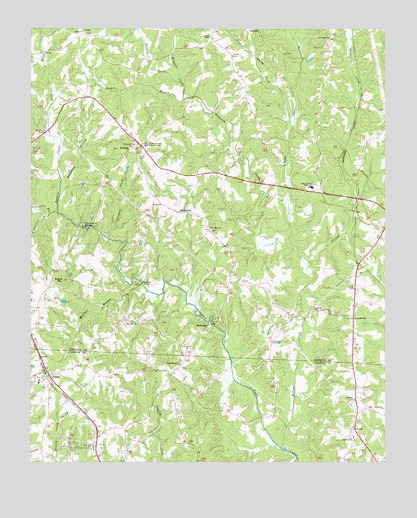
Lowesville, NC USGS Topographic Map
Click on map above to begin viewing in our Map Viewer.

This topographic map contains these locations and features:
Feature Name Type Latitude Longitude GNIS ID View Map
AlexisPopulated PlaceN35.3999°W81.1179°1018790View Map
Alexis Post OfficePost OfficeN35.3996°W81.1175°2773894View Map
Alexis Volunteer Fire Department Station 20 Base 1BuildingN35.3987°W81.1172°2639418View Map
Alexis Volunteer Fire Department Station 20 Base 2BuildingN35.4628°W81.0868°2639419View Map
Amity ChurchChurchN35.4996°W81.1065°980166View Map
Anderson CreekStreamN35.4379°W81.0326°980177View Map
Armstrong BranchStreamN35.4471°W81.1179°980284View Map
Ballard CreekStreamN35.4846°W81.0723°980496View Map
Bradshaw BranchStreamN35.4512°W81.1145°981812View Map
Brevards Forge (historical)LocaleN35.4262°W81.0856°1001766View Map
CansellersPopulated PlaceN35.4699°W81.1179°1001767View Map
Castanea ChurchChurchN35.3932°W81.0109°982736View Map
Castanea Church CemeteryCemeteryN35.3924°W81.0097°2779099View Map
Catawba SpringsSpringN35.4924°W81.0276°1023367View Map
Catfish LakeReservoirN35.4551°W81.0881°998985View Map
Catfish Lake DamDamN35.4551°W81.0881°998984View Map
Cottage Home (historical)Populated PlaceN35.4160°W81.0312°1001770View Map
Craig Memorial ChurchChurchN35.4035°W81.0720°983702View Map
Crooked CreekStreamN35.4393°W81.0962°983764View Map
Dellinger BranchStreamN35.4471°W81.1151°984126View Map
East Lincoln High SchoolSchoolN35.4546°W81.0256°984514View Map
East Lincoln Junior High SchoolSchoolN35.4740°W81.0934°1001777View Map
Episcopal Church LakeReservoirN35.4585°W81.0915°998992View Map
Episcopal Church Lake DamDamN35.4585°W81.0915°998993View Map
Faith ChurchChurchN35.4496°W81.0790°984949View Map
Forney CemeteryCemeteryN35.4629°W81.0870°985311View Map
Forney CreekStreamN35.4312°W81.0273°985312View Map
Fortneys ForgeLocaleN35.4107°W81.0398°1001774View Map
Gold Hill ChurchChurchN35.4190°W81.0245°985771View Map
Gold Hill Church CemeteryCemeteryN35.4180°W81.0256°2779101View Map
Hills ChapelChurchN35.4251°W81.0109°986820View Map
Hills Chapel CemeteryCemeteryN35.4243°W81.0101°2779100View Map
Hooper BranchStreamN35.4796°W81.0709°987030View Map
Keever CemeteryCemeteryN35.4923°W81.0537°987885View Map
Killian CreekStreamN35.3790°W81.0362°987961View Map
Leepers CreekStreamN35.3790°W81.0359°988307View Map
LowesvillePopulated PlaceN35.4171°W81.0112°989108View Map
LuciaPopulated PlaceN35.3849°W81.0106°989116View Map
MachpelahPopulated PlaceN35.4474°W81.0723°989209View Map
Machpelah CemeteryCemeteryN35.4658°W81.0893°2779104View Map
Machpelah ChurchChurchN35.4654°W81.0901°989210View Map
MariposaPopulated PlaceN35.4146°W81.0623°1021348View Map
McClure BranchStreamN35.4243°W81.0837°989538View Map
McClure BridgeBridgeN35.4268°W81.0856°989539View Map
McDowell BridgeBridgeN35.4432°W81.1054°989563View Map
Mineral Spring (historical)Populated PlaceN35.4171°W81.0117°1001787View Map
Mount Zion CemeteryCemeteryN35.4144°W81.0911°2779093View Map
Mount Zion ChurchChurchN35.4151°W81.0912°990645View Map
New Hope ChurchChurchN35.4426°W81.0615°991007View Map
New Hope Church CemeteryCemeteryN35.4421°W81.0612°2779102View Map
Pooles ChapelChurchN35.4976°W81.0615°992664View Map
Reed CreekStreamN35.4690°W81.1176°993157View Map
Reese MountainSummitN35.4279°W81.1131°993217View Map
Rehobeth Furnace (historical)BuildingN35.4718°W81.1229°1001792View Map
Reinhardt BridgeBridgeN35.4704°W81.1198°993237View Map
Rock Hill ChurchChurchN35.4185°W81.0192°993512View Map
Saint James ChurchChurchN35.4976°W81.0195°993907View Map
Smith PondReservoirN35.4551°W81.1065°998986View Map
Smith Pond DamDamN35.4551°W81.1065°998987View Map
Snow Hill CemeteryCemeteryN35.3807°W81.0107°2779098View Map
Snow Hill ChurchChurchN35.3815°W81.0106°995068View Map
Snyder CreekStreamN35.4704°W81.0331°995081View Map
Township of Catawba SpringsCivilN35.4761°W81.0175°1026886View Map
Triangle (historical)Populated PlaceN35.4826°W81.0098°1001794View Map
Tuckers Grove CampgroundLocaleN35.4671°W81.0840°996300View Map
Tuckers Grove ChurchChurchN35.4660°W81.0865°996301View Map
Tuckers Grove Methodist CemeteryCemeteryN35.4655°W81.0859°2779103View Map
Wingate CreekStreamN35.4796°W81.0706°997490View Map

Note: Coordinates in the location and feature list above are referenced to NAD83 datum.


Copyright (C) 2008-2024 Ryan Niemi / Sunset Dynamics ... All Rights Reserved