TopoQuest Logo
Do you find TopoQuest useful?
Help keep TopoQuest running and adding new maps/features by donating!
Bitcoin:  19c7KJd3qBynnjoSw5npx9KScwjBe4ifkT
Litecoin:  LXs6TkuXGGXo1vDsWCkWVdjQX94eUKd6ui
Home View Maps Find Maps Find Places Resources & Links


Derby, Texas Topographic Map

USGS Map Title: Derby, TX
USGS Map MRC: 28099G2
DRG (GeoTIFF) Download: o28099g2.tif


Neighboring USGS Topographic Map Quads:


  Holcomb Reservoir, TX  
28099H3
 

  Halff Ranch, TX  
28099H2
 

  Pearsall North, TX  
28099H1
 

  Divot, TX  
28099G3
 

  Derby, TX  
28099G2
 

  Pearsall South, TX  
28099G1
 

  Woodward NE, TX  
28099F3
 

  Dilley, TX  
28099F2
 

  Dilley NE, TX  
28099F1


Map MRC Location:

N29°
W100°
N29°
W99°
H8 H7 H6 H5 H4 H3 H2 H1
G8 G7 G6 G5 G4 G3 G2 G1
F8 F7 F6 F5 F4 F3 F2 F1
E8 E7 E6 E5 E4 E3 E2 E1
D8 D7 D6 D5 D4 D3 D2 D1
C8 C7 C6 C5 C4 C3 C2 C1
B8 B7 B6 B5 B4 B3 B2 B1
A8 A7 A6 A5 A4 A3 A2 A1
N28°
W100°
N28°
W99°

Derby, TX USGS 1:24K Topographic Map Preview:
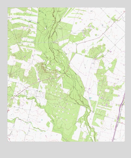
Derby, TX USGS Topographic Map
Click on map above to begin viewing in our Map Viewer.

This topographic map contains these locations and features:
Feature Name Type Latitude Longitude GNIS ID View Map
Abispa WindmillLocaleN28.8425°W99.2211°1350853View Map
Brushy WindmillLocaleN28.8325°W99.1886°1353096View Map
Buck CreekStreamN28.7653°W99.1636°1353125View Map
Chapote TankReservoirN28.8656°W99.2357°1354315View Map
Chivo WindmillLocaleN28.8652°W99.2481°1354454View Map
Costilla TankReservoirN28.8628°W99.2249°1355040View Map
Cude TankReservoirN28.8716°W99.2148°1355459View Map
DerbyPopulated PlaceN28.7714°W99.1286°1379655View Map
Derby ColoniaPopulated PlaceN28.7722°W99.1323°2009981View Map
Herbert WindmillLocaleN28.8425°W99.1995°1359060View Map
Honeymoon WindmillLocaleN28.8608°W99.2189°1359512View Map
Jesse WindmillLocaleN28.8550°W99.2098°1360244View Map
Live Oak CreekStreamN28.8130°W99.1886°1361539View Map
Oil Field WindmillLocaleN28.8536°W99.1689°1364352View Map
Panther HollowValleyN28.7716°W99.2415°1364788View Map
Pearsall Oil FieldOilfieldN28.8383°W99.1848°1375385View Map
Penn WindmillLocaleN28.8494°W99.1564°1365040View Map
Round Mountain WindmillLocaleN28.8716°W99.1959°1366961View Map
Sing WindmillLocaleN28.8641°W99.1623°1368318View Map
Todos Santos CreekStreamN28.7683°W99.2028°1376473View Map
Upper Brushy WindmillLocaleN28.8553°W99.1923°1370492View Map
Zartuche WindmillLocaleN28.8719°W99.1623°1372082View Map

Note: Coordinates in the location and feature list above are referenced to NAD83 datum.


Copyright (C) 2008-2025 Ryan Niemi / Sunset Dynamics ... All Rights Reserved