TopoQuest Logo
Do you find TopoQuest useful?
Help keep TopoQuest running and adding new maps/features by donating!
Bitcoin:  19c7KJd3qBynnjoSw5npx9KScwjBe4ifkT
Litecoin:  LXs6TkuXGGXo1vDsWCkWVdjQX94eUKd6ui
Home View Maps Find Maps Find Places Resources & Links


Halff Ranch, Texas Topographic Map

USGS Map Title: Halff Ranch, TX
USGS Map MRC: 28099H2
DRG (GeoTIFF) Download: o28099h2.tif


Neighboring USGS Topographic Map Quads:


  Frio Town, TX  
29099A3
 

  Wilson Ranch, TX  
29099A2
 

  Moore, TX  
29099A1
 

  Holcomb Reservoir, TX  
28099H3
 

  Halff Ranch, TX  
28099H2
 

  Pearsall North, TX  
28099H1
 

  Divot, TX  
28099G3
 

  Derby, TX  
28099G2
 

  Pearsall South, TX  
28099G1


Map MRC Location:

N29°
W100°
N29°
W99°
H8 H7 H6 H5 H4 H3 H2 H1
G8 G7 G6 G5 G4 G3 G2 G1
F8 F7 F6 F5 F4 F3 F2 F1
E8 E7 E6 E5 E4 E3 E2 E1
D8 D7 D6 D5 D4 D3 D2 D1
C8 C7 C6 C5 C4 C3 C2 C1
B8 B7 B6 B5 B4 B3 B2 B1
A8 A7 A6 A5 A4 A3 A2 A1
N28°
W100°
N28°
W99°

Halff Ranch, TX USGS 1:24K Topographic Map Preview:
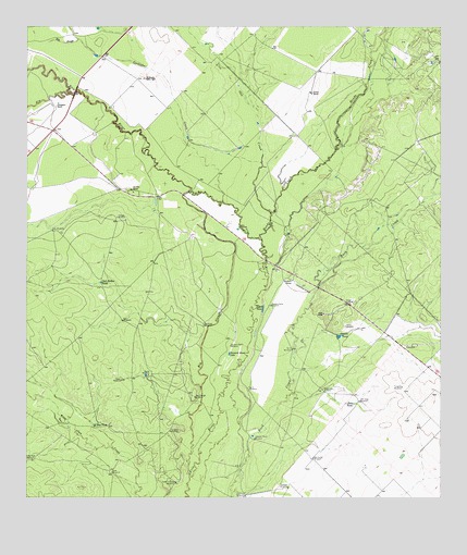
Halff Ranch, TX USGS Topographic Map
Click on map above to begin viewing in our Map Viewer.

This topographic map contains these locations and features:
Feature Name Type Latitude Longitude GNIS ID View Map
Barrel WindmillLocaleN28.9077°W99.2131°1351542View Map
Big SloughStreamN28.8816°W99.2011°1352137View Map
Big SloughStreamN28.9972°W99.2348°1352138View Map
Bob Smith WindmillLocaleN28.8858°W99.1636°1352545View Map
Buzzard Roost LakeLakeN28.9134°W99.1892°1353458View Map
Buzzard Roost WindmillLocaleN28.9155°W99.1884°1353460View Map
Cocklebur CreekStreamN28.9508°W99.1761°1354718View Map
Cocklebur WindmillLocaleN28.8927°W99.2067°1354720View Map
Cude Crossing WindmillPopulated PlaceN28.8791°W99.2053°1379619View Map
Cude WindmillLocaleN28.8819°W99.2242°1355460View Map
Dove TankReservoirN28.9002°W99.1517°1356222View Map
El Rancho Quien SabeLocaleN28.9866°W99.2139°1356874View Map
Elm CreekStreamN28.9825°W99.2367°1373631View Map
Forest WindmillLocaleN28.9064°W99.2217°1357569View Map
H and B RanchLocaleN28.9330°W99.1695°1358553View Map
Halff RanchLocaleN28.9239°W99.1606°1358651View Map
Hog TankReservoirN28.8944°W99.2299°1359375View Map
Hondo CreekStreamN28.9436°W99.1789°1374127View Map
Hunters Camp WindmillLocaleN28.9264°W99.1761°1359843View Map
Javalin TankReservoirN28.9180°W99.1563°1360166View Map
Javalin WindmillLocaleN28.9208°W99.1539°1360167View Map
Jewel LakeLakeN28.9252°W99.1786°1360247View Map
Jewel Lake WindmillLocaleN28.9036°W99.1614°1360248View Map
John Gray WindmillLocaleN28.9008°W99.1495°1360300View Map
Johnson Ranch WindmillLocaleN28.8905°W99.1811°1360345View Map
Little Field WindmillLocaleN28.8755°W99.1842°1361352View Map
Little Steel WindmillLocaleN28.8852°W99.2486°1361481View Map
Live Oak CreekStreamN28.9508°W99.1761°1361540View Map
Number Five WindmillLocaleN28.9039°W99.1828°1363935View Map
Number Three WindmillLocaleN28.9147°W99.1698°1363932View Map
Pranglin WindmillLocaleN28.9044°W99.1367°1365748View Map
Rio Frio RanchLocaleN28.9572°W99.2186°1366496View Map
Robledo WindmillLocaleN28.8777°W99.1711°1366623View Map
Rockhole WindmillLocaleN28.9211°W99.1964°1366728View Map
Salt Hollow TankReservoirN28.9323°W99.2280°1367435View Map
Salty WindmillLocaleN28.9461°W99.2425°1367454View Map
Stoker RanchLocaleN28.9827°W99.1639°1369229View Map
Thompson RanchLocaleN28.9794°W99.2420°1369856View Map
Tortuga WindmillLocaleN28.9497°W99.2228°1370044View Map
Twin WindmillsLocaleN28.9222°W99.2211°1370379View Map
West Slough WindmillLocaleN28.9019°W99.1992°1371226View Map

Note: Coordinates in the location and feature list above are referenced to NAD83 datum.


Copyright (C) 2008-2025 Ryan Niemi / Sunset Dynamics ... All Rights Reserved