TopoQuest Logo
Do you find TopoQuest useful?
Help keep TopoQuest running and adding new maps/features by donating!
Bitcoin:  19c7KJd3qBynnjoSw5npx9KScwjBe4ifkT
Litecoin:  LXs6TkuXGGXo1vDsWCkWVdjQX94eUKd6ui
Home View Maps Find Maps Find Places Resources & Links


Des Arc, Missouri Topographic Map

USGS Map Title: Des Arc, MO
USGS Map MRC: 37090C6
DRG (GeoTIFF) Download: o37090c6.tif


Neighboring USGS Topographic Map Quads:


  Lesterville, MO  
37090D7
 

  Glover, MO  
37090D6
 

  Des Arc NE, MO  
37090D5
 

  Lesterville SE, MO  
37090C7
 

  Des Arc, MO  
37090C6
 

  Brunot, MO  
37090C5
 

  Clearwater Dam, MO  
37090B7
 

  Piedmont, MO  
37090B6
 

  Patterson, MO  
37090B5


Map MRC Location:

N38°
W91°
N38°
W90°
H8 H7 H6 H5 H4 H3 H2 H1
G8 G7 G6 G5 G4 G3 G2 G1
F8 F7 F6 F5 F4 F3 F2 F1
E8 E7 E6 E5 E4 E3 E2 E1
D8 D7 D6 D5 D4 D3 D2 D1
C8 C7 C6 C5 C4 C3 C2 C1
B8 B7 B6 B5 B4 B3 B2 B1
A8 A7 A6 A5 A4 A3 A2 A1
N37°
W91°
N37°
W90°

Des Arc, MO USGS 1:24K Topographic Map Preview:
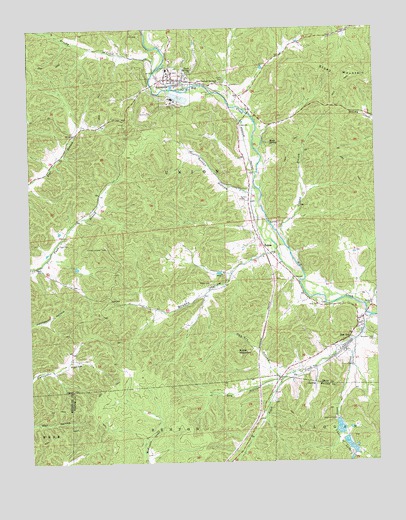
Des Arc, MO USGS Topographic Map
Click on map above to begin viewing in our Map Viewer.

This topographic map contains these locations and features:
Feature Name Type Latitude Longitude GNIS ID View Map
AnnapolisPopulated PlaceN37.3603°W90.6976°713303View Map
Annapolis Lead Mine (historical)MineN37.3639°W90.6760°736663View Map
Annapolis Post OfficePost OfficeN37.3607°W90.6948°2783164View Map
Black CreekStreamN37.2887°W90.6293°748878View Map
Brushy CreekStreamN37.3625°W90.7043°749064View Map
Brushy HollowValleyN37.3084°W90.6668°714911View Map
Cedar Spring HollowValleyN37.2951°W90.6254°715618View Map
Chain of LakesReservoirN37.2620°W90.6390°715697View Map
Chain of Lakes Dam Number 1DamN37.2620°W90.6390°764086View Map
Chain of Lakes Dam Number 2DamN37.2567°W90.6368°764088View Map
Chain of Lakes Dam Number 3DamN37.2534°W90.6351°764868View Map
City of AnnapolisCivilN37.3605°W90.6976°2393963View Map
Des Acre HollowValleyN37.2750°W90.6618°716846View Map
Des ArcPopulated PlaceN37.2826°W90.6373°716847View Map
Dinger Iron BankMineN37.3128°W90.6960°736668View Map
Dry HollowValleyN37.2734°W90.6610°717123View Map
Funk CemeteryCemeteryN37.3131°W90.7393°718295View Map
Funk SchoolSchoolN37.3139°W90.7385°748105View Map
Goose CreekStreamN37.2917°W90.6273°750082View Map
International Speciality Products Minerals Annapolis QuarryMineN37.3512°W90.7049°2681085View Map
Island BranchStreamN37.3117°W90.6568°720178View Map
Kinney BranchStreamN37.3525°W90.6754°736664View Map
LeadannaLocaleN37.3587°W90.6982°736667View Map
Lewis CemeteryCemeteryN37.3598°W90.6799°720936View Map
Lewis MountainSummitN37.2873°W90.7035°754180View Map
Mountain View CemeteryCemeteryN37.2845°W90.6262°722997View Map
New Peace and Harmony ChurchChurchN37.3595°W90.6810°723289View Map
Ruble CemeteryCemeteryN37.3017°W90.6848°725650View Map
Ruble MountainSummitN37.2820°W90.6757°725651View Map
Shy LakeReservoirN37.2558°W90.6364°764089View Map
Shy LakeReservoirN37.2536°W90.6341°764869View Map
Shy Lake 2ReservoirN37.2598°W90.6389°764087View Map
Singer Iron BankMineN37.3042°W90.6810°736666View Map
Sisk CemeteryCemeteryN37.2956°W90.6465°726490View Map
Slab PondLakeN37.2625°W90.7101°730455View Map
Slabtown ValleyValleyN37.2637°W90.7051°730454View Map
Southern Iron County Fire Protection District Annapolis StationBuildingN37.3614°W90.6993°2621784View Map
Southern Iron County Fire Protection District Des Arc StationBuildingN37.2833°W90.6368°2621777View Map
Stony MountainSummitN37.3609°W90.6337°727148View Map
Sutton CemeteryCemeteryN37.3256°W90.6737°727348View Map
Sutton HollowValleyN37.3267°W90.6707°727351View Map
Sutton School (historical)SchoolN37.3295°W90.6710°748106View Map
Tank SpringSpringN37.3631°W90.6940°727448View Map
Township of UnionCivilN37.3410°W90.6526°766798View Map
Village of Des ArcCivilN37.2838°W90.6352°2398715View Map
VulcanPopulated PlaceN37.3095°W90.6626°728225View Map
Vulcan Lookout TowerTowerN37.3120°W90.7223°755444View Map
Vulcan School (historical)SchoolN37.3059°W90.6773°736665View Map
Wallace CemeteryCemeteryN37.2956°W90.6268°728277View Map
Webb SpringSpringN37.3420°W90.6626°728464View Map

Note: Coordinates in the location and feature list above are referenced to NAD83 datum.


Copyright (C) 2008-2024 Ryan Niemi / Sunset Dynamics ... All Rights Reserved