TopoQuest Logo
Do you find TopoQuest useful?
Help keep TopoQuest running and adding new maps/features by donating!
Bitcoin:  19c7KJd3qBynnjoSw5npx9KScwjBe4ifkT
Litecoin:  LXs6TkuXGGXo1vDsWCkWVdjQX94eUKd6ui
Home View Maps Find Maps Find Places Resources & Links


Des Moines, New Mexico Topographic Map

USGS Map Title: Des Moines, NM
USGS Map MRC: 36103G7
DRG (GeoTIFF) Download: o36103g7.tif


Neighboring USGS Topographic Map Quads:


  Alps Mesa, NM  
36103H8
 

  Emery Peak, NM  
36103H7
 

  Cross L Ranch, NM  
36103H6
 

  Folsom, NM  
36103G8
 

  Des Moines, NM  
36103G7
 

  Cross L Ranch SW, NM  
36103G6
 

  Capulin, NM  
36103F8
 

  Little Grande, NM  
36103F7
 

  Wetherly Lake, NM  
36103F6


Map MRC Location:

N37°
W104°
N37°
W103°
H8 H7 H6 H5 H4 H3 H2 H1
G8 G7 G6 G5 G4 G3 G2 G1
F8 F7 F6 F5 F4 F3 F2 F1
E8 E7 E6 E5 E4 E3 E2 E1
D8 D7 D6 D5 D4 D3 D2 D1
C8 C7 C6 C5 C4 C3 C2 C1
B8 B7 B6 B5 B4 B3 B2 B1
A8 A7 A6 A5 A4 A3 A2 A1
N36°
W104°
N36°
W103°

Des Moines, NM USGS 1:24K Topographic Map Preview:
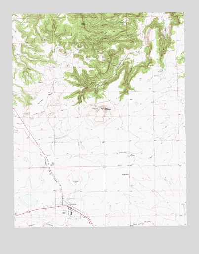
Des Moines, NM USGS Topographic Map
Click on map above to begin viewing in our Map Viewer.

This topographic map contains these locations and features:
Feature Name Type Latitude Longitude GNIS ID View Map
10246 Water WellWellN36.7606°W103.8539°934587View Map
10305 Water WellWellN36.8259°W103.7950°935393View Map
10306 Water WellWellN36.8267°W103.8441°934589View Map
Allen WindmillLocaleN36.7914°W103.7908°885702View Map
Brown CanyonValleyN36.8734°W103.7677°886760View Map
Burnt CanyonValleyN36.8628°W103.7836°886946View Map
Carr MountainSummitN36.8195°W103.8102°887216View Map
Colomex PitMineN36.8167°W103.8647°917858View Map
Colorado and Southern Ballast PitMineN36.8117°W103.8697°917859View Map
Crow WindmillLocaleN36.7739°W103.7913°888114View Map
Des MoinesPopulated PlaceN36.7611°W103.8341°899607View Map
Des Moines - Folsom Emergency Medical ServicesBuildingN36.7623°W103.8347°2657679View Map
Des Moines Catholic CemeteryCemeteryN36.7632°W103.8368°932414View Map
Des Moines CemeteryCemeteryN36.7716°W103.8310°932402View Map
Des Moines Elementary SchoolSchoolN36.7584°W103.8341°914689View Map
Des Moines Fire DepartmentBuildingN36.7619°W103.8351°2657941View Map
Des Moines High SchoolSchoolN36.7584°W103.8341°914690View Map
Des Moines Post OfficePost OfficeN36.7616°W103.8357°938170View Map
Des Moines Weather StationLocaleN36.7611°W103.8341°932570View Map
Dunchee HillSummitN36.7761°W103.8286°898761View Map
First Baptist MissionChurchN36.7611°W103.8341°921244View Map
Fowler CanyonValleyN36.8495°W103.7877°889199View Map
Hen WindmillLocaleN36.7806°W103.7925°889896View Map
Los LujanesLocaleN36.8100°W103.8725°927340View Map
Mitchel CanyonValleyN36.8675°W103.7808°892119View Map
Mitchel SpringsSpringN36.8684°W103.8212°892121View Map
Pachta WindmillLocaleN36.8517°W103.7861°893001View Map
Purvine HillsSummitN36.8167°W103.8544°893564View Map
Purvine MesaSummitN36.8161°W103.8564°898842View Map
Roberts WindmillLocaleN36.8406°W103.7669°910352View Map
Twin MountainSummitN36.8378°W103.8414°924794View Map
Village of Des MoinesCivilN36.7625°W103.8357°2413546View Map

Note: Coordinates in the location and feature list above are referenced to NAD83 datum.


Copyright (C) 2008-2024 Ryan Niemi / Sunset Dynamics ... All Rights Reserved