TopoQuest Logo
Do you find TopoQuest useful?
Help keep TopoQuest running and adding new maps/features by donating!
Bitcoin:  19c7KJd3qBynnjoSw5npx9KScwjBe4ifkT
Litecoin:  LXs6TkuXGGXo1vDsWCkWVdjQX94eUKd6ui
Home View Maps Find Maps Find Places Resources & Links


Devils Fence, Montana Topographic Map

USGS Map Title: Devils Fence, MT
USGS Map MRC: 46111B7
DRG (GeoTIFF) Download: o46111b7.tif


Neighboring USGS Topographic Map Quads:


  Elkhorn, MT  
46111C8
 

  Crow Creek Falls, MT  
46111C7
 

  Giant Hill, MT  
46111C6
 

  Tacoma Park, MT  
46111B8
 

  Devils Fence, MT  
46111B7
 

  Radersburg, MT  
46111B6
 

  Dunn Creek, MT  
46111A8
 

  Willow Springs, MT  
46111A7
 

  Radersburg SW, MT  
46111A6


Map MRC Location:

N47°
W112°
N47°
W111°
H8 H7 H6 H5 H4 H3 H2 H1
G8 G7 G6 G5 G4 G3 G2 G1
F8 F7 F6 F5 F4 F3 F2 F1
E8 E7 E6 E5 E4 E3 E2 E1
D8 D7 D6 D5 D4 D3 D2 D1
C8 C7 C6 C5 C4 C3 C2 C1
B8 B7 B6 B5 B4 B3 B2 B1
A8 A7 A6 A5 A4 A3 A2 A1
N46°
W112°
N46°
W111°

Devils Fence, MT USGS 1:24K Topographic Map Preview:
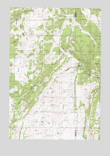
Devils Fence, MT USGS Topographic Map
Click on map above to begin viewing in our Map Viewer.

This topographic map contains these locations and features:
Feature Name Type Latitude Longitude GNIS ID View Map
Boyd SpringSpringN46.1413°W111.8328°780337View Map
Dahlman GulchValleyN46.2094°W111.7894°782038View Map
Devils FenceRidgeN46.1599°W111.8486°782331View Map
Doughty RanchLocaleN46.2338°W111.8405°782508View Map
Frenchman HillSummitN46.1952°W111.7583°806168View Map
Hope SpringSpringN46.2428°W111.8166°806170View Map
Kimpton Cow CampLocaleN46.1952°W111.7741°785737View Map
Lower SpringSpringN46.1842°W111.7563°806167View Map
North Fork Johnny GulchValleyN46.1947°W111.7691°788191View Map
Rogers SpringSpringN46.2263°W111.8542°789746View Map
Saddle GulchValleyN46.2333°W111.7864°806169View Map
Sagebrush ParkFlatN46.1947°W111.8625°806164View Map
Sand CreekStreamN46.2435°W111.8636°789999View Map
SE NE Section 18 MineMineN46.1869°W111.7691°802642View Map
SE NE Section 31 MineMineN46.1441°W111.7672°802641View Map
SE SE Section 31 MineMineN46.1380°W111.7683°802640View Map
Silver SpringSpringN46.2492°W111.7596°806171View Map
Spar MineMineN46.2324°W111.7925°803461View Map
Spar MineMineN46.2327°W111.7925°791132View Map
Spears GulchValleyN46.1952°W111.7747°806165View Map
Spears Gulch SpringSpringN46.1946°W111.7825°806166View Map
Star RanchLocaleN46.1294°W111.8041°791449View Map
Trail SpringSpringN46.1313°W111.8064°792326View Map
Turman CreekStreamN46.2474°W111.8622°792468View Map

Note: Coordinates in the location and feature list above are referenced to NAD83 datum.


Copyright (C) 2008-2025 Ryan Niemi / Sunset Dynamics ... All Rights Reserved