TopoQuest Logo
Do you find TopoQuest useful?
Help keep TopoQuest running and adding new maps/features by donating!
Bitcoin:  19c7KJd3qBynnjoSw5npx9KScwjBe4ifkT
Litecoin:  LXs6TkuXGGXo1vDsWCkWVdjQX94eUKd6ui
Home View Maps Find Maps Find Places Resources & Links


Antlers West, Oklahoma Topographic Map

USGS Map Title: Antlers West, OK
USGS Map MRC: 34095B6
DRG (GeoTIFF) Download: o34095b6.tif


Neighboring USGS Topographic Map Quads:


  Farris, OK  
34095C7
 

  Moyers, OK  
34095C6
 

  Kosoma, OK  
34095C5
 

  Darwin, OK  
34095B7
 

  Antlers West, OK  
34095B6
 

  Antlers East, OK  
34095B5
 

  Boswell, OK  
34095A7
 

  Soper, OK  
34095A6
 

  Hugo, OK  
34095A5


Map MRC Location:

N35°
W96°
N35°
W95°
H8 H7 H6 H5 H4 H3 H2 H1
G8 G7 G6 G5 G4 G3 G2 G1
F8 F7 F6 F5 F4 F3 F2 F1
E8 E7 E6 E5 E4 E3 E2 E1
D8 D7 D6 D5 D4 D3 D2 D1
C8 C7 C6 C5 C4 C3 C2 C1
B8 B7 B6 B5 B4 B3 B2 B1
A8 A7 A6 A5 A4 A3 A2 A1
N34°
W96°
N34°
W95°

Antlers West, OK USGS 1:24K Topographic Map Preview:
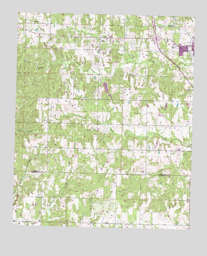
Antlers West, OK USGS Topographic Map
Click on map above to begin viewing in our Map Viewer.

This topographic map contains these locations and features:
Feature Name Type Latitude Longitude GNIS ID View Map
Antlers City CemeteryCemeteryN34.2264°W95.6275°2708532View Map
Antlers Fire Department Substation and Training FacilityBuildingN34.2290°W95.6379°2656927View Map
Antlers Municipal AirportAirportN34.1916°W95.6514°1102360View Map
Charlie CreekStreamN34.1743°W95.6258°1091215View Map
Coffee CreekStreamN34.2218°W95.6655°1091536View Map
Darwin Volunteer Fire DepartmentBuildingN34.2397°W95.7433°2657307View Map
Edwards CemeteryCemeteryN34.1923°W95.6614°1092494View Map
Hall Volunteer Fire DepartmentBuildingN34.1860°W95.6724°2657317View Map
Kellond ChurchChurchN34.2443°W95.6408°1094315View Map
Krebs LakeReservoirN34.1318°W95.7002°1751467View Map
Krebs Lake DamDamN34.1318°W95.7002°1751466View Map
NelsonPopulated PlaceN34.1273°W95.6852°1100669View Map
Nelson Volunteer Fire DepartmentBuildingN34.1279°W95.6943°2657064View Map
Oknoname 127001 DamDamN34.1951°W95.6436°1755807View Map
Oknoname 127001 ReservoirReservoirN34.1951°W95.6436°1755808View Map
Oknoname 127002 DamDamN34.1968°W95.6352°1755805View Map
Oknoname 127002 ReservoirReservoirN34.1960°W95.6358°1755806View Map
Pierce ChurchChurchN34.1270°W95.7427°1096625View Map
Sugarloaf ChurchChurchN34.2445°W95.7394°1098607View Map
Township of AntlersCivilN34.2404°W95.6433°1824700View Map

Note: Coordinates in the location and feature list above are referenced to NAD83 datum.


Copyright (C) 2008-2025 Ryan Niemi / Sunset Dynamics ... All Rights Reserved