TopoQuest Logo
Do you find TopoQuest useful?
Help keep TopoQuest running and adding new maps/features by donating!
Bitcoin:  19c7KJd3qBynnjoSw5npx9KScwjBe4ifkT
Litecoin:  LXs6TkuXGGXo1vDsWCkWVdjQX94eUKd6ui
Home View Maps Find Maps Find Places Resources & Links


Farris, Oklahoma Topographic Map

USGS Map Title: Farris, OK
USGS Map MRC: 34095C7
DRG (GeoTIFF) Download: o34095c7.tif


Neighboring USGS Topographic Map Quads:


  Lane NW, OK  
34095D8
 

  Lane NE, OK  
34095D7
 

  Jumbo, OK  
34095D6
 

  Lane, OK  
34095C8
 

  Farris, OK  
34095C7
 

  Moyers, OK  
34095C6
 

  Boswell NW, OK  
34095B8
 

  Darwin, OK  
34095B7
 

  Antlers West, OK  
34095B6


Map MRC Location:

N35°
W96°
N35°
W95°
H8 H7 H6 H5 H4 H3 H2 H1
G8 G7 G6 G5 G4 G3 G2 G1
F8 F7 F6 F5 F4 F3 F2 F1
E8 E7 E6 E5 E4 E3 E2 E1
D8 D7 D6 D5 D4 D3 D2 D1
C8 C7 C6 C5 C4 C3 C2 C1
B8 B7 B6 B5 B4 B3 B2 B1
A8 A7 A6 A5 A4 A3 A2 A1
N34°
W96°
N34°
W95°

Farris, OK USGS 1:24K Topographic Map Preview:
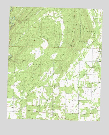
Farris, OK USGS Topographic Map
Click on map above to begin viewing in our Map Viewer.

This topographic map contains these locations and features:
Feature Name Type Latitude Longitude GNIS ID View Map
Blue CreekStreamN34.3584°W95.8580°1090279View Map
Cat HollowValleyN34.3161°W95.8735°1091035View Map
Center PointLocaleN34.2562°W95.8141°1091144View Map
Center Point ChurchChurchN34.2507°W95.8144°1091148View Map
Clear CreekStreamN34.3504°W95.7564°1091415View Map
Colby CreekStreamN34.2684°W95.7516°1091552View Map
Crooked CreekStreamN34.3159°W95.8741°1091835View Map
Davenport CreekStreamN34.3112°W95.7519°1091942View Map
East Sandy CreekStreamN34.2737°W95.8550°1092435View Map
FarrisPopulated PlaceN34.2626°W95.8666°1092768View Map
Farris Elementary SchoolSchoolN34.2588°W95.8746°1092769View Map
Grassy HollowValleyN34.3609°W95.8655°1093333View Map
Impson ValleyValleyN34.3111°W95.7518°1094059View Map
Little Davenport CreekStreamN34.3095°W95.7628°1094751View Map
Long MountainSummitN34.3709°W95.7894°1094965View Map
Mill CreekStreamN34.3595°W95.8714°1095398View Map
North Branch Elm CreekStreamN34.2923°W95.7525°1095920View Map
Oknoname 127004 DamDamN34.2918°W95.7753°1755801View Map
Oknoname 127004 ReservoirReservoirN34.2918°W95.7753°1755802View Map
Pine CreekStreamN34.3376°W95.7597°1096646View Map
Pine Springs SchoolSchoolN34.2876°W95.8133°1096672View Map
Prairie HollowValleyN34.3329°W95.8747°1096900View Map
Rough HollowValleyN34.3337°W95.7924°1097481View Map
Rough HollowValleyN34.3426°W95.8330°1097482View Map
Round Lake ChurchChurchN34.2648°W95.8333°1097489View Map
South Branch Elm CreekStreamN34.2923°W95.7525°1098211View Map
Sugarloaf CemeteryCemeteryN34.2651°W95.7616°1098606View Map
Sugarloaf HillSummitN34.2851°W95.7675°1098608View Map
Township of FarrisCivilN34.3057°W95.8697°1824968View Map
West Sandy CreekStreamN34.2820°W95.8533°1099603View Map
Yerby BranchStreamN34.3004°W95.7755°1100055View Map
Zoraya CemeteryCemeteryN34.3312°W95.7708°1100089View Map

Note: Coordinates in the location and feature list above are referenced to NAD83 datum.


Copyright (C) 2008-2025 Ryan Niemi / Sunset Dynamics ... All Rights Reserved